Lining Up Mystara XIII
Thanks for the feedback from yesterday’s posts. Today I’m going to concentrate on applying the different placements of Davania and the resulting latitudes to the 3D model.
Size Problems
Unfortunately, it turns out that this is not as easy as I would have liked. Why? Because of the polar openings.
The size of the Hollow World is reasonably fixed. Official sources give a circumference of 11,908 miles, and the full extent of official maps fits quite neatly into this space. The only question for me is how much land to fold into the polar openings; recently I have been thinking that the majority of land shown on the Hollow World poster map should not fold into the openings. Official maps seem to support this.
The problem is, if there is a large difference in size between the inner and outer worlds, the polar openings get smaller and smaller, and eventually disappear. This can be fixed by lowering the latitude of the beginning of the polar lip, but that of course means folding even more land into the openings.
The problem lies in the amount of space the hex mapped areas take up on the Outer World.
Let’s take a look at the placements I proposed yesterday, and see how they do.
Placement 1
Count the hexes between the two horizontal graticule lines here:
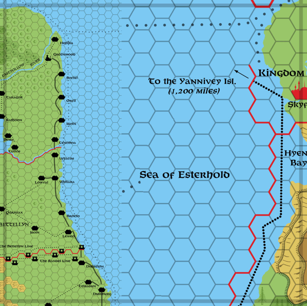
I count roughly 12.75 hexes from line to line; this represents 10º of latitude. At 72 miles per hex, we can do a simple calculation to find out how much land 1º of latitude on the Outer World takes up: 12.75 x 72 / 10. 12.75 x 72 = 918. 918 / 10 = 91.8, so that’s 91.8 miles per 1 degree of latitude.
In comparison, earth has roughly 69 miles per degree. So this Mystara is going to be significantly larger than earth. How large? Simply multiply by 360 to get the circumference of the spheroid: 33,048 miles, compared to earth’s 24,860 miles.
Some of you may at this point think, “Wait a minute, isn’t earth an ellipsoid, not a sphere?” Yes, it is, and the circumference I just quoted is the polar circumference (since we’re measuring latitudes). The equatorial circumference is about 24,902 miles. So yes, there’s a difference of around 42 miles — a pretty minor difference, and one that’s not hugely relevant to this discussion. I will likely define Mystara as an ellipsoid later in this project, when I create a coordinate system, complete with its own reference ellipsoid. But note that this minor equatorial increase in circumference is not really enough to help us solve the problems at hand, so let’s ignore it for now.
Getting back to Placement 1, what would this look like on our model, with the polar lip starting at 66º in both the Hollow and Outer worlds?
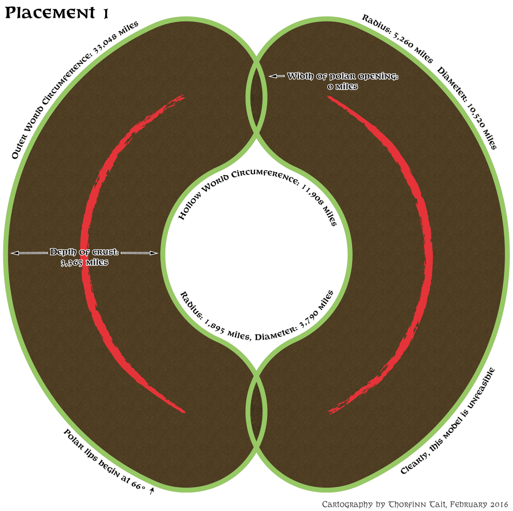
Oh dear. So there would be no polar openings at all.
In order to fix this, we need to do one or all of the following:
- Decrease the size of the Outer World.
- Increase the size of the Hollow World.
- Move back the lips of the polar openings in one or both worlds.
Placement 2
Happily, we have already done this with Placement 2: by rescaling the latitudes, I shrunk the dimensions of the Outer World. But is it enough? Let’s count the hexes and see.
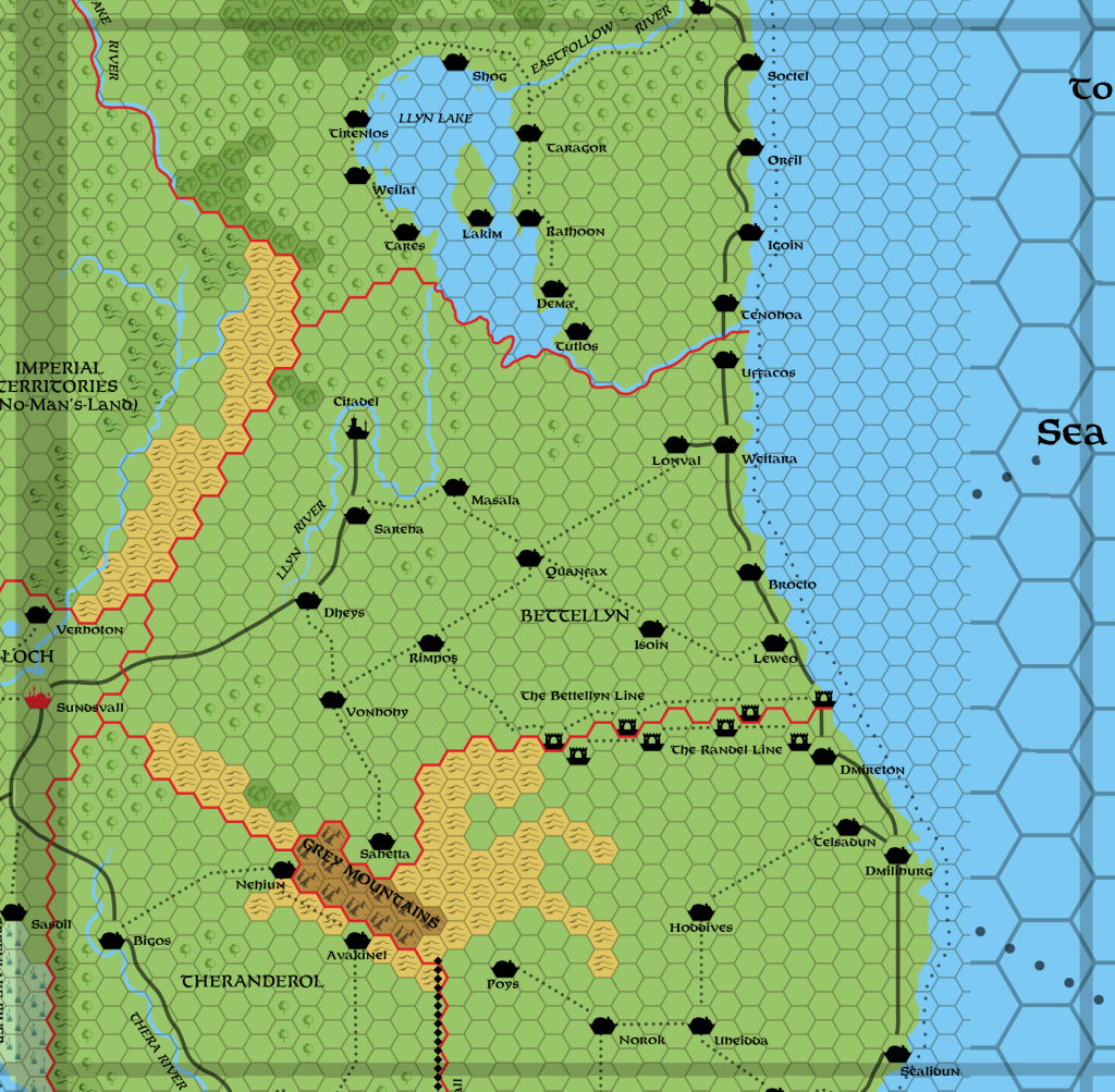
I count roughly 12.25 hexes. 12.25 x 72 = 882. 882 / 10 x 360 = 31, 752 miles circumference. Radius 5,053 miles, diameter 10,107 miles.
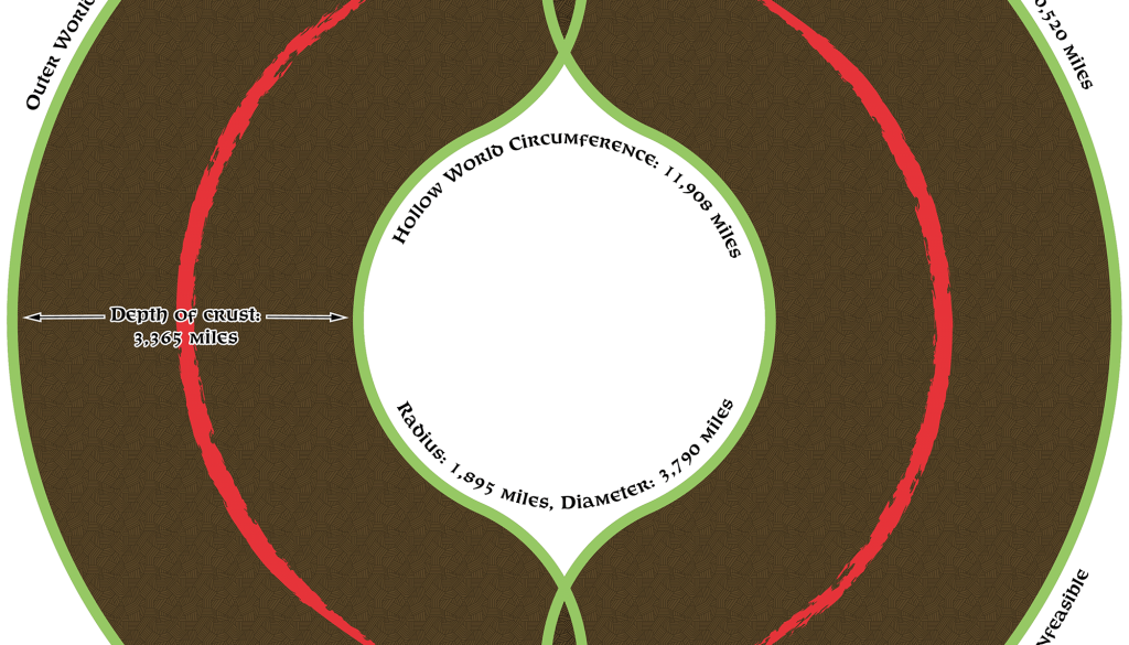
It still seems rather big, but let’s mock it up anyway, just to be sure:
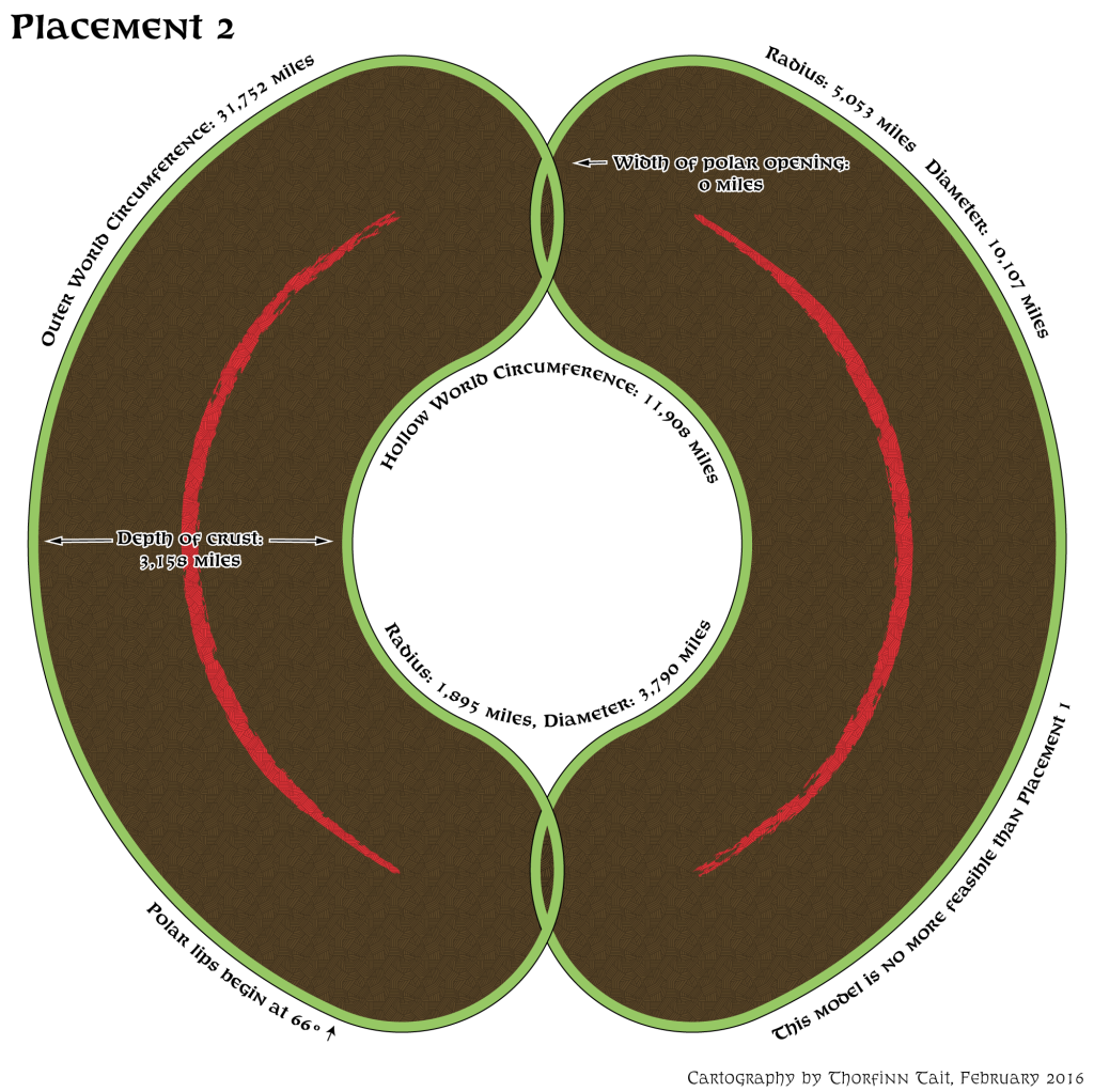
Still no good.
Talk about hitting a brick wall!
Options
I don’t like option 3 (bringing back the polar lips to lower latitudes), which leaves us with just the first two options: further shrink the Outer World, and enlarge the Hollow World. Maybe we can try and make things meet halfway.
We can probably squeeze the Outer World a bit more. These circumference numbers in the thirty thousands were unexpected, because previous fan estimates have been in the twenty thousands, with a Mystara just a little bit bigger than Earth. The true size of the world doesn’t really matter, as long as everything fits, so we can play with this further.
It actually also deals with an issue I had, which is that at 30ºN, the Sea of Dread coast with Karameikos and Thyatis seems awfully tropical. However, shifting latitudes will also result in northern Alphatia and northern Norwold being at a much higher latitude. Perhaps this fits, too, though.
But let’s start with the easier part of this next attempt.
The Hollow World
Back in 2012, there was a great discussion at The Piazza about World Dimensions. We didn’t come to any firm conclusions, due to all of the issues I’ve been working through on this project. But there was a lot of discussion of the Hollow World, which we can draw from here.
Here’s the composite I came up with to measure the extents of the Hollow World’s landmasses:
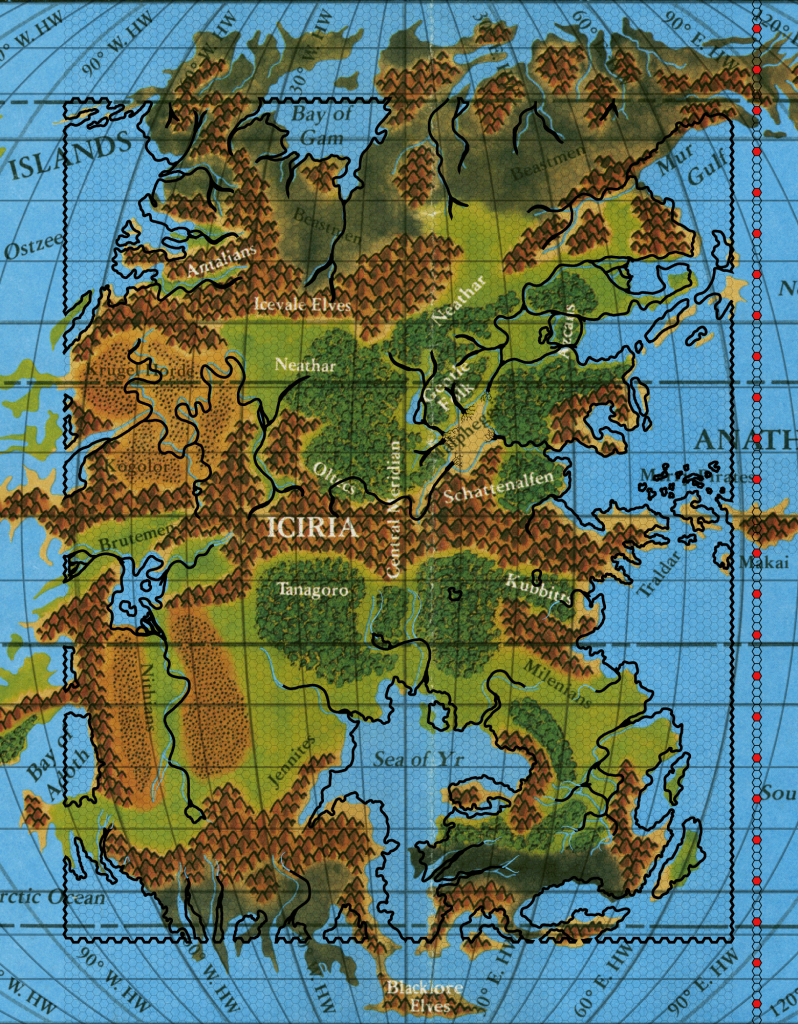
A couple of interesting things to note: the latitudes near the equator are larger north-south than the extremes near the poles; and the map shows 90ºN and S, despite the lack of an actual pole.
Regardless of the marked latitudes, it seems clear from the hex map that all of this terrain is supposed to be on a constant north-south scale. In other words, the closer together lines from 60º outwards can be safely ignored. I’m not at all worried about having to reassign latitudes, either, as it may be a necessary evil in order to get the world working right.
A little hex counting will reveal 62.5 hexes (at 40 miles per hex) from the equator to “90ºN” and 62 from the equator to “60ºS”. The north shows more water, so let’s ignore that and call it 124 hexes. 124 x 40 = 4,960 miles. Or we could think of it as 125 hexes for a nice even 5,000 miles.
At this point in the 2012 map I went on to extrapolate the circumference, assuming these figures stretched from imaginary pole to pole; the “extra” lands could then be folded into the actual polar openings. (Given the above figures, this would be 9,920 or 10,000 miles.)
But that’s not what I’m thinking this time. First, the compressed latitudes are a big clue that these lands are not supposed to extend to the imaginary poles, and therefore are not supposed to fall into the polar openings — at least not very much. Further, my reproduction of the Hollow World map, which “fixed” these squashed latitudes, turning them into regular latitudes, was probably a mistake. I now believe that these regions should be left unstretched.
The biggest point is that I think these lands should largely fit into the unwarped space between the polar lips, i.e. between 66ºN and 66ºS — or at least a smaller area.
We can calculate an ideal area by extrapolating the circumference in the same way we did with the Outer World: by counting hexes and finding out the number of miles per degree. If we do this for the equatorial area, I think we will reach a larger figure than we did before.
I count roughly 8 hexes, so: 8 x 40 = 320. 320 / 10 * 360 = 11,520 miles. (This is also what Hugin came up with in the 2012 thread.)
Unfortunately, this is not helping: the official measurement was 11,908 miles, and our estimate has actually ended up smaller. If that’s the case, we’d be better to go with the official number, because making the Hollow World smaller at this point is simply not an option.
Darn.
Placement 3
So we’re left with shrinking the Outer World. I’m beginning to feel increasingly desperate… Are we going to be able to make this work at all? Keeping Davania in the same Champions of Mystara-based location, I’ve squashed the latitudes as much as I dare to.
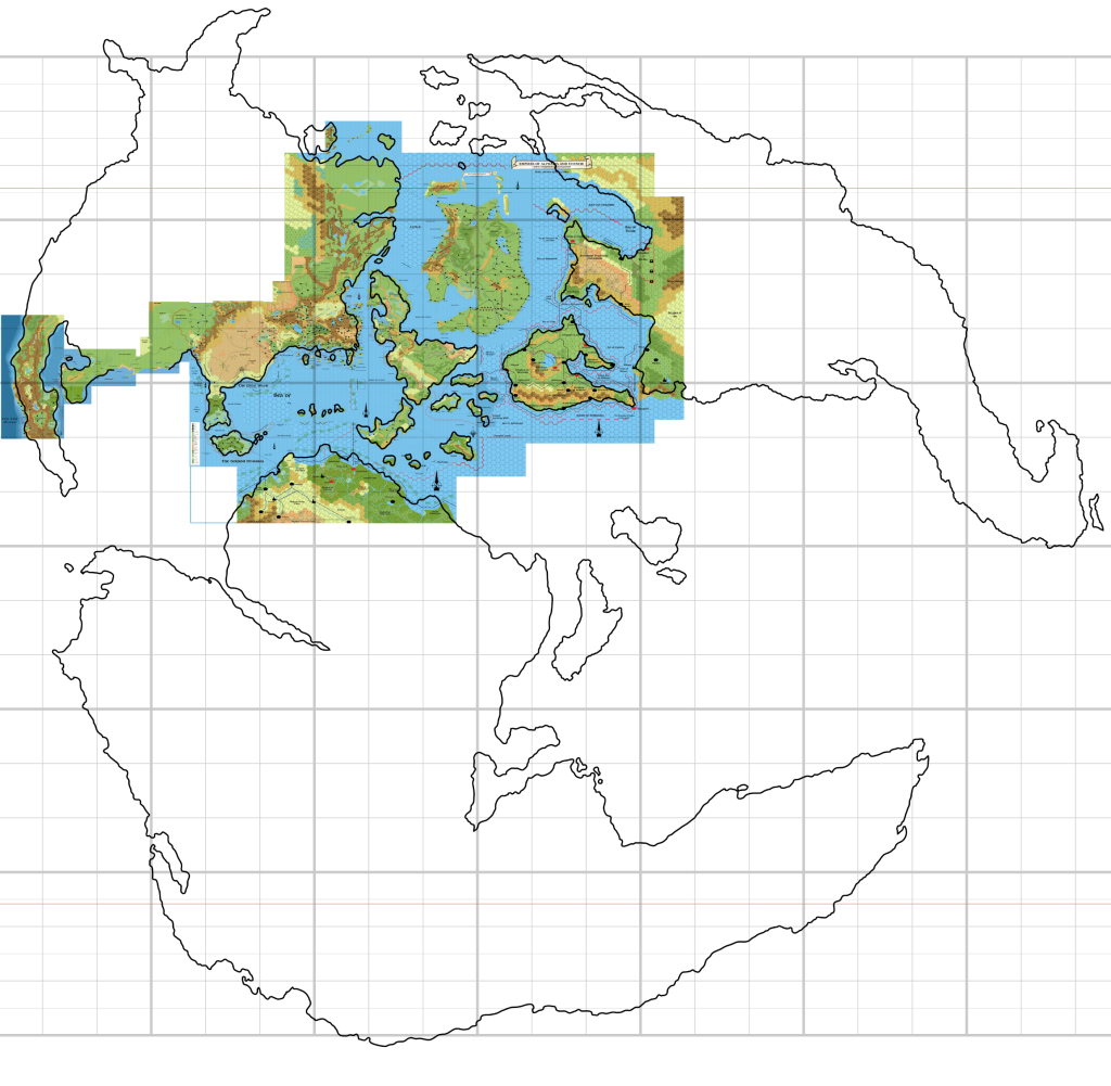
Lands past the red line start to fold into the polar openings, but until around 70º it’s not really obvious that this is starting to happen. Nevertheless, Frosthaven will be squarely within the opening.
Ambur, Ar and Frisland now fall between 60 and 63ºN or so, and Alpha is at about 60ºN too. Farend looks to be almost at 65ºN. Take a close look at the map to see all the other latitudes.
So how does this measure up? Time for some more hex counting:

I count about 10.75 hexes. 10.75 x 72 = 774. 774 / 10 x 360 = 27,864 miles circumference. Better, but is it going to work?
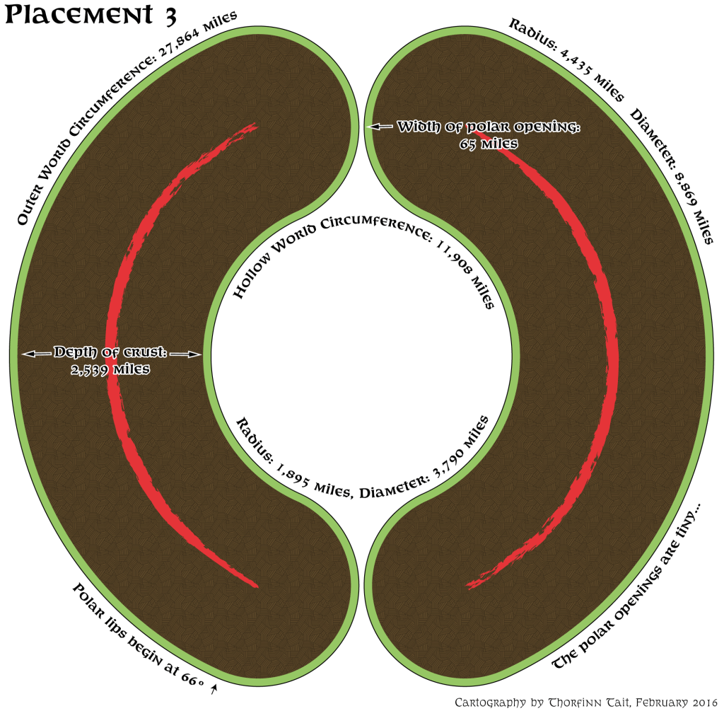
We do at least have polar openings this time, but I don’t know if I’d call this working.
And yet I can’t see shrinking the Outer World any more than this — we’re already going into dangerous territory by shrinking it this much.
What other options could there be?
Should we move the equator north to the PWA2 location? I somehow doubt that would allow us to shrink the world much more, if at all, because southern Davania can’t all be shunted into the polar openings.
But what else is there to do?
Should we enlarge the Hollow World? We may be able to squeeze another thousand miles or two in there, in order to open up the polar openings a bit. That may be the best bet — and I can stretch the northern and southern areas to compensate a little, or rather leave them as they are on my reprojected Hollow World map.
Any thoughts on all of this?
14 February 2016 @ 8:41 pm
One remark to this
You keep the curvature in the Polar opening as round as presented on the HW set maps.
However as I look to polyps, which resemble the shape of the Megalith that Mystara is, these curvatures aren’t thus rounded. They seem more flat like the outer World…
To resolve this just push in the circle make it more..eh…egg-shaped? …
whatever..I suppose you catch my drift
14 February 2016 @ 10:59 pm
There’s an ulterior motive to keeping these as regular as possible: it will make them a little easier to map. As it is, they’re going to be a big headache, so the less irregularity we can introduce here, the better, as far as I’m concerned. 😉
15 February 2016 @ 3:16 am
I agree with Robin: if you modify the shape of the polar openings you’ll have the opportunity to increase the latitude of their borders to values greater than 66° N (or S).
The polar opening themselves are not very interestin from a gaming point of wiev: they are just dark, frozen, wind-swept holes covered in magical clouds and filled with anti-magic: really, not much to see and to do there.
If you like to keep shapes as much regular as possible why not choosing a straight tunnel which ends up into two smaller circular openings? I made a rough sketch here to explain better what I mean:
https://drive.google.com/file/d/0B_huOOfYqf0BTDBjejZSVEJuLVU/view?usp=sharing
In this way you can set the geometry of the openings as you see fit. The circular ending will help keeping mapping and projections a relatively easy task. Outer World and Hollow World landmasses could be arranged so that they do not enter the straight section, which is entierly covered by sea.
Whit this approach who cares if the straight section of the openings is 500 miles, 1000 miles or 2000 miles long?
On another matter, IIRC when we discussed the size of Mystara it came out that, if the Mentzer/hexed maps are part of a global equirectangular map then the vertical size of the hexes always represents the same distance, irrespective of the latitude (because latitudes on an equirectangular map are evenly spaced).
Now, we have an uniterrupted hexes count from the Equator up to Froshaven, which should be pretty close to the Arctic Circle (IIRC PWAIII says that the summer polar ice shelf is 600 miles north of Qeodhar). With this in mind I think that the size of Mystara will come out from this hexes count, irrespective of what the other official supplements say.
On a final note, if Mystara comes out to be a very big planet then, in order to keep the same size of the Hollow World (whose mapping is more consistent among the various official sources) then the crust thickness has to be increased. This is not a major modification, in my opinion, as it has very little impact on the rest of the setting. Moreover, this is another “pro” point versus the introduction of a straight section in the polar openings in order to avoid too much distortion to the Outer World map.
Just my thougths, feel free to implement or discard them as you like. 😉
17 February 2016 @ 10:42 pm
You’ve persuaded me, Michele! You and Paul Dupuis both proposed this, so I’m going to try it out in my next article. The model I’m using will allow the polar lip to be moved up to 76º in the Outer World.
I agree completely about the crust — it’s the last thing to be worrying about at this point. Your alternative way to measure the size of the planet is interesting. I’ve already got three placements in the works for the next article, so please look at them and see if any match your idea here. However, I don’t think it’s going to be possible to have Frosthaven outside the Arctic Circle, actually. But I don’t think it should be anyway. After all, Farend is repeatedly said to be at 60ºN, and it’s about 700 miles south of Frosthaven’s southern coast. Surely it must be in the Arctic Circle, and quite possibly even in the polar opening — not very far in, but I think it’s further north than 66º.
15 February 2016 @ 4:40 am
Thanks for these – very helpful.
I’d personally prefer a solution that didn’t push Norwold any further north – would the alternate equator location and a ‘squashed’ Davania help?
I think the hollow world could accommodate a few extra miles.
Also – from memory – isn’t the polar area shrouded in fog? in which case an opening of only 65 miles in width might be fine.
17 February 2016 @ 10:36 pm
Surely the name suggests it should be quite far north already? 😉
I actually agree with you. In my next article, I will detail three more placements, all of which place Farend at 57º, 60º, and 63ºN. These are all close to the official latitude (60ºN).
It seems that PWA2’s equator does indeed help with this, yes. But I will not be squashing Davania. The expansion of Skothar and the squashing of Davania are two of my pet peeves, actually!
You’re quite right about the polar area. Paul Dupuis pointed out the same thing on Facebook.
15 February 2016 @ 5:28 am
I have this inner favoritism to the outer surface features and sacrificing the hollow surface.
Note: I’d like to see the cross sections mark the latitudes for reference.
Question: could we make the depth thinner?
17 February 2016 @ 10:32 pm
You’re not alone, but I’m not going to sacrifice the Hollow World to save the Outer World. 😉 This has also come up before, but I don’t consider the Hollow World to be expendable in the least. Besides, its cartography is much cleaner than the Outer World already! I wouldn’t want to mess it up.
15 February 2016 @ 7:07 am
By increasing the size of the hollow world would that put the shadowlands closer to the Hollow World Lava in the center? I think the cavern of the stars then makes some more sense, especially since the gravity splits closer to the middle of the planet.
17 February 2016 @ 10:31 pm
That was close to my initial reaction to increasing the size of the crust the last time we discussed these issues at The Piazza: http://www.thepiazza.org.uk/bb/viewtopic.php?f=22&t=555#p5567
15 February 2016 @ 4:44 pm
I think it’s because you are trying to fit the entire OW land masses into the 90 deg N & S band.
The HW Maps may assist here, specifically the OW Arctic and Antarctic Caps; 90 deg OW and 90 deg HW do not match up, so you have 30 deg leeway in the Lip to play around with. The 90 deg N OW line should be below the Nentsun peninsula.
This should save you having to shrink the OW.
17 February 2016 @ 10:28 pm
I am? Actually I’ve been folding over quite a bit of land into the polar openings pretty much in every map. Remember that 66º is the start of the lip in this model, so shortly after that latitude things start to fall into the polar openings. If you compare my mock-ups (which unfortunately are out of date now — I’m working on new ones), you should see that roughly the right amount of land if falling into the openings.
The confusion likely stems from the latitudes marked on the Hollow World Set maps. I’m not using those; I’m using latitudes as if Mystara were actually a spheroid. Yes, I know these are not true latitudes, because latitude is defined by angle, so in fact some point shortly after 66º would be 90º. But using those latitudes is useless for our purposes, because it rules out the use of real world GIS software for mapping. On the other hand, if we use spheroid (or ellipsoid) latitudes, we can use software to keep track of everything up to 66º. (The rest will have to be done manually, or by using the 3D model.)
17 February 2016 @ 4:51 am
Well, we’re back to this topic again, eh Thorf?! LOL
(Previous discussion referenced above by Thorf found here: http://www.thepiazza.org.uk/bb/viewtopic.php?f=22&t=7369)
You are fairly close to what I came up with in that thread; the main differences being derived from using different maps. It looks like the one I was using had the equator placed a little higher and based on PWAII’s placement of the equator. Using the map I did, I came to a circumference of 25,920 miles.
My solution there was to use 1° = 72 miles. It worked very well with the other map, but your map seems to have more hexes because the Equator is lower. You can see the equator marked on your map at about 5° North, again from PWAII I believe.
So here is my suggestion: raise the positioning of the equator, let each 72 miles be 1°, count hexes to see where the latitudes lie. Alpha actually ends up being at ~59° N using this scenario and Thyatis at ~33° N!
I think that re-positioning the equator to the PWAII position is a viable option #4. Additionally, using this method allows the Hollow World to use the 32 miles per 1° latitude and still have sufficient openings for the poles.
It may not be the perfect solution but it sure works for me.
17 February 2016 @ 10:21 pm
Hi Sheldon!
Hehe, yes we’re back to this one — hopefully for the last time, this time. 😉
So far, the Princess Ark/Hollow World Set equator seems to be more popular than PWA2’s. But I will certainly explore the idea of using PWA2’s equator in my next article. It would certainly result in a smaller world.
On the other hand, I’ve never been enamoured of the 1º = 72 miles thing. I don’t really care about 72 mile per hex maps, because hexes don’t work well at that scale anyway. For me, getting the map looking right is more important than the precise mathematics. That said, it’s looking like 10.5 hexes per 10º would make a very nice model.
But since you’ve proposed it (now and in the last conversation 🙂 ) I will also include it in my next article. I should warn you, though, that since my maps are based first on 8, then 24, then finally 72 mile per hex maps, and since the original 72 mile per hex maps were essentially useless, it’s not going to fit quite like you expect.
I don’t really want to play further with the Hollow World. Since the official figures seem to work, I’m going to go with them. Another issue is that I really don’t want to shrink it any, as the size disparity is already a problem.
Great to see you here, by the way! 😀
18 February 2016 @ 12:58 am
Thanks, Thorf!
I know you don’t like the 1° = 72 miles approach because you’re not a fan of using 72 mile hex maps, but to be honest, the entire time I was exploring this option I was using 24 mile per hex maps. So I don’t think the 72 mile hex maps have anything to do with it, other than the fact that 72 is divisible by 24 and 8, which makes it very simple to use at those scales too.
So just to reiterate, using 72 mile per hex maps has nothing to do with it. I did most of my counting on a 24 mile hex map, using one hex equals 1/3rd of a degree. If using 8 mile hex maps, each hex is 1/9th of a degree. I just don’t want it overlooked because the 72 mile per hex maps are not the greatest to base anything on (and on which point I certainly agree with you). The size of hex map is really irrelevant. I think you’ll find it works, better than you think anyway, when you use your 24 mile maps.
I pretty much agree with you on the Hollow World. The official size seems to work well enough even though I came up with a slightly smaller figure.
I had a diagram drawn up showing a cross-section of Mystara using my figures and it worked very well. Here it is on the Vaults: http://www.pandius.com/mystarastructure.jpg (don’t make fun of my crude, non-techy, pencil-sketching, cave art 🙂 ). There are some errors on that map as well; “Isle of Dawn” is supposed to be “Isle of Dread plateau”, and, “Autumn Solstice” is supposed to be “Winter Solstice”.
Notice that I also had flattened the polar openings as suggested by others above. However, I understand your hesitation with that approach.
Finally, this does push southern-most Davania (farther) into the polar curvature. This shouldn’t be too much of an issue though.
Thanks for tackling all these issues, Thorf! You know we love seeing the work you’ve produced over the years!
18 February 2016 @ 1:10 am
It’s not that I don’t like it — I understand that it could be rather useful, and I agree it’s nice to be able to count latitude with hexes. But I’m not sure that it’s worth shrinking the world to enable this feature. (If we were designing a world from scratch, I would absolutely do it, though!)
I would never make fun of a hand-drawn diagram. I could never do this stuff without my computer, so I have the utmost respect for anyone who can do it by hand.
In any case, I’m going to try applying placements 5 and 6 from the article I just posted to the 3D model. That should make it much easier to choose between them and the others. I think you are definitely right that PWA2’s equator is the one to go with, because the other one just ends up with a world that’s far too big.
Lining Up Mystara I – Thorfinn Tait Cartography
19 February 2016 @ 11:56 am
[…] Up Mystara IX, Lining Up Mystara X, Lining Up Mystara XIII, Lining Up Mystara […]