Let’s Map Mystara 1986
Preface: I began work on this article in May 2019, right after finishing the 1985 article. That one took more than a year, but this one has taken even longer — almost three years. During that time I have also gone back to the start, revising the whole series from 1981 to 1985, adding in various things I had missed back in the early days of the project. Now, at last, I am ready to present the next chapter…
After the major revelations of the previous year, 1986 was a relatively quiet year for Mystaran cartography, with only four or five products including new maps. Only one presented a new area, while others provided further development of existing nations.
But if that description makes it sound like little was added, in fact that couldn’t be further from the truth. Let’s delve in and see what happened.
First up: B10 Night’s Dark Terror, which added extensively to Karameikos.
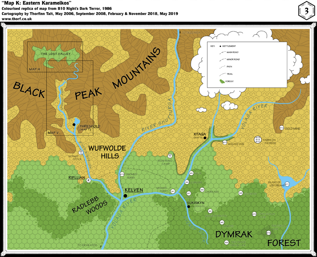
Map 40: “Map K Eastern Karameikos” from B10 (February 1986)
From the Atlas of Mystara:
B10 Night’s Dark Terror is surely one of Mystara’s best-loved adventures. It also includes some of the most detailed maps of Karameikos in any official source, even providing ridge lines for the Black Peak Mountains to the north of the realm.
Additions
- Islands — The Island of Lost Dreams is labelled on the map, though the isle itself is hidden beneath its label. See Textual Additions for more on the Island.
- Lakes — Threshold is shown to be on the southern edge of a lake. This is the first appearance of the lake on a map, although it previously appeared on the Expert Set Threshold map and in the text. The lake remains nameless for now.
- Mines — The Gold Mine here is the first mine to be marked on a map of Mystara. It lacks a symbol, instead having a key number.
- Mountains — The Black Peak Mountains have been given ridge lines, although it is unclear exactly what they are intended to mean. (See this thread at The Piazza for discussion of this issue.)
- Plateaus — There is an area with plateaus and ravines along the flow of the Volaga River in the east.
- Rivers — The Syereb River is entirely new, as is the river system around the lake with the Island of Lost Dreams. The names Volaga River, River Shutturga, River Windrush, and River Foamfire are all new names given to existing rivers, but see also Revisions below.
- Settlements — Sukiskyn and Xitaqa. A wealth of other features is marked throughout the map, but with keyed numbers and letters rather than symbols; it’s unclear from the map alone which of these may be settlements: Rifllian, Sielo, Ilyakana, Hokol, Cherkass, Segenyev, Viper Goblin Lair, Wolfskull Lair, Red-blade Goblin Lair. There are also smaller or more temporary locations such as camps and attack sites: Bandits, Gnomes’ Ferry, Iron Ring Camp, Misha’s Ferry, Scange Attack, Tombs on the Ridge, Wolves’ Den.
- Terrain — Wufwolde Hills, Radlebb Woods and Dymrak Forest are all named for the first time, although of course the terrain itself appeared on maps as early as 1981.
- Trails & Roads — An extensive system of roads and trails are shown throughout the map, divided into an unprecedented four levels: main roads, minor roads, paths, and trails. All but the main road (Krakatos-Kelven-Selenica) and part of the Kelven-Threshold road are new.
- Waterfall — Although it’s unlabelled and the symbol lacks an entry in the key, the River Foamfire’s course is interrupted by what seems likely to be a waterfall as it leaves the mountains and enters the valley.
Revisions
- Rivers — The Volaga River was previously labelled River Highreach, all the way back in 1981’s X1 map. It also wasn’t clear which of the sources was considered the main river, but B10 explicitly shows it to be the easternmost source. The River Foamfire has been extended up through the mountains to the Lost Valley. The courses of the rivers remain largely the same, though they vary by as much as two or three 3 mile hexes in places. The confluence point between the Windrush, the Shutturga and the Volaga has been moved approximately 4 miles north-northeast.
- Spelling — Kelven; previous maps had both Kelvin and Kelven, with the former slightly more prevalent, but B10 uses Kelven throughout.
- Terrain — The terrain on this map lines up reasonably well with that of previous 6 mile per hex maps, although not perfectly. Revisions are assumed to be the result of being able to show more detail at the larger scale used in this map.
Hex Art & Fonts
- Fonts — Hand-written text in a clear, architect-like style.
- New Symbols — Ridgelines (lines drawn on outlines of mountainous areas), Waterfall (three splashing lines breaking a river’s course), Hill edges (dotted line between hills and plains); Main Road (dashed line), Minor Road (alternately dashed/dotted line), Path (small dashed line), and Trail (dotted line) are not exactly new but the hierarchy defined here is unique to this map.
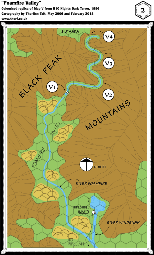
Map 41: “Map V — Foamfire Valley” from B10 (February 1986)
Additions
- Mountain Passes — The pass leading to the Lost Valley is shown at a new level of detail.
- Terrain — The Foamfire Valley is named here for the first time, and the blanket hills of the smaller scale map are divided up into several clumps on the plains of the valley floor.
Revisions
- Lakes — The lake north of Threshold is shown in more detail, though it remains unnamed.
- Mountains — The ridges of the Black Peaks on this map are slightly different from the other maps, and don’t quite match.
- Rivers — The River Foamfire is shown in more detail.
- Terrain — The Lost Valley previously appeared on 6 mile per hex maps, but is here labelled Hutaaka for the first time.
Hex Art & Fonts
- Fonts — Hand-written text in a clear, architect-like style.
- New Symbols — Compass Rose (circle with arrow inside, “North” written alongside).
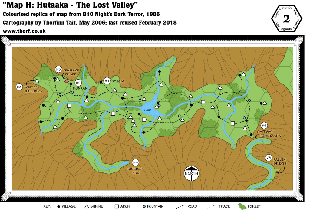
Map 42: “Map H — Hutaaka” from B10 (February 1986)
Additions
- Lakes — The unnamed lake in the middle of the valley is new here, as is the tiny Singing Pool in a side-valley to the south.
- Mountain Passes — While it’s not exactly a pass, the Gateway to Hutaaka marks the entrance to the valley.
- Rivers — The extensive river network inside the valley appears here for the first time.
- Settlements — Unnamed villages, shrines, arches and fountains appear throughout the valley. The Vault of the Elders and the Temple of Pflarr are named shrines. Ronkan and Byxata appear to refer to villages — likely those closest to their H2 and H1 tags.
- Terrain — The exact shape of the valley and its terrain are detailed here for the first time; previously it has appeared to be all hills.
- Trails & Roads — The whole valley is served by a very efficient system of roads, as well as a single trail in the west.
Revisions
- Mountains — Again, the ridge lines shown on this map do not quite match up with the other maps.
Hex Art & Fonts
- Fonts — Hand-written text in a clear, architect-like style.
- New Symbols — Shrine (unfilled triangle with rounded corners; a red-filled triangle seems to represent a Temple), Arch (unfilled square with rounded corners), Fountain (unfilled circle). The Compass Rose is the same as the previous map, but with “North” written inside the circle below the arrow.
Map 43: “Players’ Map” from B10 (February 1986)
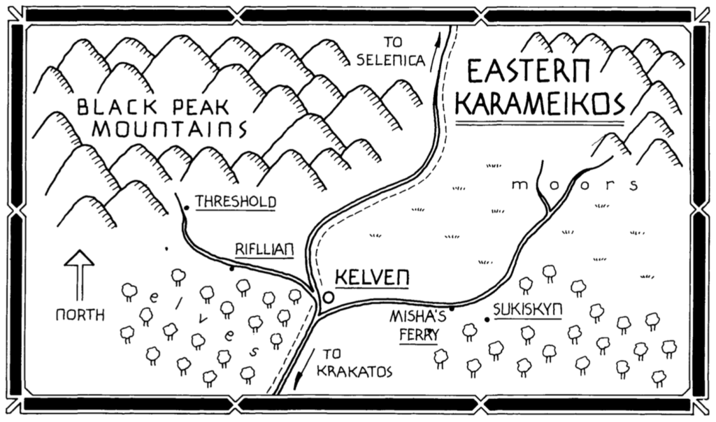
Although this simple map may at first glance seem to provide no new information after the hex map, in fact it includes two significant additions and one other point of interest.
Additions
- Races — Elves are marked as living in the Radlebb Woods west of Kelven.
- Terrain — The area north of Sukiskyn is here marked as “moors”. The hex map has hill hexes in this area. Note, however, that since B10’s authors were British, “moors” most likely refers to hills: “a tract of open uncultivated upland, typically covered with heather”, according to the dictionary. The US English sense of marsh or fen is likely not intended here.
Revisions
- Rivers — On this map, the Windrush meets the Shutturga shortly before the confluence with the Volaga. In other words, the idea that the three rivers do not all join at the same spot appears here for the first time.
Hex Art & Fonts
- Fonts — Hand-written text in a clear, architect-like style.
- New Symbols — Moors (grass-like dashes).
Map 44: “Island of Lost Dreams” from B10 (February 1986)
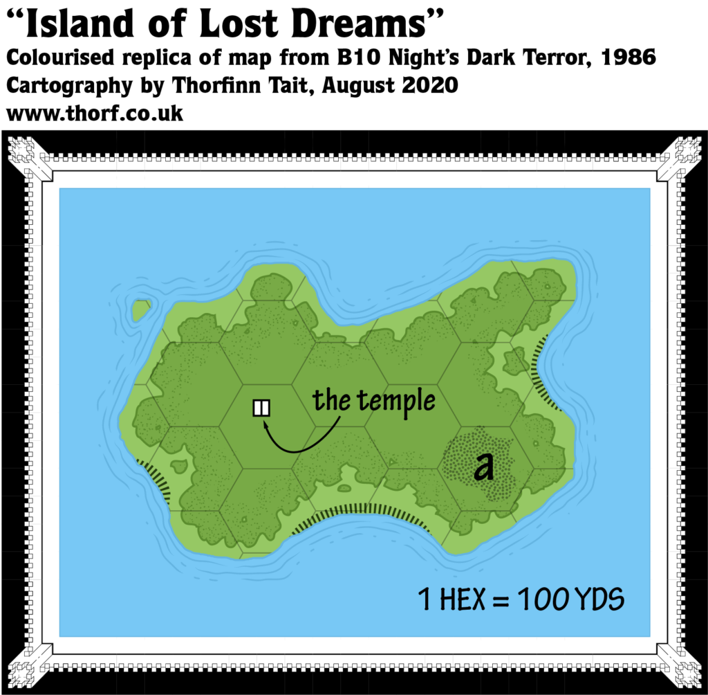
Although in truth this map is a bit too large scale to consider for this project — the island is less than one third of a mile long, and thus barely appears even when added to the Eastern Karameikos 3 mile per hex map — after consultation with the community I decided to include it.
Additions
- Islands — The precise shape of the Island of Lost Dreams in the Lake of Lost Dreams is presented here. Its precise location in the lake is not clear from this map.
- Settlements — A single unnamed temple. This is too large scale to appear on any of the smaller scale maps, and therefore beyond our consideration.
Hex Art & Fonts
- Fonts — Hand-written text in a clear, architect-like style.
- New Symbols — Cliffs (dashes along the coast), though there is no key to define this art.
Textual Additions (B10 1986)
- Bridges — There is a bridge crossing the Syereb River directly west of Sukiskyn; in fact, the homestead is located at a bend in the river (pages 7 and 9). There are four bridges on the path to Hutaaka: two intact, across the Gorge and the High Bridge; and two broken, the Fallen Bridge and before the Gate to Hutaaka.
- Camps — A number of camps are marked in B10. These are no different from lairs, really.
- Bandits (W3) — A camp with 5 bandits, including “Bandit Leader” Fyodorll. (Page 12)
- Iron Ring Camp (WE7) — This camp seems to be too temporary to warrant marking on the map. (Page 30)
- The Scange Camp (WE12) — A total of 26 bandits including their leader, Hrothgar. (Page 33)
- History — The Hutaakan Empire “extended over the lands now covered by northern and eastern Karameikos”, “many millennia” ago. Their realm “expanded from the valley of their birth out onto the lowlands”, where they conquered the “primitive human tribe” known as the Traldar. “Hutaakan civilisation flourished both inside and outside the valley. As it was reaching its zenith, the lowlands were invaded by gnoll hordes.” At this point the Hutaakans withdrew to their valley with their human minions. Subsequently, the Traldar revolted, beginning “years of bitter inter-racial warfare” in which “most of the valley’s population perished”. The struggle continues to this day. (All page 4.)
- Islands — Map W11 shows the exact shape of the Island of Lost Dreams, but since the island is only about 550 yards long (at a 100 yards per hex scale), it’s somewhat beyond the scope of this project. The Temple marked on the map is referred to as “Ancient Building” in the text; it’s said to be in the centre of a grassy clearing in the woods (page 17). The “a” on the map is a pixie village (population 14). The pixies are known as the “Ilya”. (Pages 16-17)
- Lairs — The pre-adventure state of the lairs detailed in B10 should be as follows:
- Bald Dog Lair — This orc lair is said to be “Underground in Zargash Mountains (not on map)” (PSVI).
- Dark Web Lair (W12) — These orcs’ lair is said to be “on the far side of the mountain spur” from the Gold Mine (page 17). There are 22 orcs (page 18).
- Death’s Head Lair — “Caves (not marked) overlooking the valley of the Foamfire River” are the lair of the Death’s Head gnolls. (PSVI) There are 175 gnolls, including gnoll chieftain Gragszt, who is also described as their “warlord”, as well as 4 ogres (page 41).
- Red-blade Lair (W9) — Before the adventure, this lair was home to 51 goblins, including their “king”, Gnhass. This includes 3 noted to have fallen at Sukiskyn before the adventurers arrived. (Pages 7 & 10)
- Viper Lair (W10) — Since it is noted that 3 goblins were killed at Sukiskyn, the tribe originally consisted of 20 goblins. Their leader is unnamed. (Pages 7 & 10)
- Wolves’ Den (W17) — a “den of caves in a rocky outcrop by the Volaga river”, home to 2 werewolves and 11 wolves, led by Bailakask (page 23).
- Wolfskull Lair (W16) — Pre-adventure, 29 goblins, including their “king”, Kloss. (Page 10)
- Lakes — The Lake of Lost Dreams, in the midst of which the Island of Lost Dreams lies, is named in the text (page 16). (See also Islands above.) The (still nameless) lake on whose shores Threshold sits has rather different sizes: the 3 mile per hex map has it about 8 square miles, while the 2 mile map has it about 6 square miles, and slightly further north. The Atlas tends to view larger scale maps as the best sources, so I have gone with the smaller lake from the Foamfire Valley map.
- Mines — The Gold Mine (W12, pages 17-19) is owned by a gnome called Vissaryon, who operates it with his brother Tekaryon and 12 dwarf miners. (Pre-adventure figures.) It is also home to the Dark Web orcs. (See Lairs above.) There are Hutaakan ruins in the caves.
- Races — B10 introduces a large range of named tribes and clans — far more than any previous module, and they are far more detailed, too.
- The Callarii elves reside in and around the village of Rifllian. Their symbol is a white horse. (Page 5) They also live elsewhere in the Radlebb Woods; Callarii was “their epic heroine”, and appears in their symbol as a “sad elven woman on a white horse” (both PS VI).
- A second clan, the Vyalia elves, live in “tree-houses in forest S.E. of Lake of Lost Dreams (not on map).” (PS VI) This last comment can be taken two ways: either the tree-houses are not shown on the map, or the Vyalia elves live off the edge of the map. It seems reasonable to assume it’s the former.
- The three goblin lairs on the map are given goblinoid names in addition to their common tongue names: Red-blade (Gnhasska) goblins, Wolfskull (Kloss-lunk) goblins, and Viper (Jaggadash) goblins (page 7, PS VI). These names are apparently based on the goblin “kings” leading the groups: Gnhass and Kloss (page 10). A fourth tribe is the Yellow-fang (Faz-plak) goblins (PS VI). (See also Lairs above.) These goblins account for the Goblins label in the Dymrak Forest area on previous maps.
- Two orc tribes are mentioned: the Black Web (Nyy-akk) orcs (page 17 & PSVI) and the Bald Dog (Pftark) orcs (PSVI). The Black Web orcs can be found in the Gold Mine, while the Bald Dog orcs are a random encounter — “a raiding party from the mountains” (PSVIII). (See also Lairs above.) These orcs may account for the Orcs label near these mountains on previous maps.
- The Death’s Head (Galt-kalat) gnolls (PSVI) claim most of the Foamfire Valley as their territory: “A few miles from Threshold, the route along the Foamfire enters the lands claimed by the Gnolls of the Death’s Head. … Further upstream, the gnolls’ territory ends at a majestic waterfall where the Foamfire crashes down from a narrow mountain pass.” “The lands of the Death’s Head gnolls begin at the point where the Foamfire valley narrows north-west of Threshold.” (Page 40) (See also Lairs above.)
- Rivers — The rivers of Karameikos are quite a focus in B10, with quite a lot of mentions in the text. PSI makes it clear that B10’s conception of the confluence of the rivers Windrush, Shutturga and Volaga is indeed at the same place, and that Kelven is located there — agreeing with the hex maps but contradicting the Players’ Map.
- Foamfire — “The Foamfire river is not navigable by watercraft.” (Page 38)
- Volaga — The first place upriver from Kelven where the Volaga River can be crossed is at Misha’s ferry, where a trade route crosses the river (page 6). “Upstream from Sielo, the Volaga river may be crossed easily at the ford, or by swimming characters, or those on horseback.” (Page 24)
- Windrush — This river is navigable from Threshold to Rifllian and beyond to Kelven. (Page 32)
- Settlements — B10 introduces not just towns and villages but also homesteads and ruins; there are homesteads and forest lumber-camps east of Kelven (page 5). Many of these are destroyed during the adventure, often before the PCs can visit, meaning that their status on a map will depend on whether it is pre-adventure or post-adventure. Since the Atlas in most cases deals with the pre-adventure world, I am marking these accordingly.
- Cherkass (W6 on the map) is a homestead like Sukiskyn, but it is destroyed during the adventure. (Page 15)
- Gnomes’ Ferry is a ferry and hostelry on the Shutturga river run by 5 gnomes (page 41).
- Hokol (W7 on the map) is another homestead like Sukiskyn, but it is destroyed during the adventure. (Page 15)
- Kelven is “a thriving frontier town that has grown up rapidly, following its establishment at the point where the rivers Windrush, Shutturga, and Volaga meet” (PSI). It has a wharf where riverboats dock, and is therefore explicitly located on a river — the Volaga River, to be precise (page 6). This implies that it is either located between the Volaga and the Shutturga, or else it straddles the Shutturga (surrounding a bridge or bridges for example) so that it sits by all three rivers. It’s worth noting here that since its original appearance on Karameikos maps it has been depicted as being between the Volaga and the Shutturga. Page 32 implies that there is river traffic between Threshold, Rifllian and Kelven along the Windrush river. Regardless of the exact location and configuration of Kelven, it seems clear that it has access to all three rivers.
- Ilyakana (W4 on the map) is a lumber camp. It is destroyed by goblins during the adventure. Population is uncertain, though “most of the people there” were said to be killed, with four survivors, suggesting a population of at least ten. (Pages 12 & 15)
- Misha’s Ferry is a single cabin by a jetty on the Volaga river, with a single resident (Misha) who lives with her pet bear. She is killed before the PCs can meet her. (Page 6)
- Rifllian is a village, populated by Callarii elves (PS VI). “Rifllian is a small elven village of 170 inhabitants on the western bank of the Windrush river. The village is an outpost of the Callarii elves…” “Most of Rifllian’s inhabitants are Callarii elves.” (Page 32)
- Segenyev (W8 on the map) is another homestead like Sukiskyn, but it is destroyed during the adventure. (Page 15)
- Sielo (W5 on the map) is another lumber camp. Like Ilyakana, it is attacked and destroyed during the adventure. Population is unknown. (Page 15)
- Sukiskyn is “one of several fortified homesteads in the wilderness east of Kelven”, population 12 humans at the start of the adventure (PS III).
- Threshold “lies on the shores of a small lake” (page 34), though the town map in Expert 1983 shows that it is slightly removed from the lake; B10’s town map has the lake cropped out entirely as it is more zoomed in on the town itself. (See Analysis below for more on this.) “Built primarily of wood (a major resource in the area), it is home to about 500 humans and 50 demi-humans.” (Page 34) This is exactly in line with previous figures. “Threshold is ruled by … Patriarch Sherlane, from his lakeside castle of Tarnskeep.” (Page 34) This also matches Expert 1983, where Tarnskeep appeared by the shore of the lake on the map of Threshold. Fogor Isle is named for the first time (page 35 as well as poster map). Locations within Threshold itself include:
- Cardia’s Carpet Service — outside the town hall. (Page 37) This is another item originally from Expert 1983.
- The Crossed Swords — “a deserted inn on the wharf side of Fogor Isle”, “home to a vicious troll”. Also known as the Inn of the Crossed Swords and the Crossed Swords Tavern. (Page 37)
- Gates — north and south, again the same as Expert 1983.
- Hook and Hatchet Tavern — “by the old town wall”, frequented by the town guard (page 36).
- Northbridge — one of two stone bridges linking Fogor Isle to the rest of Threshold. (Page 36)
- Southbridge — not actually named in B10, but this seems the likely name for the second bridge linking the town with Fogor Isle.
- Temple — “an impressive stone building near the town hall”. Always occupied by 20 clerics, with spells up to 4th level available. (Page 37)
- Thieves’ Guild — on Fogor Isle, as in Expert 1983. (Page 36)
- Town Hall — also named on Expert 1983 map, referenced again here. It is “one of the few stone buildings in Threshold”. It houses the Clerical Court, as well as a vault to store valuables. Weapons not allowed inside the town gates (anything but swords and daggers) are also kept here. (Pages 35-37)
- Wererat Hideout — the lair of 4 wererats and an Iron Ring hideout (poster map and page 38).
- Tombs on the Ridge (W13-15) are “three ancient burial mounds, standing on a prominent ridge” (pages 19-20).
- Xitaqa was marked on the map, but in the text is revealed to be the ruins of an “ancient Hutaakan settlement” (pages 4-5). The Yellow-fang (Faz-plak) goblins as well as the Bloodhead (Vlackkag) hobgoblins have their lairs here (PSVI). “Between the northern bank of the river and the escarpment on which Xitaqa stands is a level plain.” (Page 24) “The rambling, ancient, Hutaakan settlement of Xitaqa was built in a knot of winding, steep-sided, gullies eroded into the escarpment above the Volaga river.” (Page 25)
- Terrain — B10 added a number of features to the by-now-familiar terrain of Karameikos:
- The Lost Valley is also known as the Lost Valley of Hutaaka, and Hutaaka — The Lost Valley. Page 4 even notes that the name of the race is taken from the name of the valley, “where they originated”.
- The references to moors in B10 all seem to confirm the interpretation of the word as British English. (Pages 5, 23 and 30.) Horses live there along with Loshad the Chevall, and are described as “galloping away over the moors” (page 30) — hardly a fitting description if the word is taken to mean “fen” or “bog”. In any case, as of 1986 there is no special map symbol for moors — note that the Players’ Map just uses a grass symbol, while the DM’s maps have hills — so for now let’s just use the label.
- The Zargash Mountains appears to be the name of the spur of the Altan Tepes featured in the far east of the 3 mile per hex map, with the Gold Mine. (Pages 16 & 17)
- The Petrified Forest, deep in the Dymrak Forest, is “a dismal valley smitten centuries ago by a magical blight that turned every living thing — plant or animal — to stone” (page 20).
Analysis
The 2 mile per hex maps do not fit perfectly with the 3 mile per hex map. I already noted that the ridge lines don’t line up, but in fact neither do the mountains themselves, nor the rivers, nor even the settlements where marked. For example, there’s no clear way to line up the Foamfire Valley map with the Eastern Karameikos map: the position of Threshold is different; the lake north of Threshold is a completely different shape and size; the rivers don’t follow the same courses; and the mountains don’t line up well. Compounding things, if the southern mountains are placed to fit as well as possible, the northern mountains are then completely out of sync.
All in all, it’s a bit of a mess.
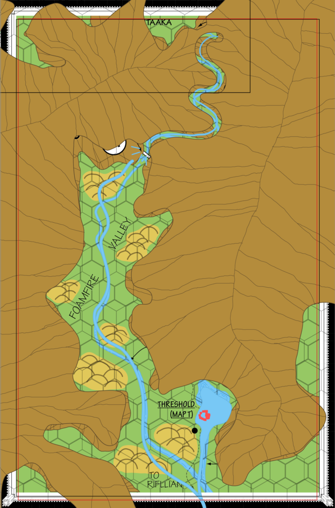
The fit shown here matches the southern mountains as well as possible, ignoring the northern part of the map entirely. Even then, the rivers are pretty different, Threshold is 2 miles or so out, and the lake is totally different.
The Lost Valley map is even worse. It doesn’t fit well with either of the other maps, and this is compounded by the loose fit I’ve chosen for the northern part of the Foamfire Valley map.
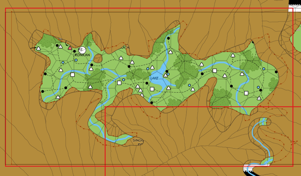
This is a best fit for the valley itself, which also happens to fit the box outlined on the 3 mile map nicely, too (the red outline in this snapshot). However, as you can see the mountain pass leading to the valley is rather offset. The best option would seem to be to merge the mountain pass at one of the overlapping points.
In conclusion, I’m going to try to preserve the detail of the 2 mile per hex maps while giving them the best placement I can find on the 3 mile per hex map, and merge them all together into a cohesive whole. I’m also adopting the vertical hex columns of Hutaaka for the Foamfire Valley, as it doesn’t make sense to mix vertical and horizontal hex columns on the same combined map. This is rather easily done, since the symbols are not really connected to the hexes in these maps.
It’s worth noting at this point also that various things referenced in earlier books can now be marked on these large scale maps:
- Caves in the nearby hills from the solo adventure. (Basic Rules Set 1983 Players Manual p. 3)
- Castle Mistamere can now be placed 3 miles north of Threshold. (Basic Rules Set 1983 Dungeon Masters Rulebook p. 4)
- The Black Woods, 5 miles west of town, have also been marked. (Expert Rules Set 1983)
You may have noticed the historical notes I’ve made from the text of B10. These may be used to plot a series of maps charting the history of the region. Although details and exact dates are largely missing, it should at least be possible to create some useful maps painted in broad strokes to illustrate the situation.
Map 45: “DM Map 5 The Elven Land” from CM7 (February 1986)
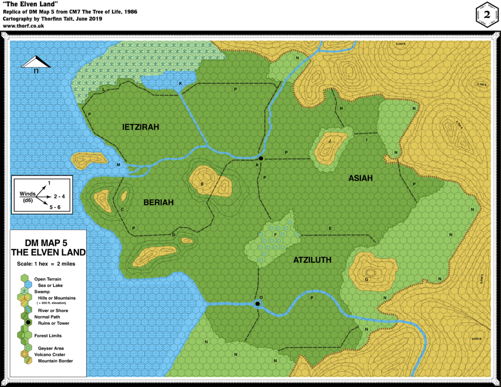
From the Atlas of Mystara:
Bruce Heard’s second foray into Mystara, and his first focusing on a Known World nation, CM7 focused on the Selinar region of Alfheim. Following the development of the Emerlas region in O2 two years before, CM7 was the second module to zoom in on Alfheim, although in fact much of the module takes place in the Sylvan Realm on the other side of the continent.
CM7’s maps are primarily notable for their use of contour lines — a first for Mystara’s geographical maps, and one that would not be repeated in most future maps.
The first entirely new area introduced in 1986 was the Elven Land in CM7 Tree of Life. Located thousands of miles away from the Known World area, this land is presented as an ancestral ground of the elves of Alfheim. The map itself is mostly devoid of labels, so most of the additions can be found in Textual Additions for CM7 below.
Additions
- Borders — Although none are marked, the edges of the forest can be taken to be the edge of the Elven Land.
- Coastline — The coast along an unnamed sea is all new here.
- Dominions — Asiah, Atziluth, Beriah, and Ietzirah appear to be either region or dominion names, although which is not clear from the map.
- Islands — An island at the estuary of the northern of the two river systems, as well as a river island (marked “O”) on the course of the southern river.
- Lakes — A lake bordering on the course of the swamp in the north.
- Mountains — In a first for Mystara’s maps, hills and mountains are illustrated with contour lines, in this case 300 ft. lines. The Elven Land appears to be surrounded by high ground, except in the southwest along the coast. A volcano crater is marked at the top of one of the mountains.
- Nations — The title suggests Elven Land to be a nation.
- Plateaus — None, but the “mountain border” is marked all along the edge of the higher ground using a plateau-like symbol — similar to how it appeared in B10.
- Rivers — Two river systems appear, in the north and the south, both unnamed. The northern system appears to bifurcate, with one strand heading northwest to the swamp, while the other continues west to a delta at the coast.
- Seas — The west is dominated by an unnamed sea.
- Settlements — Two are marked using a “Ruins or Tower” symbol.
- Terrain — Unsurprisingly the Elven Land is dominated by forest, including some hills covered with forest. There is also an interesting new element in the geyser area.
- Trails & Roads — A network of “normal paths” crisscross the forest.
Hex Art & Fonts
- Fonts — Helvetica.
- New Symbols — Contour Lines, Geyser Area (blue unfilled circle), Volcano Crater (a circle of dashed lines).
Map 46: “DM Map 1” from CM7 (February 1986)
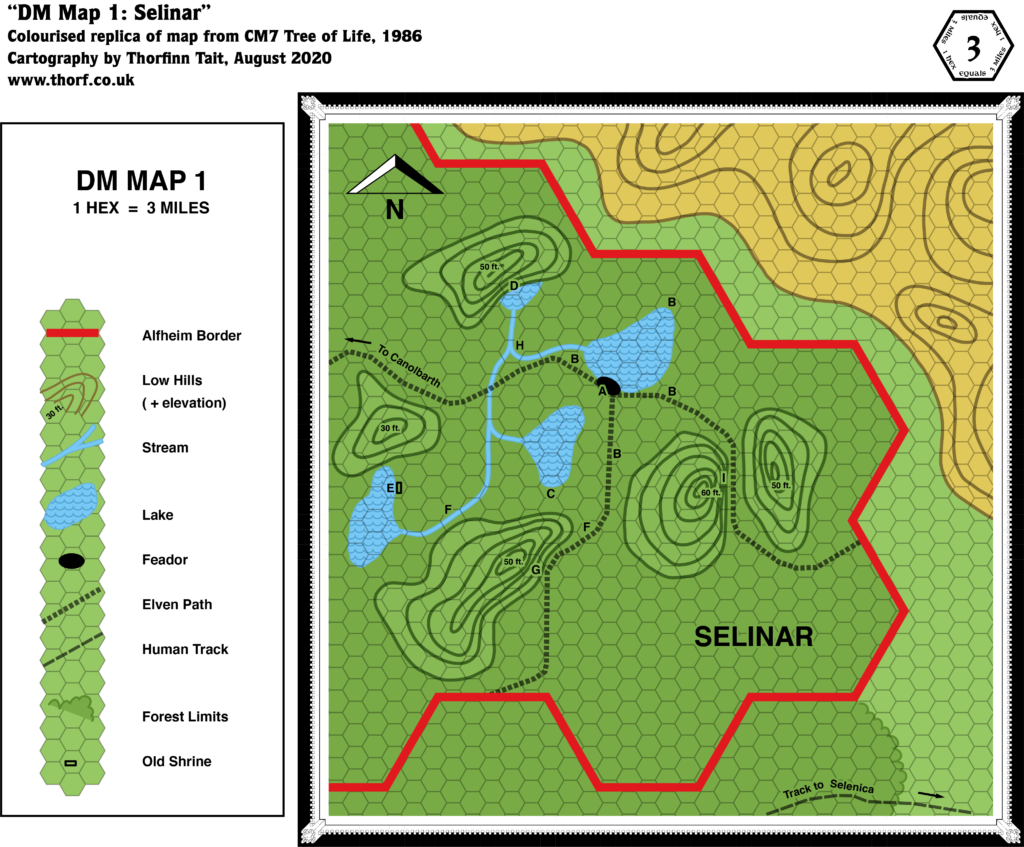
Additions
- Contours — Five hills are marked, complete with altitudes, but they are so low as to be meaningless at this scale. Some hills are also marked in the area to the northeast, across the border in Darokin.
- Lakes — The four lakes of Selinar, though they have no names at this point.
- Rivers — A small network of rivers links the lakes, although it’s not entirely clear which direction they flow in. The shape of the connections between the rivers suggest that they all flow north to the smallest lake. Where the water goes after that is also not clear, as there is no outflow. Presumably it either evaporates or goes underground.
- Settlements — Feador appears for the first time, although it’s unclear if it’s a town or a village.
- Trails & Roads — Human tracks (outside Alfheim) are distinguished from Elven paths (within). There is a network of such paths leading from south, east and west from Feador.
Revisions
- Borders — The Darokin-Rockhome border that should appear in the top right corner is not present.
- Forests — Selinar is the only major label on the map, and it appears to refer to this section of forest, in the same way that “Emerlas” was used in O2. The “to Canolbarth” label suggests that Selinar is a separate entity rather than a part of the larger Canolbarth Forest.
- Roads & Trails — The “Track to Selenica” on the bottom edge of the map is slightly further north than on previous maps. It seems likely it was included here as a reference point and a contrast to the “Elven Paths” rather than out of an intent to shift the position of the trail.
- Terrain — The high ground in the top right should include both hills and mountains. It’s not clear from the map if these are intended to follow the same scale as the key’s “Low Hills”, as their contour lines are spaced differently.
Hex Art & Fonts
- Fonts — Helvetica.
- New Symbols — Feador (black lozenge shape), likely either a town or a village; Old Shrine (unfilled rectangle).
“Players’ Map 1” from CM7 (February 1986)
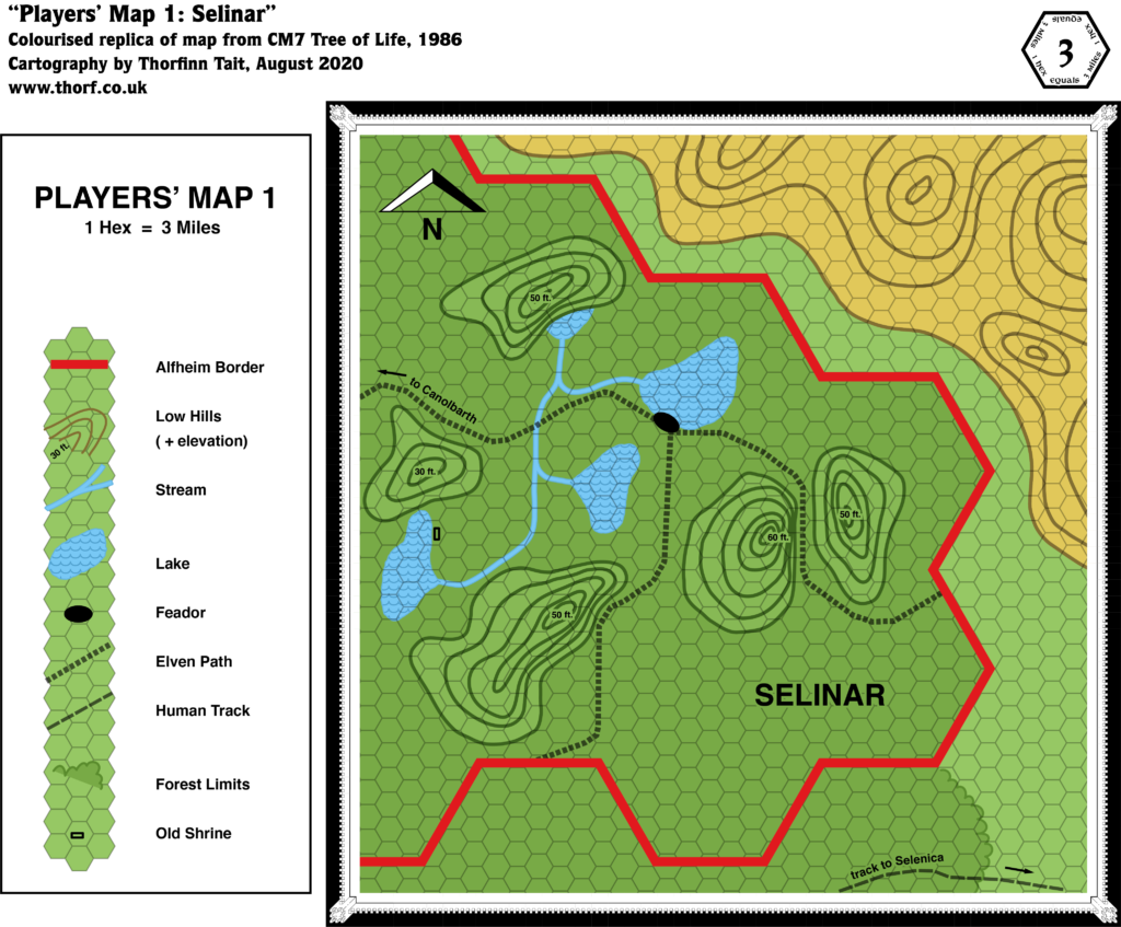
There’s nothing new here; the Players’ Map is just a clean version of the DM’s Map.
Textual Additions (CM7 1986)
- Clans — Alfheim is said to be organised into clans of elves, with the Feadiel Clan dwelling in the Selinar region of Alfheim. (Page 3)
- Dragons — Sulfar, a large red dragon that Moorkroft has sent to Selinar (pages 3-4, 6). It sits atop the hill with the Cave of the Dark Watcher. Presumably it usually resides in or near the Sylvan Realm.
- Fauna — I will split this into two parts to cover both regions.
- Selinar: Due to the nature of the adventure, most of the encounters around Selinar are not its usual inhabitants, but interlopers to harry to adventurers. As such, they are not useful to mark on the map. This includes many of the keyed encounters on the maps. Of these, the sprites at location B are locals, as is the ancient treant known as the “Old King of the Woods” at location C (page 4). The wolves, dire wolves, werewolves, and hellhounds chasing the sprites at B and also at F are interlopers (pages 4-6).
- The Sylvan Realm: random creatures likely to join the elven army, and therefore present in this region include treants, sprites, pixies, blink dogs, and unicorns. (Page 12) Other creatures are given in the keyed encounters, including manticores (location B, page 13), rocs (C, page 13), centaurs (E, page 15), griffons (F, page 15), a medusa (H, page 16), and various unique creatures and constructs (for which see the updated map).
- Features — The Old Shrine at location E turns out to be “the grave of Fillindyl Feadiel, the first elder of the … clan”. It’s just a simple altar. (Page 5) The Cave of the Dark Watcher at location G is “a cave in the southeast side of a hill, overlooking the southern elven path”. It is a circular cave with a “throne made of rough stone”, currently occupied by a beholder, the titular Dark Watcher. Though the beholder is not native to the woods, I have chosen to name the cave anyway as it’s better than just putting another nameless cave. The cave also hosts a “magical portal to the Tower of Light” in the Sylvan Realm; it’s not clear if this is a permanent feature. (Page 6) The Cave at location I, “A Nest of Spies”, is just a simple cave occupied by the agents of Moorkroft. (Page 6)
- Forests — Selinar, also referred to as “the forest of Selinar” (page 3) is located in eastern Alfheim. In the Sylvan Realm, hexes marked P denote the location of dead oaks.
- History — The story of the Sylvan Realm was detailed as follows: “Long before the oldest elf of the Feadiel tribe was born, the most ancient elven clan faced its doom. At the end of a long and bloody war, surrounded by their sylvan domain, the clan decided to hide their Tree of Life and magic-jar in mass, one elf into each great oak of the forest, hoping to outlive this dark century. Only one would remain as Keeper of the Sacred Tree, until the twilight of his life, at which time another elf would be wakened to replace the eldest.” Although the lifespan of an elf has not been explicitly fixed at this point, this presumably places the Sylvan Realm’s struggle far in the past. (The next paragraph gives a hint in that the Treekeeper only needs to wake a replacement in the time of the Mage’s great-grandson, i.e. Moorkroft IV.) The text continues: “When the black army swarmed the woods, no elf was there to be found “alive.” The Sylvan Realm was ransacked and, without knowing, many elves were destroyed.” After this, the land was occupied by the forces of Moorkroft. This continued for another three generations of Moorkrofts, so that the current Moorkroft IV is “the mage’s great-grand-son” (all page 2 up to this point) — actually his fourth incarnation. Moorkroft I, II, and III presumably had normal lifespans, so the last tree keeper returned at some point after the span of three human lifetimes. Moorkroft IV has been extending his life since then. (All page 25) One more point is worth noting here: “As for the Feadiels, refusing the passive solution of the clan, they took a small limb of the Tree of Life and fled. They established another tribe, in another land, and so became the ancestors of the party’s clan.” This clearly refers to the Feadiels of Alfheim. (Page 2)
- Lairs — The encounters in the Sylvan Realm detail a number of lairs:
- Manticore Lair — 4 manticores in a cave at the top of the hill. (Page 13)
- Roc Nest — a single large roc with 5 eggs. (Page 13)
- Griffon Lair — 16 griffons lairing on the north side of the volcano. (Page 15)
- Medusa’s House — More a little cottage than a lair, it houses a single medusa. (Page 16)
- Nations — CM7 introduced more details than ever before on the elves of Mystara:
- The Elven Land introduced in this module “may be somewhere else on the continent, the remotest area being best. If using the D&D Companion Set continental map, the area suggested is the northwest corner.” (Page 2) Thus, the Elven Land is to be placed in northwestern Brun. While the area covered by the Elven Land’s 2 mile per hex map is insignificant compared to the continental map of Brun, it seems reasonable to use it as a guide, placing the Elven Land on the northwest coast close to the latitude of Frosthaven on the other side of the continent. The name Elven Land is used on the map and in the text, but the text also uses Sylan Realm (page 2, etc.), and it is this latter name that has stuck ever since, from GAZ5 onwards. Pages 12-18 and 23-36 detail various parts of the land. It is said that “The land of the ancients is a remote realm, bordered on the north by a huge swamp-forest, on the east and southeast by a chain of high mountains, and on the west by an ocean. The south is open to vast steppes. Most of the realm is covered with forest”. (Page 12) “The forest was originally divided into four areas called Ietzirah, Beriah, Atziluth and Asiah, the four archaic terms for Water, Air, Fire, and Earth.” These names are taken from the Kabbalah’s Four Worlds, where they are indeed representative of those elements, except that Water and Air are inverted in the order listed. (Page 12, reference to Wikipedia)
- Alfheim is “a group of large clans allied under the authority of a sole king for the defense of the woodland and of their civilization.” (Page 3)
- Races — While Alfheim is predominantly elven, it is noted that “Many powerful druids live in Alfheim, helping the elves to maintain the sylvan realm.” (Page 3)
- Settlements — “The Feadiels’ clanhold is located in the forest of Selinar, on the shore of a small lake. The hold is called Feador.” It is repeatedly referred to as a village. (All page 3) In the Sylvan Realm, the remains of the original elven clanhold are located at the crossroads at location A, where “the surrounding area seems to be covered with endless ruins” overgrown with oaks and bushes. Only the Crystal Dome and its internal structure holding the Tree of Life survives. (Page 13) All of the locations marked N are “Wyvern Camps”, which are the camps of Moorkroft’s black hordes. There are eleven such camps, each of which is garrisoned with 100 orcs, 12 wyvern riders with their 12 mounts, 12 hellhounds, and a fire giant commander. (Page 18)
- Terrain — The Selinar region of Alfheim: “Selinar is that portion of forest northwest of Selenica, above the Grand Duchy of Karameikos.” (Page 2) It sounds like Selinar is the name of the forest here, which gels with the “to Canolbarth” labels on the maps. This is also in accordance with O2’s Emerlas region, which also seemed to be portrayed as a separately named forest region rather than a region within the overall Canolbarth Forest. On the other hand, the implication from small scale maps has always been that Canolbarth is the name of the forest as a whole, likely even including the areas outside Alfheim’s borders (because after all the borders are just a political line on the map).
- Trails & Roads — The difference between the Elven Paths and the Human Tracks noted on the map is defined in the text: “There are there paths leaving the hold: east, west and south. Visible only to elves and druids, they are considered a military secret.” (Page 3)
- Waterfalls — Location D on the map is the Waterfall of Rainbows (pages 4-5). It “gushes out at the top of a cliff to rush down to a small lake at the bottom of the hill.” The source may well be magical, because the hilltop is surely not expansive enough to generate a roaring waterfall just from runoff.
Analysis
The Selinar map adds some nice details within Alfheim, though its features outside of Alfheim’s borders don’t closely follow previous maps of the area. As there is little detail in these latter areas, they are best ignored.
The precise location of the Sylvan Realm is up in the air at this point; although its general location in Northwestern Brun is fixed, the coast doesn’t neatly fit into any one spot on the continental map. Wherever it goes, some adaptation will be necessary. One option would be to apply a rotation of some sort. For example, a 30º rotation to the right would make its coast line up with the continental map far more easily, while also changing its hex grid from horizontal to vertical columns. On the other hand, this would mess with directions referenced in the adventure, so perhaps it would be better to use it without a rotation.
In any case, since there is no way to conclusively work this out at this point, I will leave it vague for Mystara 1986.
Map 47: “Map V: Norwold” from M2 (May 1986)
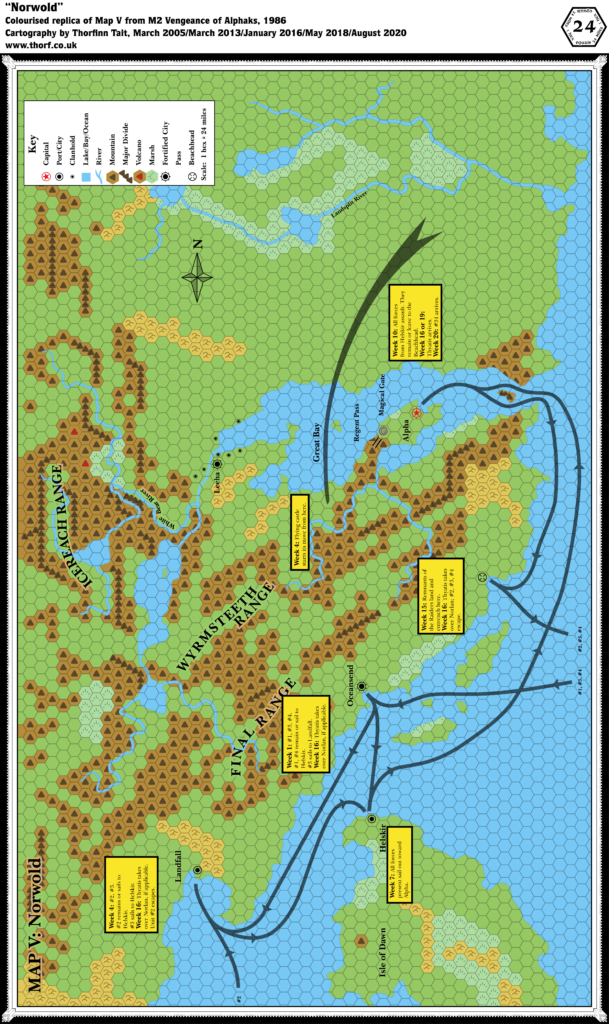
From the Atlas of Mystara:
As with the module itself, M2’s maps of Norwold were very much “more of the same”. In fact, they duplicated CM1’s original map to such an extent that the Atlas originally only included them as a combined map. The one thing of note with this map is that it was the first to include any settlements on the Isle of Dawn, with the introduction of the port town of Helskir.
Additions
- Features — The Beachhead and the Magical Gate are both new, though presumably temporary locations just for M2’s adventure.
- Mountain Passes — Regent Pass is marked on the map for the first time; previously it was only referenced in CM1’s text.
- Settlements — Helskir appears for the first time on this map.
Revisions
- Settlements — Oceansend, Alpha, and Leeha are shown to be fortified.
- Terrain — The island at the mouth of the Great Bay has gained mountain symbols.
Hex Art & Fonts
- Fonts — Baskerville.
- New Symbols — Fortified City (a combination of the Capital and City symbols with the spiked circle from the Module Location/Point of Interest symbol), Magical Gate (a whirlpool-like swirl), Beachhead (a circle with lines pointing to its centre, like the sights of a gun).
“Map I Players’ Map: Norwold” from M2 (May 1986)
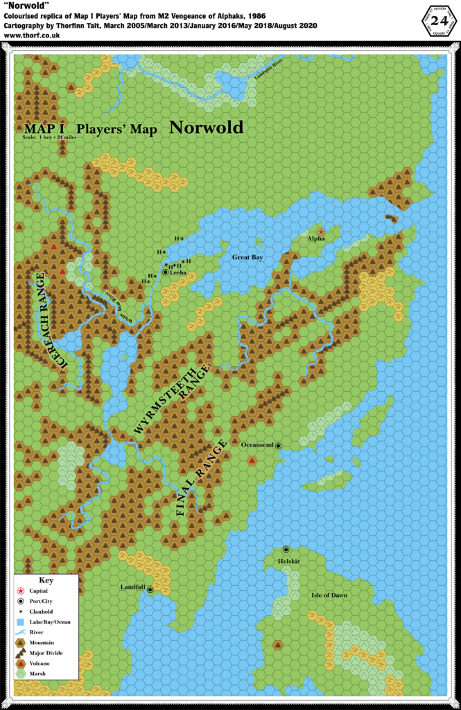
Nothing new to see here. Moving right along…
Textual Additions (M2 1986)
- Barbarians — Barbarians of the Red Banner are located “anywhere north of the Great Bay” (page 23).
- Heraldry — The blue star pennants are the symbol of Baron Norlan of Qeodhar (page 5).
- Military — Pages 22 and 23 include extensive army and navy rosters for not just Norwold but also a whole host of other nations.
- Races — The military rosters (pages 22-23) suggest the races inhabiting various nations and regions: Thonia’s army includes horsemen and pegataurs; Western Minaea’s is a pirate fleet; the Alphatian armies seem to be exclusively human; Minrothad’s sailors are all human; Norwold’s armies are mostly humans and elves, with halflings from Leeha and dwarves from Stormhaven.
- Regions — The military rosters (pages 22-23) reference two regions previously featured on the Master Set world map: Lands of Thonia and Western Minaea.
- Rulers — Lernal the Swill is noted as “governor” or Landfall (page 21). Previously CM1 had listed him as “lord”, though neither of these titles was capitalised. The military rosters include numerous leaders, some of whom may be rulers: Krondell the One-Eyed, a pirate of Western Minaea; Sire Rodnox, leader of the Regent Pass Fortress and its garrison; and others. (Pages 22-23) Prerolled characters include two new dominion rulers, Bardeen Longwalker from Ostland and Winnefred of the Lake, who “spent her early years adventuring in the Ethengar Khanate”. Other PCs are Trent the White from Heldann, Adik de Chevas, Lucci Dhay from Karameikos, and Delsel Oaktree. (All page 32)
- Settlements — The text refers to a few settlements, some on the map, others not:
- Dawn Rising is a small fortified town to be placed in a PC’s or friendly NPC’s dominion. It has a town map (Map I, page 15), but otherwise no fixed location. We can add this to the already rather extensive list of things without a set location in Norwold. Note that the town name is derived from the section and map heading, “Storm at Dawn Rising”. It’s a little ambiguous whether or not this was intended as the town name. (Page 6)
- Similarly, Coiger de Mory’s lair “is housed in one of a series of forested bluffs overlooking a small river. The area is remote, far from any human, demi-human, or humanoid communities” (page 8 and Map II, page 16). This is another unplaced location.
- Helskir is barely mentioned, appearing only as a rallying and resupplying point for Baron Norlan and the Thyatian forces (page 21). The army lists don’t even list it by name, instead only saying “Isle of Dawn” (page 23).
Special thanks to Michele Carpita for contributions to this list.
Analysis
M2’s map is very much geared towards the adventure. As a result, though it appears that it’s full of new details, in fact there is little to add to CM1’s Norwold. The Beachhead is a prime example of this, as it sits in a spot that is surely a prime location for a city, and yet represents just a temporary tactical position. So too with the Magical Gate.
On the other hand, the new Fortified City symbols are great, but they also present us with a fascinating dilemma: this symbol only appears here, never to be reprised in future maps. It is a nice little addition, giving extra information about settlements in a very concise and intuitive way. Should we therefore adopt it in all maps moving forward? Doing so would undoubtedly be difficult, as we are lacking this information for the majority of marked cities on the map. Moreover, if the symbol is used at all, its absence then implies no fortifications.
The best solution for this seems to be to adopt it only on the separate Norwold map, leaving it off the combined Brun map.
Finally, as with previous Norwold modules, there’s quite a bit here that could be placed on the map, such as the dominions of the prerolled characters. See CM1’s Norwold map for those details. For now, as there is no way to conclusively place these details on the map, we will just note them for future reference.
Map 48: “The Multiverse” from Immortals Set (June 1986)
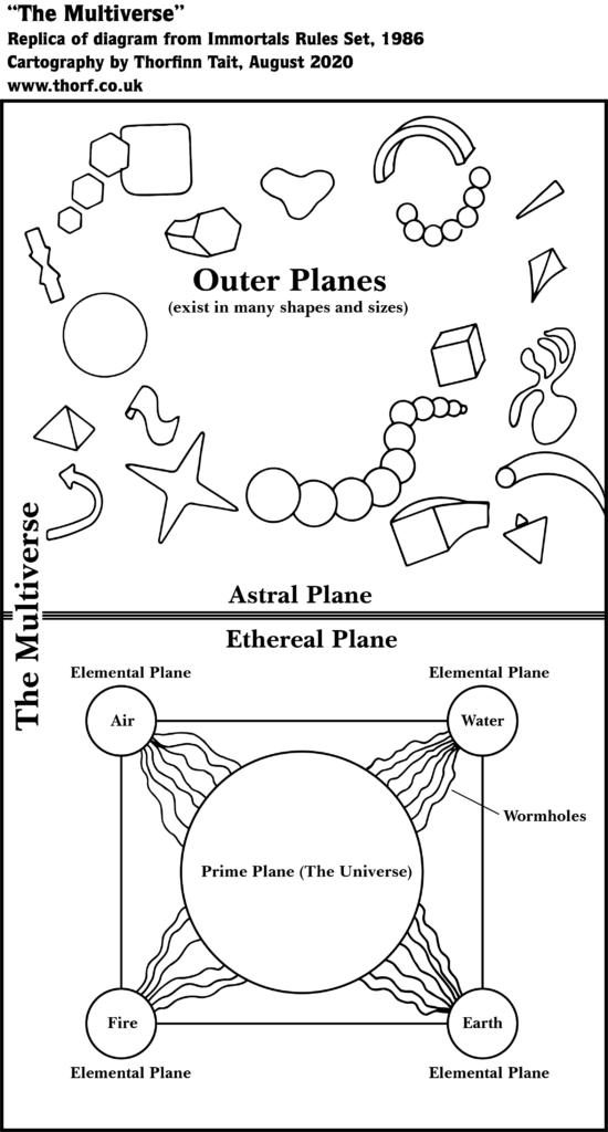
From the Atlas of Mystara:
The Immortals Set provided the first — and perhaps only — visualisation of Mystara’s cosmology. Drawing on the elemental opposition diagram from the Companion Set, it presented a reasonably clear view of the setup of the planes. This was sorely needed, because the textual description in the DM’s Guide to the Immortals was rather heavy reading.
Additions
- Planes — The Multiverse consisting of two main sections, the Astral Plane encompassing all of the Outer Planes, and the Ethereal Plane encompassing all of the inner planes: the Prime Plane and the four Elemental Planes of Air, Water, Fire, and Earth. Also Wormholes connecting the Elemental Planes to the Prime.
Revisions
- Elemental Planes — The order of the Elemental Planes is different from that presented in the dominance and opposition diagram in the Companion Set. Fire and Earth have been switched.
Hex Art & Fonts
- Fonts — Baskerville.
- New Symbols — It’s all abstract representations.
Textual Additions (Immortals Set 1986)
Most of the text is far beyond the scope of this project, interesting though it is. Highlights include the concept that Mystara is the ancient world, in the Age of Magic; a detailed overview of the solar system, making it close but not quite identical to the real world’s configuration; and a rundown of the closest stars.
Just for fun, I have whipped up a diagram presenting the solar system in visual form.

Make of it what you will. The diagram operates on two separate scales, with the planets sized to scale with each other, but the distances between them on an entirely different, far smaller scale. Moreover, the planets are spaced measuring from nearest face to nearest face rather than from core to core; otherwise, the inner planets would appear inside the sun.
I don’t want to spend a long time on this, so let’s move on.
Map 49: “Map VII Continental Overview of Wendar and Denagoth” from X11 (August 1986)
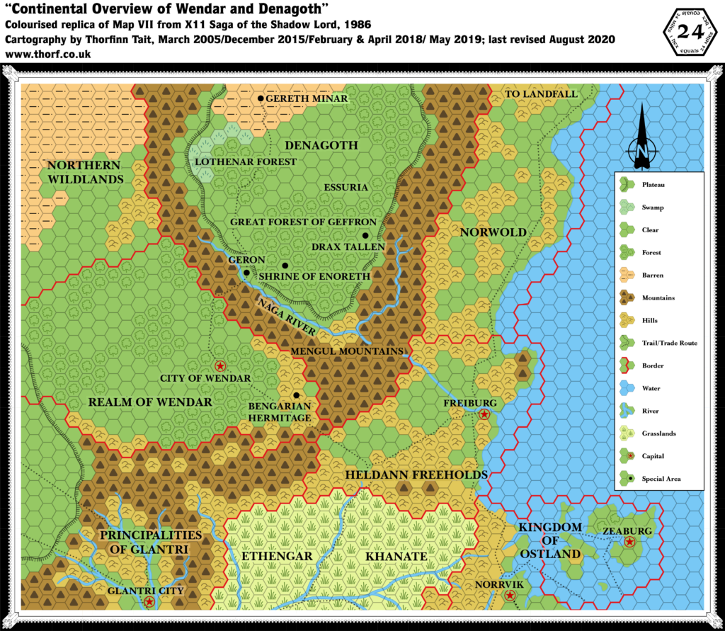
From the Atlas of Mystara:
X11 introduced two new nations on the borders of the Known World: Wendar and Denagoth. It also provided a first cursory look at Heldann, which was always rather neglected. However, the Norwold portion of the map is extremely problematic. To make matters worse, CM1’s Norwold had already provided a different view of this region, albeit without Heldann. These issues came to be known as the Norwold conundrum — an infamous problem area among Mystara’s cartographers.
Additions
- Borders — All of Wendar’s borders; northern borders for Glantri and Heldann, building on their southern edges as shown on previous maps; borders for Denagoth and southern Norwold.
- Mountains — The Mengul Mountains surrounding the Denagothian plateau.
- Mountain Passes — Although marked by trails rather than a special symbol, there is seemingly a pass leading up onto the plateau from Geron, and another between Heldann and Wendar.
- Nations — Wendar and Denagoth.
- Plateaus — The Denagothian plateau. It is unnamed on this map.
- Rivers — The Naga River. The river has a break as it passes through the Mengul Mountains towards Freiburg and the sea; it’s not entirely clear if this is by design, or simply to avoid obscuring the label for the mountains. Either way, it seems unquestionably the same river.
- Settlements — The City of Wendar and Freiburg, capitals of their respective nations. All other icons on the map are marked “Special Area”: Bengarian Hermitage in Wendar; Geron, Shrine of Enoreth, Drax Tallen, and Gereth Minar in Denagoth.
- Terrain — Most of Wendar, all of Denagoth, and the Northern Wildlands are all new. Denagoth includes the Great Forest of Geffron, the Lothenar Forest, and Essuria. It’s not entirely clear what the last of these represents, but the size of the font suggests it’s subordinate to Denagoth.
- Trails & Roads — The trails leading north from Ethengar and Norrvik (from Expert 1983) have been extended. From Ethengar, the trail leads north into Heldann before splitting, with the eastern trail leading to Freiburg, while the western trail leads first into Wendar, then through its capital, before turning northwards to Geron and on up onto the Denagothian plateau, where it skirts the forest of Geffron, goes through Lothenar, and finally terminates at Gereth Minar. The Norrvik trail leads straight to Freiburg, meeting the Ethengar-Freiburg trail just west of the city. Finally, a new trail follows the coast north of Freiburg all the way to the edge of the map, ostensibly leading to Landfall.
Revisions
- Borders — Although the borders for Heldann and Norwold are shown here for the first time as red lined borders, in fact CM1 included an area definition of Norwold’s border, and the Heldann-Norwold border given here contradicts that. Specifically, where X11 has the border extending from the mountainous peninsula inland to the “Mengul Mountains” label, CM1 had it at a 45º angle to this, from the peninsula to the border near Drax Tallen.
- Coastline — The entire coastline north of Freiburg is completely different. See Errors below.
- Errors — Two rather egregious errors beset this map.
- There is an error in transcription, with a column of hexes missed out in Ethengar, pulling eastern Ethengar and the Northern Reaches out of sync. The missing column is the one directly south of the hex between Heldann’s twin mountains. Revisions due to this error have not been included in this list.
- Norwold as depicted on this map is completely at odds with all previous maps of the area. Landfall should appear on this map, approximately four hexes south of the “OL” of “Norwold”.
- Terrain — See “Errors”.
Hex Art & Fonts
- Fonts — Baskerville.
- Revised Symbols — Swamp (grass strokes with a line underneath; in other maps, including other X11 maps, swamps are represented by a semicircular arrangement of five short grass strokes).
“Map XII Players’ Map of Wendar and Denagoth” from X11 (August 1986)
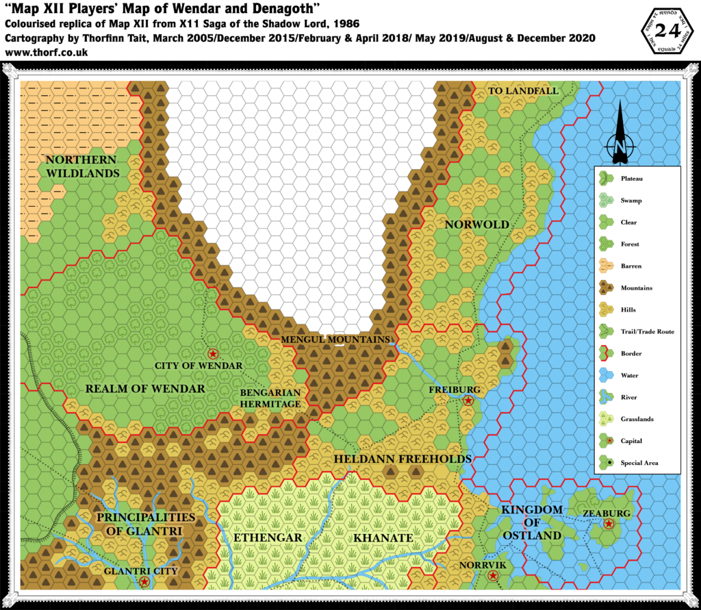
Nothing new to see here — it’s a simple redo of the DM’s map with Denagoth whited out. Moving swiftly on…
Map 50: “Map VI Trail to Denagoth” from X11 (August 1986)
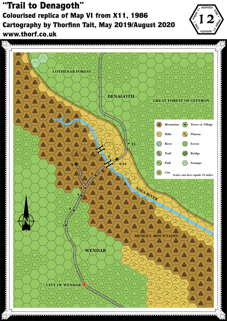
From the Atlas of Mystara:
Wendar and Denagoth, situated as they are on the borders of the Known World, were always rather neglected in Mystara’s maps. Their primary source was 1986’s X11, but it only provided a bare-bones outline of the territories, with a surprising amount of inherent ambiguity as well as mapping inconsistencies.
This map is no exception: while it appears to provide a few more details than the smaller scale 24 mile per hex map, in fact the two maps are largely incompatible. Key to this is the plateau itself, which a quick comparison reveals to be rather different between the two maps.
Additions
- Settlements — An unnamed Tower or Village at 6.
- Trails & Roads — The roundabout trail through the mountains providing an alternate route across the Naga is new here.
Revisions
- Plateau — The line of the plateau is quite radically different from that in the 24 mile per hex map.
- Rivers — The Naga River has gained a short tributary near its source.
- Terrain — Along with the different plateau, the terrain is somewhat different from the 24 mile per hex map, especially in the top left corner where the plateaus are completely out of sync.
Hex Art & Fonts
- Fonts — Baskerville.
- New Symbols — Bridge (two parallel lines with serifs extending outwards at each end), and a strange plus or X in a circle that is undefined in the legend.
Map 51: “Map V Lothenar Forest” from X11 (August 1986)
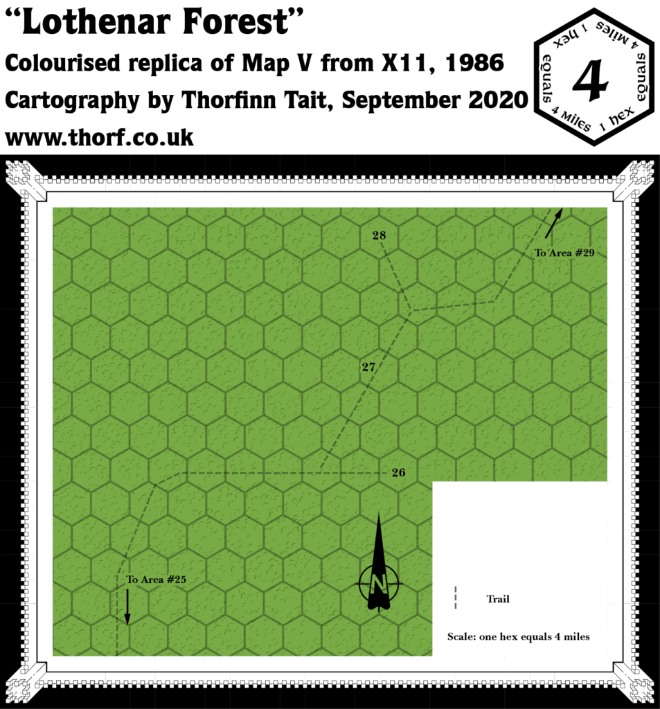
From the Atlas of Mystara:
This has to be the most lacklustre “map” in the whole publication history of Mystara. What else is there to say, really?
Additions
- Terrain — The Lothenar Forest is forest. (Wait, is this an addition?!)
- Trails & Roads — A simple trail leads through the forest.
Hex Art & Fonts
- Fonts — Baskerville.
- New Symbols — None. The legend looks positively lonely in its stark emptiness.
Map 52: “Map X The Great Forest of Geffron” from X11 (August 1986)
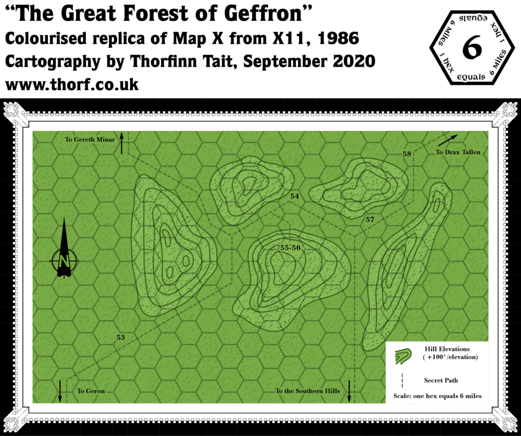
From the Atlas of Mystara:
While not the worst map from X11, Geffron is pretty lacking when it comes to detail. Bonus points for the contour lines, though. It’s also easy to place this together with the 24 mile per hex map, thanks to the Shrine of Enoreth appearing on both (it’s tag 56 on this one).
Additions
- Terrain — There are forested hills in the Great Forest of Geffron.
- Trails & Roads — A small network of trails leads through the forest near the Shrine of Enoreth (55-56 on the map). The western trail appears at first glance to be a continuation of the trail north from Geron, eventually leading to Gereth Minar. However, the Shrine is in fact due east of Geron, so this seems unlikely. More likely, this is a separate trail. But see Analysis below.
Hex Art & Fonts
- Fonts — Baskerville.
Textual Additions (X11 1986)
- Government — Wendar is a monarchy ruled by a Wizard-King. (X11 p2)
- Heraldry — A red wyvern is the symbol of the Shadow Lord. (X11 p5)
- History — Wendar has known peace and prosperity “for decades” under its benevolent ruler and “the protection of the might Empire of Thyatis”. The peace is also thanks to the Elvenstar, an artifact protecting the lands. (X11 p2) Lord Gylharen used the Elvenstar thirty years ago to foil an invasion by Landryn Teriak, but a year ago Teriak succeeded in stealing the artifact via one of his minions. Now Wendar is vulnerable and suffering from bad luck. (X11 p3)
- Lairs —
- Leaders — Wizard-King Gylharen, also titled Lord Gylharen, is the leader of Wendar. (X11 p2-3) Bensarian of Kevar, the Sage of Wendar, is another important figure, living in a hermitage in the Kevar Hills. (X11 p3) Landryn Teriak, also known as the Shadow Lord, is an evil necromancer and the tyrant of Denagoth. (X11 p3-4)
- Mountain Passes — Between Wendar and Heldann there is a mountain pass through the southern Mengul Mountains. “A small garrison is permanently located at the pass”. (X11 p2) Another pass connects Wendar to Denagoth: “Only a narrow path links Wendar to Denagoth, and only heavily armed troops would dare to cross it and brave the monsters lurking there.” (X11 p3) “Wendar maintains small patrols of border guards” including at the pass to Denagoth. (X11 p4)
- Mountains — The Mengul Mountains: “To the south and east, the towering Mengul Mountains reach 10,000 feet, forming an impassable barrier. … Although the mountains around the plateau are within Denagoth’s boundaries on Map VII, they are mainly unclaimed and uncivilized areas infested with ruthless humanoids and monsters.” (X11 p3)
- Nations — Wendar is the nation directly north of Glantri. Denagoth, Land of the Shadow Lord, is northeast of Wendar, occupying a formidable plateau and its surrounding mountains. (X11 p2-3)
- Plateau — “Denagoth is located on a high plateau, at an altitude of about 6,000 feet above the valley of Wendar.” (X11 p3) “The terrain just north of the Naga River is the southernmost edge of Denagoth, rising gradually to the plateau. Clumps of pine trees grow on the slope. Half way up is Geron, a small village.” (X11 p9) Also, “All along the plateau side grow numerous small forest groves”. (X11 p10)
- Races — Wendar is primarily inhabited by elves and humans: “The large forests and plains covering the rich valley are the common dwellings of elves and human farmers that make up the Wendarian population.” (X11 p2) Denagoth’s population of humans, orcs, gnolls, goblins and “various other dark folk” is “unevenly distributed throughout a few settlements, sundry farms and other habitats”. (X11 p3) There are orcs northwest of Azor’s Castle in the Mengul Mountains. (X11 p7)
- Regions — The Northern Wildlands are referred to as “vast barren lands… which extend for hundreds of miles to the north and west. This vast expanse of rocks and dry plains is sparsely inhabited and lawless.” (X11 p2)
- Rivers — “The Naga River that flows southeast is totally unnavigable until it reaches the Heldann plains, due to the numerous cataracts and turbulent waters.” (X11 p3) The Naga River can be crossed only at one of the bridges. “Near Geron, the Naga is in full flow; the powerful current prevents any attempts to swim across to the other side.” (X11 p9)
- Settlements — The text implies more settlements than are shown on the module’s maps.
- The City of Wendar is the nation’s capital, and indeed the only settlement marked within its borders on the maps. During the last year it has suffered a plague, “killing thousands”; “one-seventh of the population perished”. (X11 p2) However, p4 has Gylharen state that the plague killed “hundreds”. This can be reconciled if it is considered that the first reference includes the whole country, while the second only includes the city itself.
- Wendar’s population is said to inhabit the plains and forests. It is implied that there may be small settlements scattered throughout the nation. (X11 p2)
- Azor’s Castle is the home of a cloud giant in the Mengul Mountains near the pass to Denagoth. He lives with his pet dire wolves. (X11 p6-9) Thirty years ago this was a Wendarian outpost. (X11 p9)
- Geron is “a small village across the border”, that is in Denagoth. (X11 p4) It is populated by craftsmen, peasants, merchants, etc., of varying alignments.” (X11 p10)
- Denagoth is said to have “a few settlements, sundry farms and other habitats”. (X11 p3) Some are marked on the map, but the implication is surely that there may be others.
- The Army of Denagoth Bivouac is a temporary camp located near the edge of the plateau approximately 24 miles north from Geron along the trail. The text says it is “to the northwest of the roadway, about 700 yards away”. (X11 p18) The camp is currently home to around 4,980 troops: 1,200 mixed bands of orcs, 1,000 Evil Eye Tribe orcs, 800 Bloody Head orcs, 700 Black Axe hobgoblins, 700 Wolf Claw Tribe goblins, 500 human bowmen (Archers of the Lord), and 80 human Dark Lancers. (X11 p19 map & text)
- Terrain —
- Wendar is “a large valley wedged between the Mengul Mountains, the Principalities of Glantri, and the vast northern wildlands. The large forests and plains covering the rich valley are the common dwellings of elves and human farmers that make up the Wendarian population.” (X11 p2)
- The Kevar Hills lie at the eastern edge of Wendar. (X11 p2) The sage Bensarian makes his home in these hills. (X11 p3)
- Denagoth is “a bleak realm to the north of Wendar beyond an awesome barrier known as the Mengul Mountains. The mountains are feared almost as much as the undefined and dark lands beyond them.” (X11 p3) “The central portion of the country runs out into a large grassland area known as the Plains of Avien. The barren lands to the north are thought to be beyond the knowing of man alive. Within the Denagothian plateau itself there are grasslands, swamps, forests and marginally arable land. Unevenly distributed throughout a few settlements, sundry farms and other habitats, the population is comprised of humans, orcs, gnolls, goblins, and various other dark folk. The orcish hordes (dominant in the army) have been culled from their camps in the Mengul Mountains.”
- Lothenar Forest, aka the Forest of Lothenar is “a very dense forest with monstrous overarching trees shrouding the roadway. It was once populated by elves at a time when Landryn Teriak was not dominant in Denagoth. The forest was a peaceful home to treants, sprites and elves alike. … a black dragon came and cleared the elven folk from their strongholds in the wood. Denolas and his vassals perished before the acid attacks of the beast.” (X11 p20)
- Trails — The City of Wendar “marks the end of a long caravan route from the open city of Freiburg, in the Heldann Freeholds, and the Ethengar Khanate. The trade route crosses the eastern forest of Wendar and the Kevar Hills before reaching the mountain pass to the Heldann Freeholds. Wendarian soldiers often patrol the trade route between the capital and the frontier, for it is vital to the realm’s survival.” (X11 p2) Another trail leads north: “The narrow trail beyond the citadel of Wendar is but a narrow unfrequented path leading to the dark lands of Denagoth. It has been unused for nearly thirty years.” (X11 p2)
Analysis
X11’s four maps are riddled with problems, both with each other as well as with previous maps.
The 24 mile per hex map has two rather major errors, as noted above in “Revisions” for that map. The first — hex misalignment of the Ethengar/Vestland area, is easily fixed by ignoring X11 and overwriting it with X1. The second — the infamous Norwold conundrum — is a little harder. I have taken the simplest available option to fix this, using X11 for Denagoth and Heldann, but CM1 for Norwold. The meeting point is the western inlet of the bay north of Freiburg.
Further, due to CM1’s rotation, that part of Norwold had to be redone to match the hex grid of the rest of the Known World area. This inevitably leads to slightly different views of the terrain, but in the long run it can be solved by developing larger scale maps of the region — with CM1’s rotated map as a base, of course.
The 12 mile per hex Trail to Denagoth map at first appears to be less problematic, but unfortunately this is not the case. Overlaying it with the 24 mile per hex map reveals a rather surprising level of difference, including the line of the plateau itself.
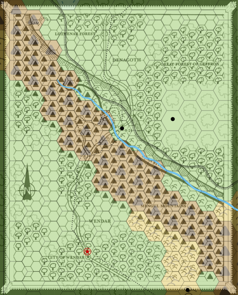
I ended up with a placement lining up the City of Wendar and Geron, which isn’t too bad. Then I adopted the plateau from the 24 mile per hex map, which to be frank has a more interesting shape anyway. After that, I altered the terrain to more closely match the 24 mile per hex map, while leaving in some details from the 12 mile per hex map — though there were scant few of these, really.
The end result now fits perfectly with its companion. I brought in all the extras from the smaller scale map that I could see, which was mainly just the border and the Shrine of Enoreth; it was hidden behind the key on the original map.
The two remaining maps are rather featureless, but nevertheless pose their own problems.
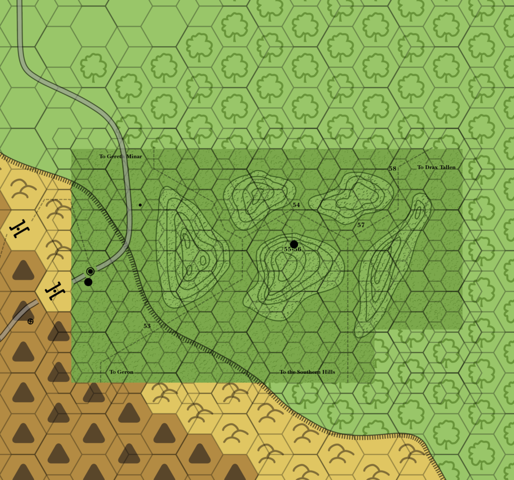
Here’s the Great Forest of Geffron map overlaid on the Trail to Denagoth. I chose to line it up based on the 55-56 location and the black dot, which both refer to the Shrine of Enoreth. Seems like the best reference point, doesn’t it?
Unfortunately, as you can see, it’s nonsense. The trail clearly doesn’t lead to Geron at all. Even with a different placement, for example ignoring the Shrine’s location and trying to line up the trail, the hill west of the trail will never fit on the plateau.
Considering that this is a map I have made fun of for being so frugal as to be practically blank, I find it highly amusing that in fact it should probably have the edge of the plateau in one corner. It even includes the village of Geron!
Here’s how things look if this is turned into an updated map:
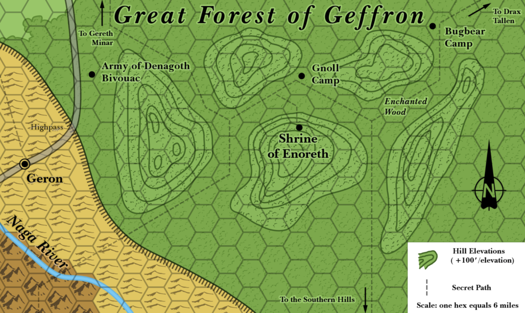
The bottom left corner of the map is not forest at all, but in fact the edge of the plateau. This combined with the sheer size of those hill contours (they’re massive!) makes me wonder if perhaps they mislabelled the scale…?
The next problem of course is the trail, which is supposed to lead from Geron (the dashed line starting in the bottom left). I can’t really see any way to reconcile this at all. The best solution would seem to be to link this map’s trail to the road north of the hill on the left, and delete the southwestern branch entirely.
Alternatively, the southwestern branch could be left as is — an alternate route up onto the plateau — and just connect it to Geron before it reaches the Naga River. This isn’t exactly how the module is written, though.
When I posted this map on Patreon, Jonathan Stromberg agreed that the scale seemed wrong. Following Jonathan’s very useful feedback, I went back to the drawing board and redeveloped it as a 4 mile per hex map.
I also decided to expand the western edge to include Geron and the plateau’s edge, mostly to resolve the otherwise misleading “To Geron” label pointing to the southern edge of the map.
The result is still somewhat problematic, but far less so than the straight 6 mile per hex map. The dire wolves encounter, which is supposed to take place some hours after entering the forest, now makes a bit more sense. And the trail from the southwest has explicitly become a separate way up onto the plateau from Geron’s path, although this could also be “fixed” by linking the trail back to Geron — either on or under the plateau’s edge.
For now, the 4 mile per hex version is the official Atlas map.
Finally, we have the Lothenar Forest “map”. How to make Mystara’s most boring, featureless map a more interesting piece?
Well, I overlaid it on the 24 mile per hex map using the trail as a guide, with the turn-off points to the two features on the map as the most important points to line up. It actually fit remarkably well. Great! Next I added in icons and labels for the two features. Oh, and a label for the forest itself. Finally, I fixed the forest borders where plains should be peeping through just a tad. I even removed the blank square from the bottom right corner so that I could feature more forest edge.
Did it work? Is it actually an interesting map now?
…
…
…
Nope, it’s a lost cause. Oh well, at least it’s consistent now.
The Maps So Far (1981-1986)
Head on over to the Atlas of Mystara web site, where the 1986 maps have a permanent home. You can read an overview of the year and see a gallery of all the updated chronological maps.
