Let’s Map Mystara 1981-1982
In which we proceed through the rest of 1981’s maps and add 1982’s sole contribution.
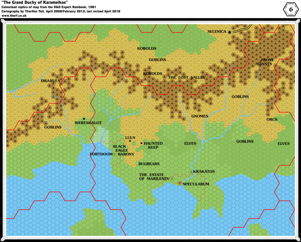
Map 4: “Grand Duchy of Karameikos” from Expert Rulebook (1981)
From the Atlas of Mystara:
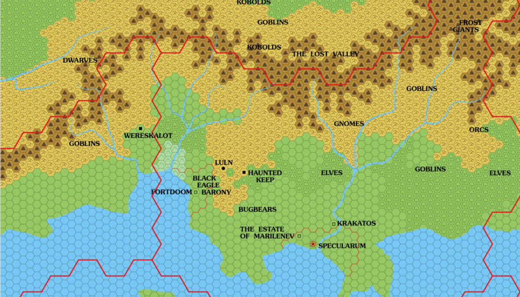
Although the 1981 Expert Set did not reprint the Known World map in any form, it did include a 6 mile per hex map of the Karameikos region. In addition to X1 (1981)’s cities of Specularum and Selenica, this larger scale map introduced a number of new settlements to Karameikos, including Luln (marked as a town); the Haunted Keep and Wereskalot in the neighbouring Five Shires (both ruins); and Fortdoom, Krakatos, and the Estate of Marilenev (all castles). The Black Eagle Barony is named, and labels appear for gnomes, elves, dwarves, kobolds, goblins, orcs, bugbears, and frost giants.
Interestingly, the Lost Valley is shown (though hard to make out) and labelled — and it’s across the border, in Darokin.
The text on page X60 provides some level of detail for some of these names, as well as a few more labels to add to the map: Gulf of Halag and Black Peaks/Cruth Mountains/The Steach.
The text also sets up the Black Eagle Barony and defines its relationship with Luln, and notes that the Haunted Keep is also known as Koriszegy Keep. Amusingly, half of the page is given over to the gnomes, although there is no mention yet of the name of their settlement.
Additions
- Dominions — the Black Eagle Barony and the Specularum area (unnamed).
- Fauna — numerous labels across the map, mostly demihumans and humanoids: dwarves, elves (in two places), gnomes; bugbears, frost giants, goblins (in four places), kobolds (in two places), and orcs. Interestingly, all of these labels correspond to cave icons, except for the elves and one goblin label — all of which occur in forests. These caves are therefore the settlements of these peoples.
- Settlements — Luln (a village); Fortdoom, Krakatos, and the Estate of Marilenev (all castles); Haunted Keep and Wereskalot (both ruins).
- Terrain — the Lost Valley is located just across the northern Karameikos border, inside Darokin.
Revisions
- Coastline — while it broadly matches X1 (1981)’s coastline, there is some added detail, as is expected for a larger scale map.
- Rivers — very similar to X1’s rivers.
- Settlements — Specularum and Selenica have both moved just slightly from their X1 positions.
- Terrain — generally in line with X1’s 24 mile per hex map, albeit finely detailed to match the conversion to a larger scale. The mountains look a little emaciated compared to the smaller scale map, but it’s easy to see their shape as a consequence.
Hex Art & Fonts
- Fonts — Souvenir.
- New Symbols — Castle (empty square).
Textual Additions (Expert Rulebook 1981)
- Climate — “The weather throughout the area represented on this map is generally temperate and mild with short winters of little or no snowfall and long summers. Rainfall is ample but not heavy and easterly winds blow cool breezes from over the sea.” (p. X60)
- Government — the Black Eagle Barony is noted as a fiefdom granted by the duke. The government within the barony sounds like a dictatorship. (p. X60) The gnomish government sounds like a democracy. (p. X60)
- Military — Specularum’s military is noted at 500, with an army of 5,000 raisable in times of war, and a “small fleet of warships”. The Black Eagle Barony has “a garrison of 200 troops”. (p. X60)
- Mountains — “The mountain range running along the north edge of the map is known by different names by the peoples of the territory including the Black Peaks, the Cruth Mountains, or The Steach.” (p. X60) X1 marked the mountains of the Five Shires as the Cruth Mountains; the Expert Rulebook is thus providing alternate names for the same range, which likely continues until it meets the Altan Tepes, southeast of Selenica. (p. X60)
- Rulers — X1 (1981)’s Duke Stephan has changed to “Duke Stefan”. He has also gained a regnal number: “Duke Stefan Karameikos the Third”. Baron Ludwig “Black Eagle” von Hendriks is introduced. (p. X60)
- Scale — page X60 gives the scale of the map as 6 miles per hex.
- Seas — the bay on which the Black Eagle Barony sits is known as the Gulf of Halag. (p. X60)
- Settlements — Specularum, population “approximately 5,000”, is twice referred to as a port, and its harbour is mentioned three times in the short descriptions. (p. X60) The map shows the icon slightly away from the river and the coast, but this is likely for clarity on the black and white map. Fort Doom (as opposed to the map’s Fortdoom) is noted as “the central town” of the Black Eagle Barony, as well as “a forbidding structure”. (p. X60) The map marks this as a castle; it seems likely that this is a castle town. Luln’s population is stated to be “approximately 500”. (p. X60) The Haunted Keep is also called Koriszegy Keep. (p. X60) The gnomes in the hills total 620. This is likely divided into lairs of roughly 250, 100, 90, 90, and 90. (p. X60)
While we’re tackling the Expert Rulebook, here’s a little extra:
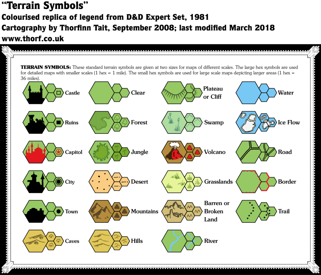
“Terrain Symbols” from Expert Rulebook (1981)
From the Atlas of Mystara:
It would be another six years until GAZ1 revolutionised Mystaran cartography with its full colour poster map filled with detailed hex art. And yet, the original Expert Rulebook (1981) presented many of those iconic hexes right at the world’s inception. They appeared in black and white, of course, and none of them would be used until 1987, but the designs were already in place, and even published.
The text on this legend perpetuates an unfortunate but very common misconception regarding scale by getting “large” and “small” scales the wrong way round. 1 mile per hex is large scale, while 36 mile per hex would be small scale. This is also the only mention of the 36 mile per hex scale in any official product, and there are no maps made to that scale.
Hex Art & Fonts
- Fonts — Souvenir
- New Symbols — large scale: Castle, Ruins, Capital (spelt “Capitol”), City, Town, Caves, Forest and Jungle (not yet hex icons but rather freeform shapes), Desert, Mountains, Hills, Plateau or Cliff (freeform lines with perpendicular lines showing the slope), Swamp, Volcano, Grasslands, Barren or Broken Land, and Ice Floe (spelt “Flow”).
Going forward, I am adopting all of these symbols for the Let’s Map Mystara map collection from this point on.
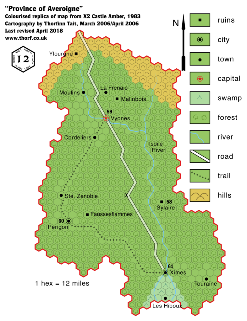
Map 5: “Province of Averoigne” from X2 (1981)
From the Atlas of Mystara:
X2 provided one of the first of many maps not actually set in the world of Mystara. This one is of the province of Averoigne in the world of Laterre, from which the d’Ambreville family fled before arriving in Glantri and establishing New Averoigne. To avoid confusion, Laterre’s Averoigne is often referred to as Old Averoigne.
The scale of 12 miles per hex is rather unique for a Mystara map, and the hex orientation is non-standard.
As a general rule, this project will not be tackling maps of worlds other than Mystara, of which a number appeared in modules over the years. But since this one provides names that were later reused in Glantri, let’s take a quick look.
Additions
- Rivers — the Isoile River and tributaries.
- Scale — the scale of 12 miles per hex is unique to this map; it’s the only published Mystaran map ever to have this scale.
- Settlements — Vyones (Capital); Périgon and Ximes (Cities); Cordeliers, La Frenaie, Les Hiboux, Moulins, Ste. Zenobie, and Touraine (Towns); Fausseflammes, Malinbois, Sylaire and Ylourgne (Ruins).
- Terrain — all new for this map.
- Trails & Roads — a single road from Ximes in the south to Vyones in the north, and leading off the map from there, as well as a single trail leading from Ximes to Périgon to Vyones.
Hex Art & Fonts
- Fonts — Helvetica for most labels, Franklin Gothic Condensed for the keyed numbers.
This brings us to the end of 1981.
[Edit: In fact, B3’s Gulluvia map also belongs in 1981 (as Map 6). But I’m afraid I overlooked it, so I will tackle it in a future article.]
1982 suffered a dearth of maps, with the only relevant one being in X3. Let’s take a look.
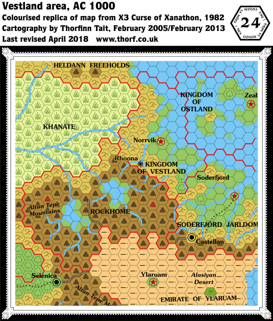
Map 7: Vestland area from X3 (1982)
From the Atlas of Mystara:
A very minor entry in the history of Known World maps, X3 reprinted a small excerpt from the original X1 Known World map, adding in the town of Rhoona.
Additions
- Settlements — Rhoona.
Textual Additions (X3 1982)
- Fjords — Rhoona is said to be located “on a sheltered fjord nearly 100 miles from the sea”, suggesting that the transition between fjord and river occurs somewhere southwest of Rhoona. The shape of the coastline on the map supports this idea, with the fjord narrowing just as it arrives at Rhoona. (p. 3)
- Leaders — the current Duke is called Stephen Rhoona. (p. 3)
- Mountain Passes — “Many steep, treacherous and hidden passes lead across the mountains to Rockhome”. (p. 3)
- Settlements — Rhoona’s population is “several thousand”. (p. 3)
I’d like to open this one up for more research, as I’m not sure I caught everything in a cursory scan through the module. Let me know if you can find anything else to add.
The Maps So Far: 1981
Head on over to the Atlas of Mystara web site, where the 1981 maps have a permanent home.
The Maps So Far: 1982
Head on over to the Atlas of Mystara web site, where the 1982 maps have a permanent home.
Finally, here’s a handy table showing the maps from 1981-1983.
Expert Set (1981) Karameikos, 6 miles per hex | Atlas of Mystara
2 November 2018 @ 11:15 pm
[…] This is Map 4. It was published in 1981. The updated version of this map has not yet been released. See also Appendix C for annual chronological snapshots of the area. For the full context of this map in Mystara’s publication history, see Let’s Map Mystara 1981-1982. […]
Expert Set (1981) Legend | Atlas of Mystara
2 November 2018 @ 11:20 pm
[…] This Legend falls between Maps 4 and 5 in the chronology. It was published in 1981. For the full context in Mystara’s publication history, see Let’s Map Mystara 1981-1982. […]
X3 Vestland, 24 miles per hex | Atlas of Mystara
2 November 2018 @ 11:31 pm
[…] This is Map 7. It was published in 1981. The updated version of this map has not yet been released. See also Appendix C for annual chronological snapshots of the area. For the full context of this map in Mystara’s publication history, see Let’s Map Mystara 1981-1982. […]
X2 Old Averoigne, 12 miles per hex | Atlas of Mystara
10 November 2018 @ 9:42 pm
[…] This is Map 5. It was published in 1981. The updated version of this map is Old Averoigne, 8 miles per hex. Since Averoigne lays outside of Mystara, there are no chronological snapshots for the area. For the full context of this map in Mystara’s publication history, see Let’s Map Mystara 1981-1982. […]
B3 Gulluvia | Atlas of Mystara
15 May 2021 @ 11:41 pm
[…] snapshots of the area. For the full context of this map in Mystara’s publication history, see Let’s Map Mystara 1981 and Placing B3’s Gulluvia […]
Karameikos, 6 miles per hex (1981) | Atlas of Mystara
19 May 2021 @ 8:46 pm
[…] Let’s Map Mystara 1981-1981 — the original project thread for this map […]
Legend (1981) | Atlas of Mystara
17 January 2022 @ 2:55 pm
[…] Let’s Map Mystara 1981-1982 — the original project thread for this map legend […]
Known World, 24 miles per hex (1982) | Atlas of Mystara
2 February 2022 @ 9:38 pm
[…] Let’s Map Mystara 1981-1982 — the original project thread for this map […]