Let’s Map Mystara 1983
In which we move through the world’s first mega expansion: 1983. Stay with me, it’s going to be a long post!
Mystara Geographic Maps 1981-1983
I’m afraid I still haven’t tackled B3 yet, but it’ll have to wait for another post.
Basic Rules Set (1983)
While there are no geographical maps and no known locations are explicitly referenced, since this set was written and released in tandem with the Expert Rules Set (1983), it can nonetheless be assumed that Threshold is the base town described in these books. Most of the details here are too large scale to be incorporated even in the 6 mile per hex maps we have of Karameikos, so for now let’s just take some notes before moving on.
Textual Additions (Basic Rules Set 1983)
- Caves — the solo adventure occurs in caves in the nearby hills, accessible by a hike from Threshold. (Players Manual p. 3)
- Ruins — Castle Mistamere is “located at the foot of the mountains to the north”, and “the outline of the broken towers can still be seen from the town”. “It lies only 3 miles from town, just a healthy walk past a local farmer’s fields”. (Dungeon Masters Rulebook p. 4)
Map 8: “The Continent” from X1 (1983)
From the Atlas of Mystara:
1983 saw the release of the revised Mentzer Expert Rules Set, along with the revised X1 The Isle of Dread.
This map is from 1983’s reprint of X1, and it is largely the same as the original 1981 map. The main changes were with labels: it changed the font (from Souvenir to Baskerville); added the missing Alfheim label; corrected the Principalities of Glantri label; and changed “Rockhome” to “Rock Home”. Two trails were also deleted, and the Legend was expanded to include the missing desert symbol, but in the process half obscures a small island. The Expert Rules Set (1983), with which X1 (1983) was bundled, reproduced the northern half of the map on a single page, cropping the Sea of Dread and the Thanegioth Archipelago while adding trails and a few other details. While it’s the same map, the small details are surprisingly different.
Perhaps the most significant addition was Threshold, which along with Kelvin was added to Karameikos.
Additions
- Settlements — Threshold and Kelvin have been added as solid black dots, but there is no entry in the legend to indicate whether this is intended as towns or villages. Referring to the legend for the same book’s Isle of Dread map suggests that they are villages.
Revisions
- Coastline — the ambiguous coastlines of Ostland’s western two islands are completely obscured by labels, whereas the 1981 map retained faint outlines of the missing parts.
- Islands — the small island south of Thyatis is half obscured by the Legend.
- Nations — Alfheim and the Principalities of Glantri are now marked correctly on the map. However, Rockhome is now “Rock Home”.
- Trails & Roads — two trails shown on the 1981 version of this map are now gone.
Hex Art
- Fonts — Baskerville.
- New Symbols — Desert (not new, but labelled in the Legend for the first time here).
Textual Additions (X1 1983)
- Nations — even though the map now has “Rock Home”, the text continues to use “Rockhome”. (p. 4)
Very minor changes from this map. Moving on to the rest of X1…
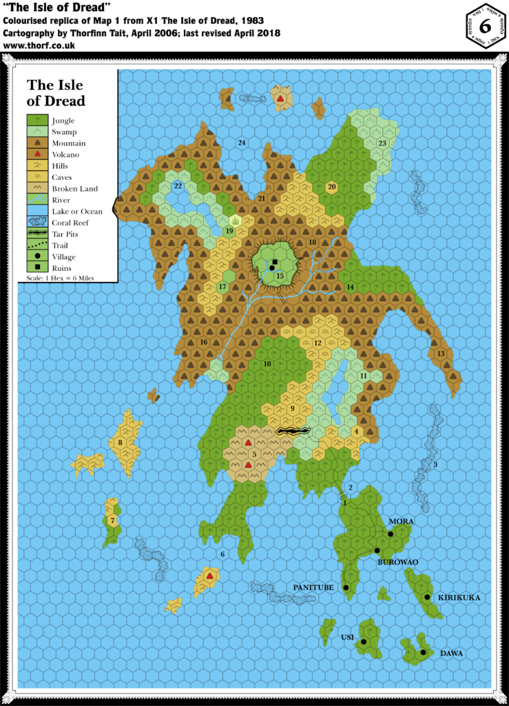
Map 9: “The Isle of Dread” from X1 (1983)
From the Atlas of Mystara:
1983’s update to X1 didn’t change the maps much. The scale problem of 1981’s map remains in place, and likely unnoticed. The surrounding ocean was expanded slightly, but not enough to include any new islands. The main innovation was the addition of village names to the map. These were provided in the text in 1981, but it was unclear which village was which; 1983’s revision placed the names on the map.
Revisions
- Reefs — the reefs flanking the label “3” on the 1981 map have been merged into a single long reef, with the label displaced to the west. However, the player’s map still has two separate reefs.
- Settlements — the villages mentioned in the text are now labelled on the map: Burowao, Dawa, Kirikuka, Mora, Panitube, and Usi.
Hex Art
- Fonts — Baskerville.
Textual Additions (X1 1983)
- Fauna — most remain the same as X1 (1981). Differences are: crocodiles at 2 (replacing bull sharks); water termite at 6 (replacing giant squid); and sea hydra at 24 (replacing sea dragon). These changes were apparently made due to these monsters being removed in the updated Expert Rulebook (1983).
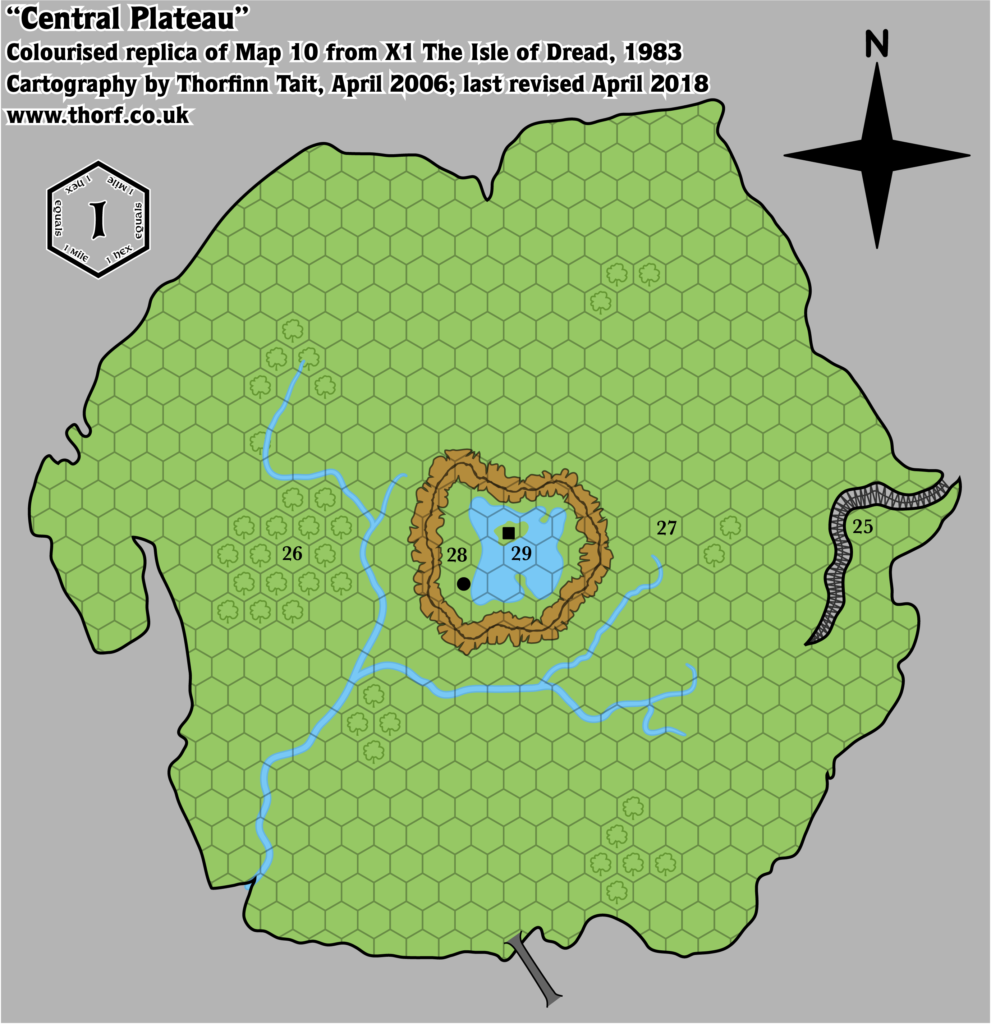
Map 10: “Central Plateau” from X1 (1983)
This map has nothing to add.
All in all, X1’s reprint changed very little and added even less — as expected. The Expert Rulebook that came in the same box as X1 adds quite a bit more. Let’s take a look at it now.
Legend from Expert Rules Set (1983)
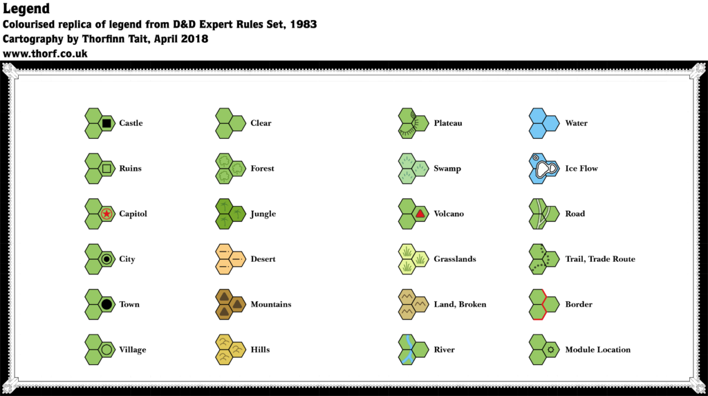
This legend appears beneath the Threshold town map, but it applies to the maps on the next two pages: the Karameikos map and the Known World regional map. These are the first maps to show both towns and villages at the same time; previously, both have been represented as a filled black circle. This contradiction is fixed now.
Hex Art
- Fonts — Baskerville.
- New Symbols — Village (unfilled black circle). The filled black circle is now only Town. Module Location (unfilled black circle with eight points radiating outwards).
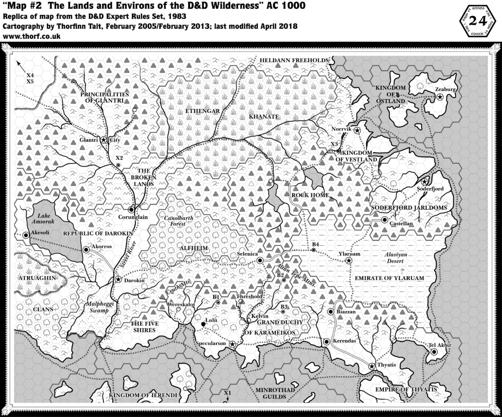
Map 11: “The Lands and Environs of the D&D Wilderness” from Expert Rules Set (1983)
From the Atlas of Mystara:
1983’s Expert Rules Set included a reprint of X1, including the seminal Known World two page map. But the Expert Rulebook also featured a single page version of this, showing the northern half of the X1 map. Trails as well as a few more towns and module locations were added, but otherwise it is identical to the earlier map.
For those who started with BECMI, this map may be even more iconic than X1’s two page version. It actually adds quite a lot of details. Let’s get stuck in!
Additions
- Module Locations — B1, B2, B3, B4, X1, X2, X3, X4 and X5 are all marked on the map.
- Rivers — the southeastern-most island, in the Empire of Thyatis, has gained a short river.
- Settlements — three unnamed villages, one each in Glantri, Rockhome and Ierendi.
- Trails & Roads — in addition to the two trails shown on X1 (1981), this map adds a whole network of trails throughout the map.
Revisions
- Coastline — Ostland is different once again, with a strange little bit of coastline marked to the right of the “OF” in “Kingdom of Ostland”. Stranger still, it actually blocks the new trail here.
- Settlements — in keeping with the same boxed set’s X1 map, Threshold and Kelvin have been added. However, Threshold’s location here is at the source of the river rather than at the fork to the south, as X1 (1983) has it. This is the beginning of Threshold’s travels around the area, as its location is shunted around again and again. Kelvin too appears slightly north of its X1 (1983) map location. Wereskalot has now changed from a castle to a village.
Hex Art
- Fonts — Baskerville.
- New Symbols — Module Location (as in the legend, but here it has a filled black dot inside the circle).
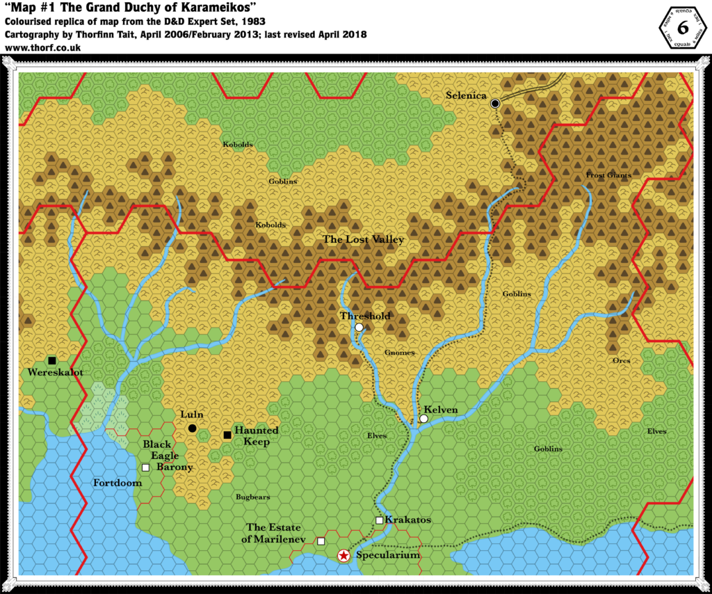
Map 12: “The Grand Duchy of Karameikos” from Expert Rules Set (1983)
From the Atlas of Mystara:
Two years after the release of the previous Expert Rulebook, 1983 saw the release of Frank Mentzer’s revised version. Coming on the heels of the Basic Rules Set, the new Expert Set continued to add to the Known World, and especially to Karameikos, although in fact the 6 mile per hex map remains largely the same.
Without question the biggest addition is the iconic village of Threshold, which now occupies a space in the foothills northwest of the gnomes. Kelvin was also added, with the spelling “Kelven” at this point — and it too is a village. Otherwise, trails were drawn connecting up some of the settlements, and the map was cropped so as to zoom in a bit more, although no new terrain is actually shown.
Additions
- Trails & Roads — the main addition from the 1981 map is the new trails, which are largely in line with those shown on the 24 mile per hex map. However, that map actually shows far more trails, including one leading from Specularum to Luln and on to Fortdoom, as well as shipping trails.
Revisions
- Caves — the caves paired with all the fauna labels on the 1981 version of this map have been replaced with regular hills.
- Rivers — the tributary east of Threshold, missed out on 1981’s map, has been restored.
- Spelling — Specularum is mis-spelled “Specularium”. Kelvin is spelled “Kelven”.
- Settlements — Wereskalot is still a castle here, despite having changed to a village on the smaller scale map (which appeared on the page after this map).
Hex Art
- Fonts — Baskerville.
- New Symbols — None.
Textual Additions (Expert Rulebook 1983)
The relevant text from the 1981 edition is repeated. Most of the additional text focuses on Threshold.
- Rulers — Duke Stefan Karameikos the Third is once again referenced. in the new text for Threshold he is also referred to as “the Archduke”. Patriarch Sherlane is the ruler of Threshold. (All p. 38)
- Settlements — Threshold, population “400 permanent residents plus over 100 other regular visitors”. However, the same page also states that “The village includes about 500 humans, 50 demi-humans, and many occasional visitors.” It is said to be “on the edge of a small lake”, and p. 31’s Threshold town map indeed shows this lake, as yet unnamed. Highdell is said to be a “small mountain outpost” situated “at the river’s beginnings” on the Specularum-Selenica trade route. This would place it two or three (24 mile) hexes south of Selenica. Tarnskeep is Patriarch Sherlane’s lakeside castle, “just north of town”. (All p. 38)
- Spelling — Kelvin is referenced multiple times, but the spelling is “Kelven”.
- Terrain — Blackstone Heath is apparently the name of an area with “an overgrown field south of town”. The Black Woods lie to “the west of town, about five miles away”. (p. 40)
- Trails — “One trail leads southeast to Kelven. The trade route between Specularum and Selenica passes through Kelven; the well-worn riverside trail leads south (to Krakatos) and north (to the small mountain outpost of Highdell, at the river’s beginnings.” (p. 39) This trail is already marked on the map.
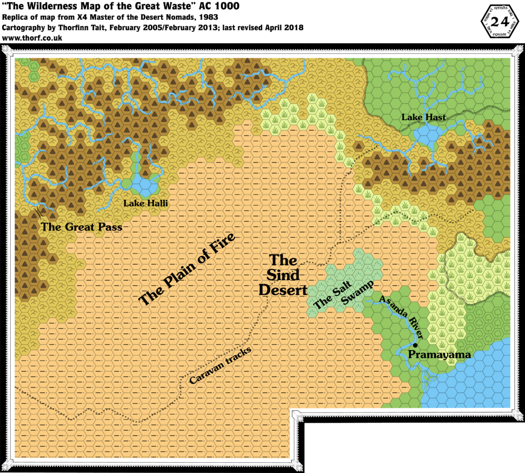
Map 13: “The Wilderness Map of the Great Waste” from X4 (1983)
From the Atlas of Mystara:
1983 and 1984 saw a massive expansion of the world, starting with X4’s Great Waste, which detailed the desert region directly to the west of X1’s Known World. It’s a sparse region, consisting mostly of desert. Sind is not yet named, although we get the village of Pramayama and the Asanda River, as well as the desert nomads of the title.
The most difficult thing about this map is the connection to X1’s map, which was vague to say the least. In fact, the lack of an overlap between these two maps made lining them up highly problematic, and it was only in 1985 with X10’s poster map that we would see the intended join.
Other highlights include the western Adri Varma Plateau (albeit as-yet unnamed), Lake Hast, the Black Mountains, and of course the Great Pass.
This map was later revised and expanded in Dragon 169, then again in Champions of Mystara.
The problematic join here can only be fully resolved with reference to future maps, so I’m going to cheat a little here and go with the join adopted by later maps. Let’s just note that this is not the only possible configuration at this point.
Additions
- Coastline — this is the first time to see the coastline of western Atruaghin and the neighbouring lands, although only a few hundred miles were shown here.
- Lakes — Lake Hast and Lake Halli.
- Mountain Passes — the Great Pass.
- Plateaus — the western half of the Atruaghin plateau (still unnamed), as well as the western section of the Adri Varma (also unnamed).
- Rivers — the Asanda River and its delta.
- Settlements — the village of Pramayama.
- Terrain — the Sind Desert, the Plain of Fire, the Salt Swamp.
- Trails & Roads — a caravan track leads through the desert, although the western end goes off the edge of the map.
Hex Art
- Fonts — Souvenir. This suggests that X4’s release (or at least production) was actually before the 1983 Expert Rules Set.
- New Symbols — Mountain Pass (two parallel lines curving away from each other at either end).
Textual Additions (X4)
- Mountains — the mountain range in the west of the map is the Black Mountains. “This massive mountain range is among the highest and most dangerous mountain chains in the known lands”. “Its peaks are permanently ice covered, and large glaciers fill many of the high valleys. From a distance the mountains appear white and dull blue, but when viewed more closely, the blue becomes dull grey, barren rock. Most of the mountain land is well above the treelike, even above the highest of the meadows that cover the lower slopes. Travel through the mountains is nearly impossible except at certain passes and trails”. (p. 18) They are largely impassable except by way of the Great Pass.
- Oasis — there is a small oasis on the caravan track called the Lost Oasis. (p. 11)
- Ruins — a Buried Temple lies “one mile across the desert (away from the caravan track)”. (p. 12)
- Settlements — an Evil Abbey is located above the treeline on the way to the Great Pass. (p. 19)
- Terrain — The Sind Desert is “more barren and stony than sandy: rocky areas, craggy bluffs, and patches of dry thorn bushes dot the landscape. During the daytime, temperatures often reach 110 degrees [43ºC] or higher. At night, the temperatures will drop as low as 30 to 40 degrees [1-4ºC].” (p.10) In the Plain of Fire “the temperatures are normally 100 degrees [38ºC] or higher during the day and only a little cooler during the night. The area is a large lava plain with many sharp rocks and blowing sand. There are no oases or wells anywhere, and only a few dried-out plants.” (p.15) The Desert Hills are a low range of hills beyond the Plain of Fire. “From a distance, the look quite barren and lifeless; however, there are many different kinds of small game, bushes, grasses, and small trees in this area. In the hills near the mountains, the trees become taller and more dense.” (p. 15) By contrast, the foothills of the Black Mountains are rather different: “bent and twisted pine grows on the land, and streams flow through the area”. “The ground, though covered with trees and grass, is dusty and rocky.” Presumably this refers to the hills leading to the Great Pass. (p. 18)
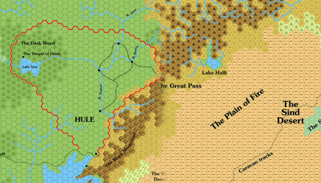
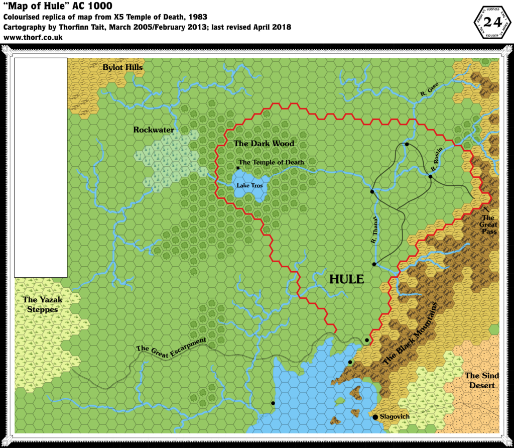
Map 14: “Map of Hule” from X5 (1983)

From the Atlas of Mystara:
X5 followed quickly after X4, and it again expanded the world westward. This time, the map included an overlap of two hex columns with the previous map, making the join between them less problematic; unfortunately, the overlapping area is not the same on both maps.
The area covered was Hule and its surrounding areas. We got our first glimpse of the Great Escarpment, as well as the Gulf of Hule area, which would be fully detailed and expanded some years later beginning in Dragon 171 and continuing through to the Savage Coast Campaign Setting.
But back in 1983, detail was somewhat scarce. Slagovich made its first appearance, and Hule itself made a barebones appearance with just a few towns and the titular Temple of Death.
Unfortunately, this area was never again shown on official maps, with the sole exception of a tantalising glimpse on the edge of Champions of Mystara‘s Great Waste map. Luckily, fans have since taken up the challenge and fully detailed Hule.
Additions
- Borders — Hule’s borders are shown, although the logic behind them is a bit opaque.
- Coastline — the northern part of the Gulf of Hule is shown for the first time, although it remains nameless at this time.
- Islands — four islands are shown in the Gulf of Hule.
- Lakes — Lake Tros.
- Mountains — the western limits of the Black Mountains.
- Plateaus — the Great Escarpment.
- Rivers — River Gree, River Rostin, River Thanat. Note that it’s not clear which river is a tributary to which.
- Settlements — seven unnamed towns, as well as Slagovich (a city) and the Temple of Death itself (marked as a filled black square).
- Terrain — the Bylot Hills, the Yazak Steppes, Rockwater, and the Dark Wood.
- Trails & Roads — although the join is not exact, the trail from X4’s map is shown to end at Slagovich. Hule’s northern four towns are connected by a network of roads.
Revisions
- Mountain Passes — the precise location of the Great Pass is almost half a hex further west than it was in X4, though its general location remains the same.

Hex Art
- Fonts — Souvenir.
- New Symbols — All-new art in a hand-drawn style, although it conforms rather well to the hex grid. Symbol-wise, the usual filled black circle is used for Town, while a larger version of the same is used for City. The Temple of Death’s filled black square is not present in the legend.
Textual Additions (X5)
- Borders — p. 10 describes the sacred forest as being “in the centre of the country”. This suggests a much larger Hule than is depicted on the map.
- Fauna — animals found in the Dark Wood “include bears, boars, deer, small game, owls, crows, ravens, toads, and bats.” (p. 15) There are also spectral hounds. (p. 16)
- Government — “Hule is a hagiarchy, a government run by “holy men” and clergy. Only humans are active in the government, although the non-humans may act as advisors to a high official.” (p. 10)
- Lakes — the map’s Lake Tros is “also known as the Lake of the Deeps“. (p. 10)
- Monuments — a Golden Cenotaph (obelisk) stands at the eastern edge of the Dark Wood, likely close to the river. (p. 15) Inside the forest, just off the “cleared path”, lies a Black Altar, a 6 foot high black stone edifice. (p.15)
- Nations — Hule, also known as the Sanctified Land.
- Plateaus — the Great Escarpment is referred to as the Risilvar Escarpment. (p. 10) This name only appears once in X5’s text.
- Races — “The population of the country is a mix of humans and non-humans, mainly orcs, gnolls, bugbears, kobolds, and ogres. All these groups seem to live and work together to some degree, although they often feud and raid one another.” Humans nevertheless seem to be the dominant race: “because the humans are so many and well-organized, nearly all the non-human tribes have allied with the government.” (p. 10) Further, demi-humans are rare: “Non-human characters (dwarves, elves, and halflings) are very rare and are objects of curiosity to the humans of Hule.” (p. 11)
- Rulers — the Master of Hule, Hosadus. (p. 12)
- Settlements — “The farmland is dotted with small villages and farming communities. These are very small and simple, and not interesting to the players. Any information peasants can give is only rumors or guesses. These villages are not located on the map.” The towns marked on the map are noted to be “bustling centres of trade” with “all the services adventurers need, including information”. (p. 10) The Temple of Death is Hule’s capital, but in Hule it is known as Greatrealm. (p. 11 and 17) It is located “not far from the shores of Lake Tros”, “on the slope of a small valley”. “The temple is a number of buildings inside a walled compound. The land around the temple is surrounded by fields.” It seems there are “many people” staying in the temple, though the exact population is not noted. (p. 17) Magden (which “contains about 4,000 inhabitants”) is the name of the first town the players enter; since this is most likely to be the one closest to the Great Pass, we will take this one to be Magden. (p. 12)
- Terrain — Most of Hule’s countryside is said to be farmland, with the “sacred forest” of Niwhelm in the “centre of the country”. This disagrees with the map on two levels: the map shows Hule’s borders as encompassing only part of this forest; and the map calls this forest the Dark Wood. Likely this is a perspective thing, like the Temple of Death/Greatrealm. (p. 10) The Dark Wood is said to be feared by local people, with no human population, and “many of the evil non-humans avoid it”. “The most common trees of the forest are oak and aspen. The underbrush in this forest is very thick. Thorn bushes abound.” “The river becomes enchanted when it enters the wood.” Those drinking the water will eventually be transformed into boars and deer. (p. 15) The map’s Yazak Steppes are referred to as the Dravish Steppes. (p. 10) As with the Risilvar Escarpment (see Plateaus above), this name only appears once in the text.
- Trails & Roads — it is implied that there is a cleared path through the Dark Wood. (p. 15) “A large path leads from the temple compound to the shore of the lake, which is out of sight of the temple”. This road is lined with statues. (p. 17)
Joining X5’s map with X4’s is slightly problematic, as although there are a number of likely looking placements, none match up exactly.
With the most logical-looking join, a total of 26 hexes differ between the maps. Of these, 12 were on the very edge of X4, only half-featured, and therefore are easy to chalk up to revisions when drawing X5’s map. The rest are either due to ambiguity in X5’s map, or just plain changes to the area shown northwest of the Black Mountains.
The rules of the project state that we replace the older hexes with the new, so we will adopt all of X5’s hexes for this join. Looking ahead to this area’s next appearance, ten years later in 1993’s Champions of Mystara, it looks as if that map did the same thing. But that’s getting ahead of ourselves.
The rivers are actually far less compatible, and it seems plain that the rivers on the edge of X4’s map were revised to better fit the terrain introduced in X5. Champions actually went for a compromise, adding some parts of X4’s rivers to X5’s systems. For now, we will simply go with X5’s, archiving X4’s for future reference.
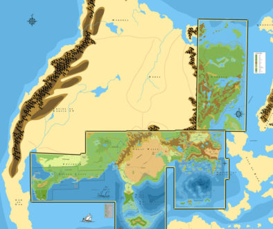
The Maps So Far: 1983
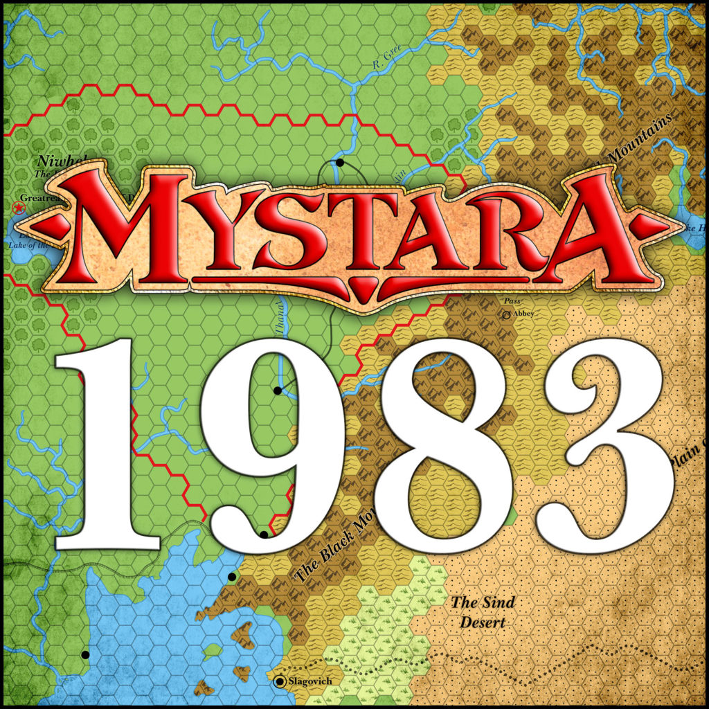
This brings us to the end of 1983. I’ve changed all the labels to Baskerville, the font of the BECMI era. We’ll likely stay with it until we reach the Gazetteer era in 1987. Now let’s take a look at the combined maps up to this point.
Head on over to the Atlas of Mystara web site, where the 1983 maps have a permanent home.
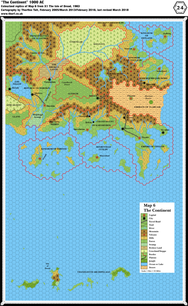
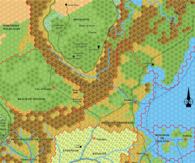
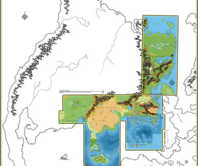
Finally, here’s what’s coming up in the next post, where the expansion continues in 1984.
Let’s Map Mystara 1984 – Thorfinn Tait Cartography
20 June 2018 @ 9:00 pm
[…] to a misalignment of X1’s map with X4’s — which would be entirely unsurprising, given what we saw in the last post on this very […]
26 September 2018 @ 11:06 pm
Hi Thorf, was wondering if you did a replica/update of the map to Threshold from the Mentzer Expert book or from the maps in Gaz1. Running a new campaign in the KW using 5e and wanted a nice map to go with it. Fantastic work.
Isle of Dread, 4 miles per hex (1983) | Atlas of Mystara
7 August 2021 @ 9:00 pm
[…] Let’s Map Mystara 1983 — the original project thread for this map […]
X1 (1983) Known World, 24 miles per hex | Atlas of Mystara
8 August 2021 @ 7:10 pm
[…] This is Map 10. It was published in 1983. The updated version of this map has not yet been released. See also Appendix C for annual chronological snapshots of the area. For the full context of this map in Mystara’s publication history, see Let’s Map Mystara 1983. […]
X1 (1983) Isle of Dread, 6 miles per hex | Atlas of Mystara
8 August 2021 @ 7:31 pm
[…] This is Map 11. It was published in 1983. The updated version of this map has not yet been released. See also Appendix C for annual chronological snapshots of the area. For the full context of this map in Mystara’s publication history, see Let’s Map Mystara 1983. […]
X1 (1983) Central Plateau, 1 mile / hex | Atlas of Mystara
8 August 2021 @ 7:38 pm
[…] This is Map 12. It was published in 1983. The updated version of this map has not yet been released. See also Appendix C for annual chronological snapshots of the area. For the full context of this map in Mystara’s publication history, see Let’s Map Mystara 1983. […]
Expert Set (1983) Legend | Atlas of Mystara
8 August 2021 @ 7:47 pm
[…] This Legend falls between Maps 14 and 15 in the chronology. It was published in 1983. For its full context in Mystara’s publication history, see Let’s Map Mystara 1983. […]
Expert Set (1983) Known World, 24 mph | Atlas of Mystara
8 August 2021 @ 8:06 pm
[…] This is Map 13. It was published in 1983. The updated version of this map has not yet been released. See also Appendix C for annual chronological snapshots of the area. For the full context of this map in Mystara’s publication history, see Let’s Map Mystara 1983.SaveSaveSaveSaveSaveSaveSaveSaveSaveSave […]
Expert Set (1983) Karameikos, 6 mi/hex | Atlas of Mystara
8 August 2021 @ 8:12 pm
[…] This is Map 14. It was published in 1983. The updated version of this map has not yet been released. See also Appendix C for annual chronological snapshots of the area. For the full context of this map in Mystara’s publication history, see Let’s Map Mystara 1983.SaveSaveSaveSaveSaveSaveSaveSaveSaveSave […]
X4 Great Waste, 24 miles per hex | Atlas of Mystara
8 August 2021 @ 8:22 pm
[…] This is Map 8. It was published in 1983. The updated version of this map has not yet been released. See also Appendix C for annual chronological snapshots of the area. For the full context of this map in Mystara’s publication history, see Let’s Map Mystara 1983.SaveSaveSaveSaveSaveSaveSaveSaveSaveSave […]
X5 Hule, 24 miles per hex | Atlas of Mystara
8 August 2021 @ 8:56 pm
[…] This is Map 9. It was published in 1983. The updated version of this map has not yet been released. See also Appendix C for annual chronological snapshots of the area. For the full context of this map in Mystara’s publication history, see Let’s Map Mystara 1983.SaveSaveSaveSaveSaveSaveSaveSaveSaveSave […]
Known World, 24 miles per hex (1983) | Atlas of Mystara
11 August 2021 @ 10:06 pm
[…] Let’s Map Mystara 1983 — the original project thread for this map […]
Great Waste, 24 miles per hex (1983) | Atlas of Mystara
12 August 2021 @ 9:01 pm
[…] Let’s Map Mystara 1983 — the original project thread for this map […]
Brun, 24 miles per hex (1983) | Atlas of Mystara
13 August 2021 @ 11:39 pm
[…] Let’s Map Mystara 1983 — the original project thread for this map […]
Legend (1983) | Atlas of Mystara
17 August 2021 @ 8:02 pm
[…] Let’s Map Mystara 1983 — the original project thread for this yearSaveSaveSaveSaveSaveSaveSaveSave […]
Threshold (1983) | Atlas of Mystara
4 January 2022 @ 1:30 pm
[…] Let’s Map Mystara 1983 — the original project thread, though this map was not included at the time […]
Karameikos, 6 miles per hex (1983) | Atlas of Mystara
4 January 2022 @ 1:33 pm
[…] Let’s Map Mystara 1983 — the original project thread for this map […]
Hule, 24 miles per hex (1983) | Atlas of Mystara
11 January 2022 @ 4:37 pm
[…] Let’s Map Mystara 1983 — the original project thread for this map […]
Expert Set (1983) Legend | Atlas of Mystara
15 January 2022 @ 6:49 pm
[…] This Legend falls between Maps 14 and 15 in the chronology. It was published in August 1983. For its full context in Mystara’s publication history, see Let’s Map Mystara 1983. […]
The Multiverse (1984) | Atlas of Mystara
12 February 2022 @ 8:19 pm
[…] Let’s Map Mystara 1983 […]
Expert Set Threshold town map | Atlas of Mystara
27 February 2022 @ 8:01 pm
[…] This is a town map. It was published in August 1983. The updated version of this map has not yet been released. See also Appendix C for annual chronological snapshots of the area. For the full context of this map in Mystara’s publication history, see Let’s Map Mystara 1983.SaveSaveSaveSaveSaveSaveSaveSaveSaveSave […]
Central Plateau, 0.5 miles / hex (1983) | Atlas of Mystara
24 September 2023 @ 11:43 am
[…] Let’s Map Mystara 1983 — the original project thread for this map […]