Let’s Map Mystara 1984
1984 was a truly bumper year for Mystara: more than fifteen maps in nine different books expanded the world in all sorts of ways. It’s not surprising, then, that this post took almost two months to write.
But here it is at last. So without further ado, let’s get stuck in — beginning with a table showing all the maps from 1984.
Mystara Geographic Maps 1984
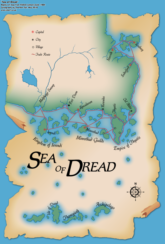
Map 15: “Sea of Dread” from XSOLO (February 1984)
From the Atlas of Mystara:
XSOLO was the first D&D product released in 1984. Where previous solo adventures had not included much in the way of setting details, XSOLO is positively brimming in them — though the nature of the adventure means that the map is largely unlabelled, so most of the detail is in the text.
It also marked the first time the Sea of Dread was referred to by its iconic name. It’s funny to think that it took until 1984 for this to happen.
The map itself is a player handout, with a rather pretty parchment design, reducing details down to those relevant to the adventures in XSOLO.
Additions
- Islands — in addition to the islands of the Sea of Dread shown on the original X1 map, an island has been added in the southeast.
- Seas — though Lawrence Schick stated that it was present in the original map that inspired the Known World, XSOLO marks the first appearance of the name Sea of Dread in published works.
- Settlements — three villages have been added, one in Minrothad and two on what the text calls the “Thyatic peninsula”.
- Trade Routes — the map expands the shipping lanes shown on 1983’s Expert Set map to include the regions that were cropped on that map, notably southern Ierendi, Minrothad, and Thyatis.
Revisions
- Coastline — the coastline is not a perfect fit with previous maps. Notably, all of the small islands have been increased in size by a factor of three or four.
Hex Art & Fonts
- Fonts — Romic (title), Quill (labels). This is the first appearance of both these fonts.
- New Symbols — Trade Route (solid red line).
Textual Additions (XSOLO 1984)
- Battles — the Aquapopulus War, a legendary war with the merpeople, with a battlefield on Skeleton Key in the Sea of Dread. (p. 11, 13, 19)
- Climate — easterly winds seem to prevail in the Sea of Dread. (p. 27) A hurricane in the east is used to pen the PC in and prevent them from leaving the play area. It seems the Sea of Dread is prone to storms and hurricanes. (p. 30 etc)
- Fauna — “rare seven-headed hydras” in the Malpheggi Swamp and the Sea of Dread. (p. 11) Salt water termites at Termite Atoll. (p. 19)
- Islands — Burning Mountain is located northeast of the easternmost Thanegioth Archipelago island. It seems to be a single mountain jutting out of the sea, whose eruptions include chunks of molten gold (p.13, 15, 19-21); East Key is the easternmost small island on the map (p. 19); Insect Island is an island infested with worms and beetles southwest of Termite Atoll (p. 19); No Name Island is in the centre of the map, “little more than a sand bar that has inedible plants growing on it” (p. 19); Pirate Rock is the island south-southeast of No Name Island (p. 11, 20); Skeleton Key is northwest of the Isle of Dread, “a small, tropical coral island” (p. 25) covered with thousands of bones leftover from the Aquapopulus War (p. 19); Spider Isle is the island directly north of the Isle of Dread (p. 11, 19); Termite Atoll is the closest island south of Ierendi (p. 19); the Three Sisters Keys are the westernmost islands on the map (p. 15, 19). Most of the islands are referred to as “small tropical island[s]” (p.25-26).
- Reefs — the Dragon’s Teeth are referred to in numerous entries. The Three Sisters Keys are said to be “over the Dragon’s Teeth reef”. The reef starts northwest of the Isle of Dread, skirting Skeleton Key before turning north and continuing until close to Ierendi. (p. 15, 25-26 etc)
- Ruins — the Lost Temple of Araknee, “an ancient holy shrine” located on Spider Isle. It is an “ancient building surrounded by eight standing pillars” in “the centre of the island”. “The roof of the building is shaped like the body of a spider. Cobwebs stretch between the building’s pillars.” (p. 11, 19)
- Rulers — Baron von Hendriks is the instigator of the plot of this module.
- Seas — the Gulf of Halag is once again name-called. (p. 22)
- Settlements — the Minrothad village shown on the map is “a tiny village in the Minrothad Guilds” (p. 15) and “a small fishing village (p. 24). The Ierendi village is similarly as “a small village” (p. 15) and “a small fishing village” (p. 23). The villages in Thyatis are both referred to as “a small fishing village”. (p. 22, 24)
- Terrain — the island that will later be called Hattias is referred to as the “Thyatic peninsula”. It seems that the channel between this island and the mainland is still being thought of as a canal. (p. 13, 15, 22)
- Whirlpool — a “massive whirlpool” is located just north of the easternmost island of the Thanegioth Archipelago. (p.29)
Analysis
XSOLO marks the first published used of “Sea of Dread”, as noted above. But it also appears to include the first reference to the Known World — albeit uncapitalised, and used in a general sense opposed to “the unknown”, which in XSOLO means everywhere off the edge of the map and therefore out of the play area.
Since this map is by design a player handout, and since it doesn’t perfectly fit with other maps of the area, I am going to interpret it with a grain of salt. Specifically, I think the size of the islands shown on the map is far too large when compared to both the text of XSOLO as well as the original X1 map’s version of those islands.
My solution is to use the slightly clearer shapes of the islands from this map, but shrink them down to a size close to the X1 version of the islands. I’ll also adjust their locations to match X1’s island locations.
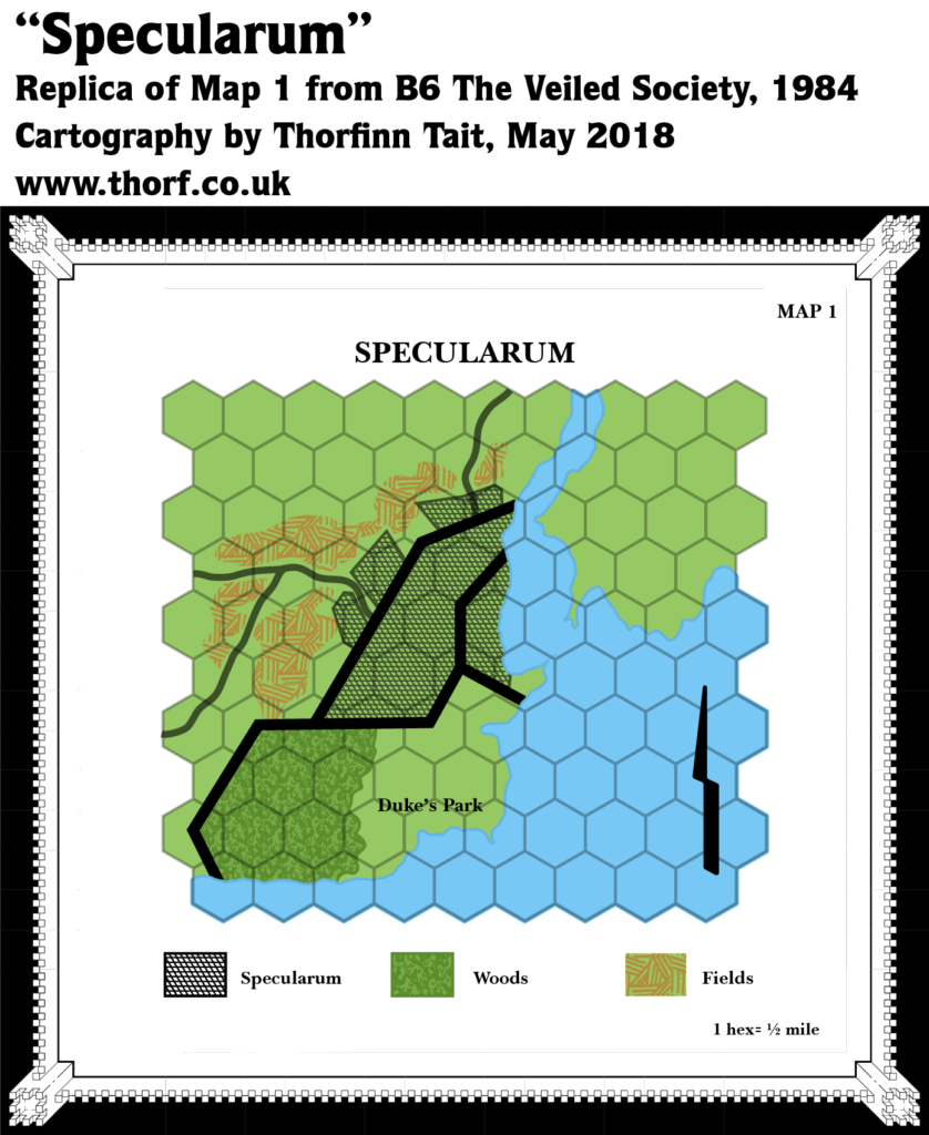
Map 16: “Specularum” from B6 (March 1984)
From the Atlas of Mystara:
Most of the B series modules concentrated on dungeon adventures, and so by definition lacked overland maps beyond a very local scale. 1984’s B6 was an exception to this rule, as it included not just a city map for Specularum, but also a half mile per hex large scale map of its immediate surroundings.
The entire area depicted would fit inside a single 6 mile hex quite neatly, and the hex map’s Specularum doesn’t quite line up with the town map itself. But it still gives a nice view of an area central to the setting.
The town map for Specularum was completely redone a few years later, but this map never received a corresponding update.
Additions
- Terrain — Duke’s Park south of Specularum.
- Trails & Roads —Two roads are shown leaving Specularum, going north and west. The western road splits into two almost immediately, with one continuing west while the other veers southwest.
Revisions
- Coastline — the coastline around Specularum is rather different from that shown on previous maps in X1 and the Expert Sets.
- Settlements — Specularum is shown in some detail, although it doesn’t really match up very well with the even more detailed town map also provided in B6.
Hex Art & Fonts
- Fonts — Baskerville.
- New Symbols — Compass Rose (stylised lightning bolt), Fields (cross-hatched lines), Woods (treetop-like texture inside irregular shape), Urban Area (a diagonal grid of small diamonds), City Walls (solid thick black lines).
Textual Additions (B6 1984)
- Dominions — the Estate of Marilenev, which was marked on both Expert Set Karameikos maps attached to a castle symbol, is here said to be “a holding that surrounds the city”. (p. 2)
- Rulers — Duke Stefan Karameikos the Third is once again stated to be the ruler of Karameikos.
- Settlements — lots of details about Specularum. Its population of 5,000 plus 500 soldiers is restated here. It is also re-confirmed as being a port on the coast, while “a large river east of the city allows ships to carry cargos inland to other towns”. (p. 2)
Analysis
This is a nice little addition to Karameikos, although it’s a little too large scale to be that useful.
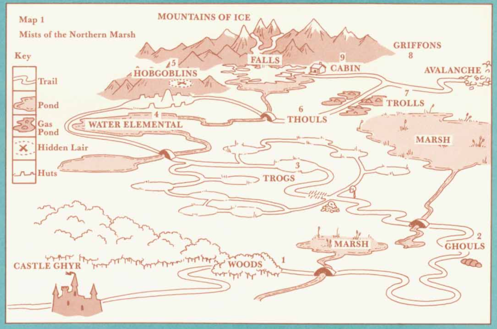
Map 17: “Map 1 Mists of the Northern Marsh” from XL-1 (March 1984)
Additions
- Bridges — the trail winding through the marsh has four bridges on it, all unnamed.
- Fauna — ghouls, troglodytes, water elemental, hobgoblins, thouls, trolls, and griffons.
- Mountains — the Mountains of Ice.
- Nations — Ghyr.
- Settlements — Castle Ghyr in the southwest corner of the map, and a solitary cabin at the foot of the Mountains of Ice in the north. The hobgoblins have a hidden lair in the mountains, south of which some huts are marked.
- Terrain — the area shown is the Northern Marsh, between Castle Ghyr in the south and the Mountains of Ice in the north. In between are various details of the Northern Marsh, including marshes, woods, rivers, waterfalls, ponds, and “gas ponds”. None of these are named individually.
- Trails & Roads — a trail is shown winding through the terrain of the Northern Marsh.
Art & Fonts
- Fonts — Baskerville.
- New Symbols — the map is hand-drawn.
Textual Additions (XL-1 1984)
- Battles — the Prism Wars, for which Old King Ganto was “best known for his victories”.
- Climate — the Northern Marsh is shrouded in mist and rain. (p. 4)
- Government — Ghyr is a monarchy governed by a king with his Royal Council. It also has a High Patriarch in charge of the faith of Ghyr (“He Who Watches). (p. 2-3)
- Nations — “As the countries surrounding Ghyr fought among themselves, Ganto kept his northern kingdom out of war.” (p. 2) It would seem that Ghyr lies to the north of a group of warring nations.
- Rulers — Old King Ganto is the king who just died “with no legal heir”, leaving his queen, Leahra to take over and appoint a successor. (Can’t she just rule herself?) Ganto was 82, and he was king for 37 years. (p.2) King Qasmar was “the King of Ghyr during the Prism Wars”; presumably he was Ganto’s predecessor. (p. 3)
- Scale — the map’s scale is entirely unmarked, though the adventure’s content tends to suggest that the Northern Marsh, while “vast” (p. 3), also doesn’t take all that long to travel through.
- Settlements — the hobgoblins’ hidden lair turns out to be much closer to their six-hut settlement. (p. 5)
- Terrain — the “great Mountains of Ice” — implies that they are formidable peaks. (p. 3) The Northern Marsh is referred to as “the Mists”, a “vast foggy marsh” at the foot of the Mountains of Ice. (p. 3) The journey from Castle Ghyr begins “through the eastern forest”. This is peculiar, since most of the forest lies north of Castle Ghyr. One possibility is that the forest extends west outside the border of the map. (p. 4)
Analysis
The burning question is: where should Ghyr be placed?
There’s no easy answer to this — especially at this point in early 1984, when the world is still in its infancy. The warring kingdoms to the south of Ghyr make it an unlikely fit anywhere on contemporary maps, although at the same time its size means it could freely be placed almost anywhere.
I’m going to leave this entirely open for now.
Moving on, 1984’s first major expansion of the world came in June — and what an expansion it was: three books (X6, the Companion Set, and CM1) added large areas in the north and south, as well as drawing in the full continental map.
Let’s start with X6. I’ll go through the maps one by one before examining the text itself.
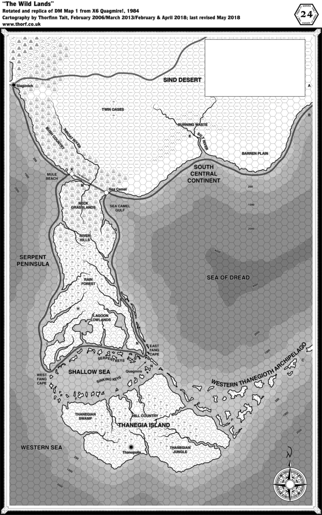
Map 18: “DM Map 1 The Wild Lands” from X6 (June 1984)
From the Atlas of Mystara:
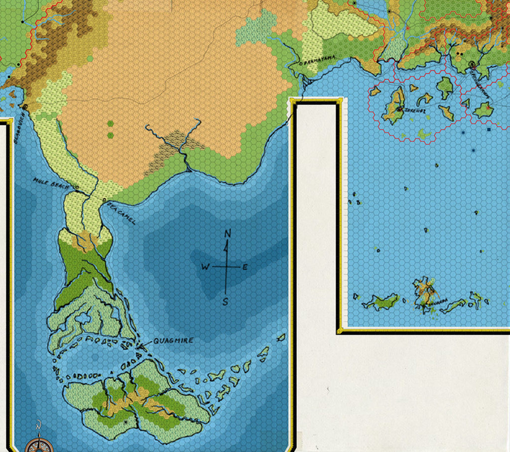
Continuing 1984’s mega-expansion, X6 detailed the lands south of X4’s Great Waste. Known in X6 as the Wild Lands, this region later came to be called the Serpent Peninsula.
The map was seminal in its own way: it marked ocean depths for the first time in a Mystara map. This was continued in some later maps, but often in a less obvious way, such as with textual depth labels rather than shading.
The Western Thanegioth Archipelago came as a shock to some, as it now turned out that the Isle of Dread and its archipelago were less isolated than they had at first appeared to be.
Finally, Slagovich makes its second appearance, this time along with the wonderfully banal Mule Beach and Sea Camel.
Additions
- Bays — Sea Camel Gulf. Also Mule Beach, although this label is ambiguous and could refer to the village. (See below.)
- Coastline — other than the area immediately around Slagovich, everything here is new. The eastern edge doesn’t quite reach the area shown on X4 south of Pramayama.
- Depths — labelled depths for the whole area.
- Islands — this map introduced a plethora of islands, including the Serpent and Sinking Keys of the Shallow Sea, the Western Thanegioth Archipelago, and the vast island of Thanegia.
- Lakes — three unnamed lakes in the Lagoon Lowlands, although it’s not entirely clear if they are true lakes or inlets.
- Rivers — Silt River, Throat River, and a quite a few unnamed rivers on the Serpent Peninsula and Thanegia Island.
- Seas — the Western Sea makes its first appearance. The northwestern corner of the map joins up with the bay shown on the southern edge of X5’s map, making this a major bay on the Western Sea. The Shallow Sea is the small sea between the Western Sea and the Sea of Dread, encircled by numerous islands as well as the Serpent Peninsula to the north and Thanegia Island to the south.
- Settlements — Sea Camel. Mule Beach looks to be the name of the other village but the label is a bit ambiguous on this map. (See below.) Thanopolis is the only settlement marked on Thanegia Island, and it’s a city. Quagmire is labelled but with no icon.
- Terrain — Twin Oases, Burning Waste, Barren Plain, Bush Country, Neck Grasslands, River Hills, Rain Forest, Lagoon Lowlands, East and West Fang Capes, Thanegian Swamp, Hill Country, and Thanegian Hills.
- Trails & Roads — shipping trails from Slagovich to Mule Beach, round the Serpent Peninsula through the Shallow Sea and then to Sea Camel, then onwards towards the Known World region. Also the Necklace is a trail across the neck of the Serpent Peninsula.
Revisions
- Coastline — the only bit of coastline previously shown is that around Slagovich. X6’s version seems to be straighter than X5’s in the bay north of Slagovich, but they’re largely compatible.
- Trails & Roads — the caravan tracks through the Sind Desert to Slagovich were shown in two parts in X4 and X5, but the actual join is shown here. The course of the route is slightly different, but largely compatible.
Hex Art & Fonts
- Fonts — Arnold Boecklin (title); Helvetica (everything else).
- New Symbols — a new Compass Rose; water depths (shaded bands of hexes in the sea); trade Route (solid thick black line).
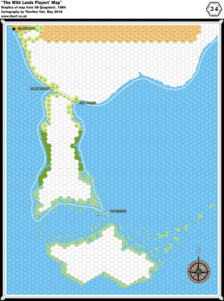
“The Wild Lands Players’ Map” from X6 (June 1984)
The players’ map followed in the footsteps of X1’s players’ map, providing the coasts but with inland areas blank. The content of the map is almost identical to the DM’s map, although cropping is slightly different. The other large difference is that this map was full colour.
Revisions
- Coastline — the peninsula west of Slagovich was cut off on the DM’s map, but appears here in full. It’s slightly more pointy than X5’s version of the same peninsula.
- Settlements — Mule Beach is clearly marked as the village name here.
Hex Art & Fonts
- Fonts — Arnold Boecklin (title); Helvetica (everything else).
- New Symbols — no new symbols, but the colours used were rather non-standard, with yellow swamps, dark green jungles, and paler green grasslands.
Map 19: Parchment map from X6 (June 1984)
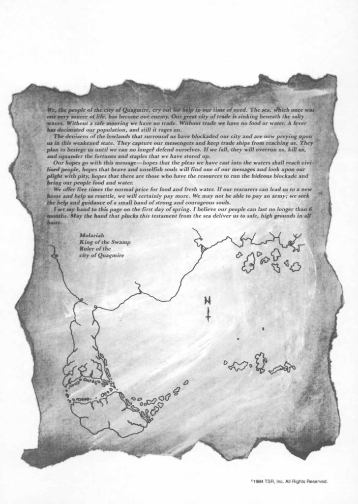
A very simple map, this simple coastal outline provides the first full picture of the coastline from Slagovich in the west all the way to Specularum in the east.
Additions
- Coastline — the small missing section of coastline linking X6 and X4’s hex maps is provided on this map.
Analysis
There’s an interesting article by Jon Peterson recounting the development of X6 by Merle Rasmussen. It includes a sketch of the area, which was traced to create this parchment map player handout.
Interestingly, comparing the original sketch with the parchment map reveals that the parchment version has been rotated quite a bit — likely to make it fit the parchment nicely.
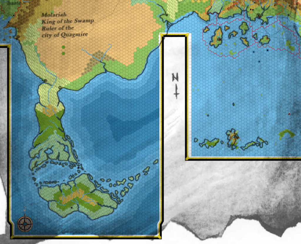
As a result, the parchment map has to be rotated back in order to fit on top of the combined X1-X6 maps:
The rotation is about 1.9º. As you can see, the fit is rather snug — with the exception of the Asanda River delta, which ironically is exactly the area we are missing at this point.
Here’s how the original sketch lines up:
The fit is almost identical; the difference lies in the lack of rotation, as here the map has been overlaid without any kind of rotation needed.
In any case, I would theorise that the misalignment of the Asanda delta here is due to a misalignment of X1’s map with X4’s — which would be entirely unsurprising, given what we saw in the last post on this very topic.
So the conclusion here is not to use these maps as a source here just now. Besides, the continental map was also released this month, in June 1984, so let’s wait and see how that turns out in a moment.
X6 had one more map:
Map 20: “DM Map 2” from X6 (June 1984)
From the Atlas of Mystara:
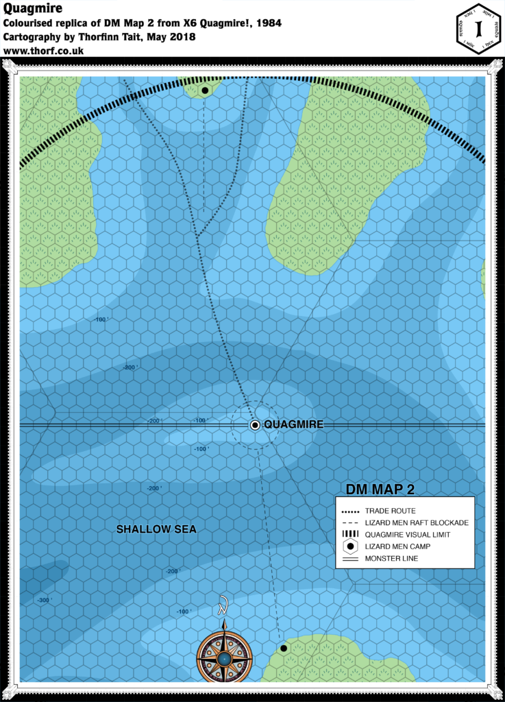
X6 included a large scale hex map detailing the area immediately around the sinking city of Quagmire. It’s one of only a few 1 mile hex maps that appeared in Mystara’s products over the years. The map itself is unfortunately rather bare, failing to provide any new detail to the area other than slightly more detailed coastlines and deep water contour lines.
Additions
- Depths — X6’s other maps provided general bathymetry, but here we have more detailed contour lines for the sea floor.
- Monster Line — a line bisecting the map.
- Settlements — the precise location of the city of Quagmire, along with two lizard men camps.
Revisions
- Coastline — precise coasts of the islands were slightly more detailed than in the 24 mile per hex map.
- Trails & Roads — the trade routes on the smaller scale map are shown to lead to Quagmire on the way through the Shallow Sea.
Hex Art & Fonts
- Fonts — Helvetica.
- New Symbols — Visual Limit (a thick, finely dashed line), Raft Blockade (a dashed line), Monster Line (two parallel lines).
Textual Additions (X6 1984)
- Climate — “The general weather patterns of this part of the world move from east to west. The world’s equator lies just south of Thanegia Island. The climate of this area is similar to that of Florida or Cuba.” Hurricanes are also a possibility in this area. (p. 4)
- Currents — Narrow channels run from the Sea of Dread past the city of Quagmire into the Shallow Sea, from which more channels “run past a handful of islands” into the Western Sea. (p. 4)
- Fauna — rhinoceros in the Bush Country and Neck Grasslands (p. 6); camels in the Barren Plain, Burning Waste and Sind Desert — notably the Twin Oases (p. 6, 11); wild horses in the Bush Country or Neck Grasslands (p. 6, 11); mules in the Barren Plain, Burning Waste (!), Bush Country, Neck Grasslands or the River Hills (p. 6, 11); grab grass in the Bush Country and Neck Grasslands (p. 6, 11); killer trees in the Rain Forest and Thanegian Jungle (p. 6, 11); rock baboons in the Burning Waste (p. 19).
- Islands — quite a few islands are introduced here:
- the Serpent Keys are “low, swampy islets” just off the coast of the Lagoon Lowlands. The trade route runs between the keys and the lowlands. “Some of the smaller keys are no more than offshore sandbars. Most of these keys have muddy coastlines.” (p. 4)
- The islands running along the north coast of Thanegia Island are the Sinking Keys. “These keys are little more than sandbars covered by swampy vegetation. … The coasts of these keys tend to be muddy and swampy.” (p. 4)
- Thanegia Island‘s history is shrouded in mystery, though “Legends speak of the Yavdlom, an early race of man that lived here in harmony with the island’s natural beauty.” They are said to have moved on to other lands due to an unknown force — which is then stated to have been the slow sinking of the land in the area that’s now the Shallow Sea. (p. 4)
- the Western Thanegioth Archipelago “stretches northeastward from Thanegia Island’s eastern coast. These low, swampy isles support more exotic forms of life than their sister islands to the east. Even though most of these isles are swampy, their coastlines are sandy.” (p. 4)
- Monster Line — this is a functional line in the adventure, dividing the region in two for the purpose of wandering monsters. (p. 2)
- Placement — there’s a detailed note on placing the maps together on p. 2. It states that the “eastern edge of DM Map 1 in this adventure is situated 11 hexes west of the Continent Map on p. 16-17 in adventure X1”, and also that “you may line up the top 3 1/2 hex rows of DM Map 1 from this adventure so that they overlap the bottom 3 1/2 hex rows on the Map of the Great Waste” from X4.
- Regions — the Wild Lands is defined as “portions of the continent, Serpent Peninsula, Thanegia Island, and the surrounding seas” — essentially everything shown on the map. (p. 2) The label South Central Continent appears on DM Map 1, and the text says that this area of land “includes the city of Slagovich, Bush Country, the Sind Desert, the Burning Waste, and the Barren Plain.” (p. 3)
- Rulers — Molariah, King of the Swamp, Ruler of the city of Quagmire. (p. 5)
- Scale —
- Seas — the Sea of Dread is defined here as being bordered “by the continent to the north, Serpent Peninsula to the west, and the Thanegioth Archipelago to the south”. Sea Camel Gulf is “a northwest extension of this sea”. The Shallow Sea used to be land connecting the Serpent Peninsula to Thanegia Island, but the land subsided some time ago, creating this sea. The Western Sea is the name of the sea west of the Serpent Peninsula, bordered on the north by the Gulf of Hule, which here gets its name for the first time. (All p. 4)
- Settlements — X6 details more settlements than any previous adventure:
- Quagmire, Thanopolis and the Sunken City are all thirteen-level spiral cities sharing the same configuration (and the same map). (p. 2, 21-27)
- Quagmire is said to be a “rich trading capital”. (p. 5) It is still populated by its original inhabitants (presumably the Yavdlom people), of whom a total of 42 remain. The city is sinking.
- Thanopolis has been taken over by humanoids (gnolls, trolls and goblins). The people of Quagmire wish to resettle here.
- The Sunken City was previously known as Yavdlom. (p. 20) It is now inhabited by mermen.
- Slagovich is described as an “opulent, Western Sea trading port” at “the western end of the Sind Desert Caravan Track”, where “all kinds of exotic goods” are traded. It is a “hilly city” whose “rocky port features excellent, deep harbour facilities”. (p. 3) “Merchants fill the streets, hawking their goods. The city wharf never sleeps, as ships load and unload throughout the day and night. Slagovich is a stopping place between Hule to the north and Mule Beach to the south. A ship either arrives or leaves Slagovich every day. Camels are everywhere around Slagovich. If characters ask, they find out that caravans leave weekly on 1,900-mile treks across the Sind Desert to Akesoli in the Republic of Darokin. Other caravans wind even further, going an extra 300 miles to Glantri City in the Principalities of Glantri.” (p. 20)
- There are Stilt Villages along Thanegia River banks, each with 30-300 natives. (p. 6, 12-13)
- Mule Beach is a “dusty-brown trading village” standing “at the spot where the Throat River empties into the Western Sea”. It is said to be well-known thanks to its position at the western end of the Necklace trade route. (p. 20)
- Sea Camel is alternately described as a “solitary jewel of a city” and a “tiny, clean village”. It sits at the eastern end of the Necklace. It has “white walls and red-tiled roofs” and “an excellent, deep harbour”. (p. 20)
- Quagmire, Thanopolis and the Sunken City are all thirteen-level spiral cities sharing the same configuration (and the same map). (p. 2, 21-27)
- Terrain — the text has descriptions for a large number of terrain features:
- Bush Country is the land from Slagovich to the Neck Grasslands. It has “a sandy shoreline”, and is home to “various types of wildlife” as well as nomadic hunters. (p. 3)
- the Sind Desert is once again described, this time as “more barren and stony than sandy”, with “rocky areas, craggy bluffs, and patches of dry thorn bushes”. (p. 3)
- the Burning Waste is a region of “craggy, eroded rocks” that lies “over an active geothermal subsurface”. “Minor quakes and avalanches rock this area frequently, and geysers and tarpits are common. The shifting rocks of the waste occasionally release natural gases, which then burst into flame. These gases burn for weeks, sending dark clouds of smoke into the desert sky. Because of the area’s violent, unpredictable terrain, there are no permanent dwellings or communities in the Burning Waste. Pitch, which is used for sealing ships, is the area’s only valuable commodity.” (p. 3)
- the Barren Plain is a “sandy, rolling stretch of land” that is “warm and windy”, with little plant or animal life and a rocky shoreline. The Silt River “cuts the plain in half”. It is “known for its inclement weather”. (p. 3)
- the Serpent Peninsula is said to get its name either from “the serpentine trade route that ships must follow along its coast” or as “a reference to the large number of snakes that live throughout the area”. The Necklace caravan route separates the peninsula from the continent. (p. 3) It also includes the following areas:
- the Neck Grasslands, named for “the narrow isthmus they cover”, are “teeming with several kinds of dangerous creatures”. “Both of this area’s coastlines are sandy”. (p. 3)
- the River Hills are covered with grass and trees, and “many of the peninsula’s meandering rivers start here and run down into other types of terrain in the form of waterfalls”. (p. 3)
- the Rain Forest is drenched with daily thunderstorms, with muddy coasts to the east and west. (p. 3)
- the Lagoon Lowlands are a “sticky region” with three “large, freshwater lakes”. “The land of this marshy bog gives with each footstep. The earth here is so low and swampy that it is difficult to tell where the muddy coastlines end and the swampy lands begin. Seawater mingles with the roots of gnarled trees along the coasts.” (p. 4)
- the Fangs are “muddy points of land” that are the southeast and southwest tips of the peninsula, used as landmarks by traders. (p. 4)
- on Thanegia Island:
- the Thanegian Swamp “forms the coastline for the entire island, and is only broken by a few slow rivers”. Unlike the Lagoon Lowlands, there are no fresh-water lakes in this swamp. (p. 4)
- the Thanegian Jungle is like the Rain Forest, but with “a greater variety of plant and animal life”. (p. 4)
- the Hill Country is far inland, out of sight of the coasts. “Grass and trees cover these rolling highlands. All of the island’s rivers flow from these hills.” (p. 4)
- Trade Routes — the Necklace is “the ancient land trade route that separates Serpent Peninsula from the continent”. (p. 20)
Analysis
The placement rules given in the text don’t seem to line up properly — specifically the 11 hexes between X1 and X6’s maps. On the other hand, the sketch map and parchment map line up fine, so I will ignore the text in this instance as it seems I have the placement correct anyway.
The map fits quite well with 1983’s combined maps.
Map 21: Continental map from Companion Set (June 1984)
From the Atlas of Mystara:
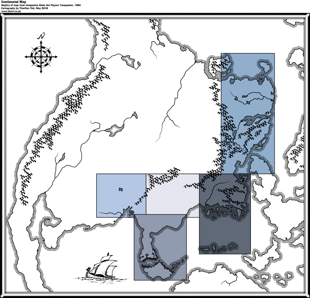
The first glimpse of the Known World’s continent came in the Companion Set, in June 1984. By the time, the world had already been established from the Known World area in the east through the Great Waste, the Serpent Peninsula, and Hule in the west. All of these are marked on the map. Norwold appeared in CM1, also in 1984 — likely around the same time as the Companion Set itself. There was no mention of the continent’s name at this point, however.
The Companion Set‘s Brun map was printed at the very back of the Player’s Companion, split across two pages. This makes it difficult to assemble the map precisely. Thankfully, CM1 reprinted a smaller version on a single page, and this replica references that contiguous map to find the best join for the two parts.
Additions
- Coastline — everything outside the five coloured boxes is new at this point, and as yet unnamed. Most of Brun is laid down, along with most of the Isle of Dawn, Ochalea and the Pearl Islands, and parts of Alphatia, the Alatians, and the islands north of Alphatia. Finally, the tip of Davania is visible on the southern edge of the map.
- Islands — it’s worth noting the Pearl Islands in the southeast, because the two small southwestern-most islands do not appear on later maps.
- Lakes — two major lakes and five smaller lakes.
- Mountains — major mountain chains are all detailed, including the continuation of mountains shown on previous maps. The Black Mountains are shown to come to an end just north of the X4 map’s northern edge. The mountains north of X1’s map join with CM1’s Norwold and continue north all the way to the extreme northern coast.
- Rivers — a few major rivers.
- Seas — none named, but the extents of the Sea of Dread are finally clear. The Western Sea’s northern, eastern and western boundaries are also clear at this point.
Revisions
- Coastline — the coastline for existing maps is a reasonably close match, although the exact placement of X1’s landforms especially seems somewhat squashed.
Hex Art & Fonts
- Fonts — none.
- New Symbols — Compass Rose (two concentric circles, alternating black and white shading, set around a cross with four arrow points).
Analysis
Although the fit with the hex maps isn’t perfect, in general it seems to be pretty good — especially when considering that this was done without access to the modern technology and software we now take for granted.
Even though this map appeared as early as 1984, it actually remains the most authoritative official source for many of these areas even today. It’s worth remembering this, because it implies that in fitting it in with the existing maps up to this point we should take care to preserve it as best we can.
“New Map Symbols” from Companion Set (June 1984)
From the Atlas of Mystara:
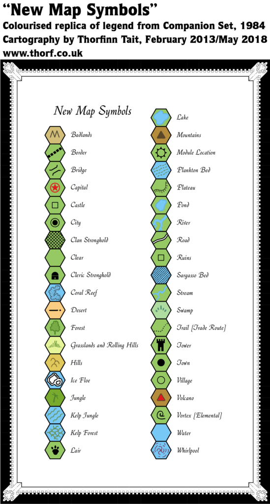
The Companion Set included an expanded legend with lots of new symbols, though for whatever reason almost none of them were ever used in published maps. The new icons are an eclectic mix: clan stronghold (a strange lattice effect covering the whole hex) and cleric stronghold, along with a less abstract tower; kelp, plankton and sargasso undersea icons; lair (an animal-looking paw print); whirlpool and vortex.
Hex Art & Fonts
- Fonts — Quill.
- New Symbols — many eclectic new symbols including Clan Stronghold (a diamond lattice), Cleric Stronghold (a domed building), Kelp Jungle and Kelp Forest (green wavy lines in parallel or in a lattice), Lair (an animal paw print), Plankton Bed (dotted green parallel wavy lines), Sargasso Bed (alternating line and dot pattern), Tower (tall building with battlements), Vortex (a wind-like swirl) and Whirlpool (spiral swirl with concentric wave patterns).
Analysis
Most of these symbols were not used in any official maps, and many have yet to be used even in fan-made maps.
Textual Additions (Companion Set 1984)
- Dominions — County of Garette. “You may place the County of Garette in any of your structured Dominions, changing any material as needed”. Additionally, three knights have names that may indicate dominions, or at least place names: Francoise de Gras, Sir John of Celtar, and Sir Guy de Gax. (DMs Companion, p. 59) The island of Garald the Blue is “a rocky isle off the coast of Vestland”, with a castle sitting “high upon a rocky promontory on the southern end of the island”. (p. 60)
- Military — troop numbers for Karameikos as follows: Black Eagle Guard (200), Men of Kelven (80), Ducal Guard (500), Western Elves (100), Eastern Elves (250), Thyatian Mercenaries (800), Gnomes (150), Orcs (300), Bugbears (80), Goblins East (300), Goblins Northeast (300), Lycanthropes/Were-creatures (100). (DMs Companion, p. 62)
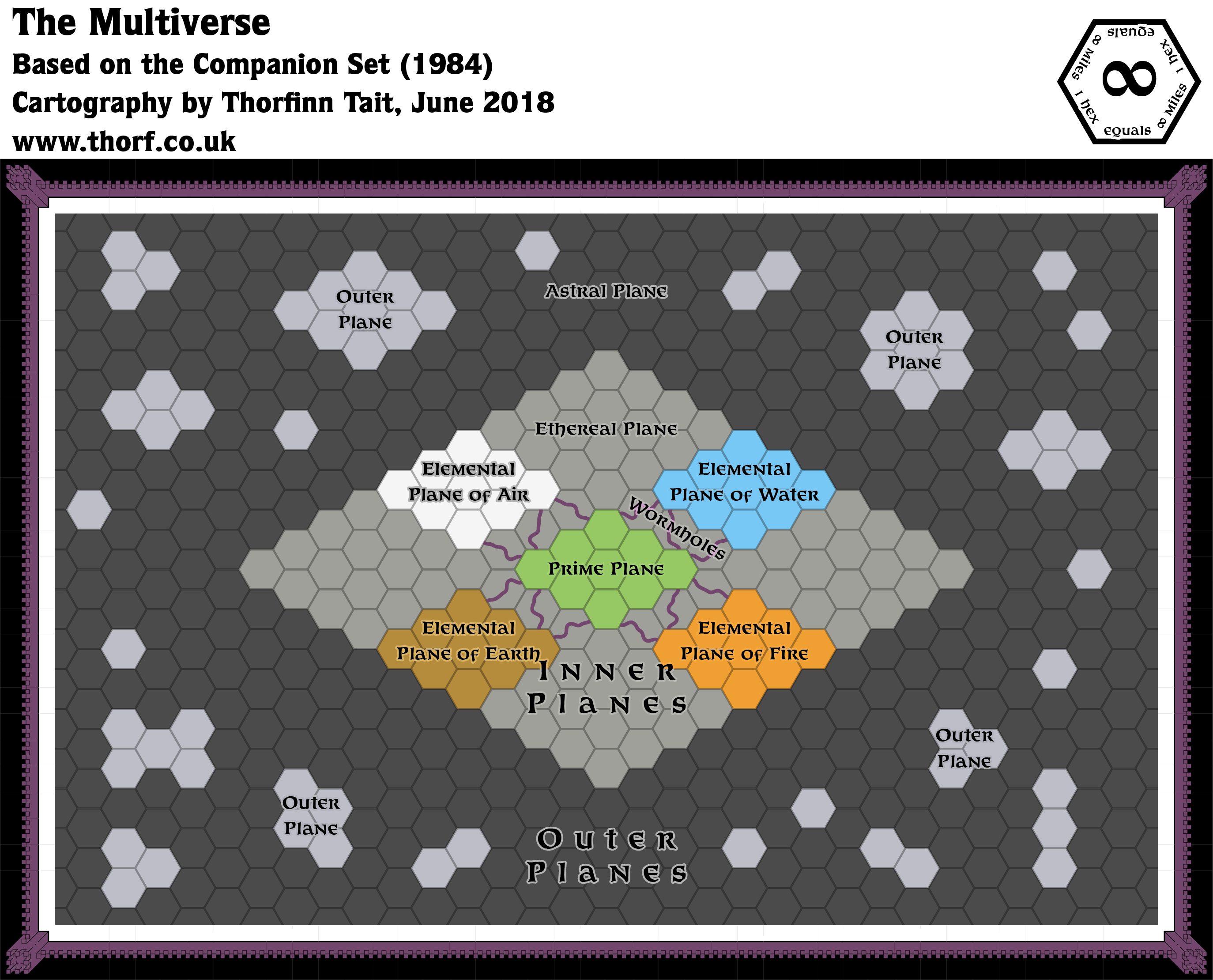
- Multiverse — the Multiverse is introduced for the first time. At this stage it consists of the Prime Plane, surrounded by the Ethereal Plane. Also within the Ethereal are the four Elemental Planes. The implication is that everything touches the Ethereal but not each other. All of this is known as the Inner Planes, and it is surrounded by the Astral Plane, which touches both the Ethereal and the Elemental Planes. Finally, the Outer Planes are in the Astral Plane. (p. 18 – 20)
- Planes — Prime Plane, Ethereal Plane, Elemental Planes of Air, Water, Fire and Earth, Astral Plane, Outer Planes. (p. 18 – 20) The Ethereal is noted as being filled with a grey fog-like material called ether, which condenses into sticky grey solid forms (ectoplasm). It’s parallel to the Prime Plane. The Elemental Planes are noted to consist of just their titular element, but in a form similar to the Prime, including planets and such. All four of the Elemental Planes have their own version of Mystara at their equivalent place, so that they all “overlap”. It’s also noted that some worlds lack one or more elemental equivalents, resulting in unbalanced worlds.
- Regions — Norwold is named here for the first time, referring readers to CM1 for more information. (DMs Companion, p. 64)
- Rivers — the river on which Specularum sits is called the River Highreach. Kelven (as it is spelled here) sits “at the intersection of 3 branches of the Highreach”. (DMs Companion, p. 61)
- Rulers — Count Sir James Essex is the ruler of the County of Garette. Other rulers listed: Sir Niles Count Douglass, Sir Mark Baron Acres. (DMs Companion, p. 59) Garald the Blue rules his pirate island. (p. 60) Stefan Karameikos is mentioned once again, this time as an Archduke. (p. 61)
- Scale — the scale of Expert Set (1983)’s Karameikos map (6 miles per hex) is noted here. (DMs Companion, p. 61)
Analysis
I’ve distilled the planar information into a symbolic map of the multiverse at this stage of Mystara’s development.
Map 22: “DM Map 1: World Area” from CM1 (June 1984)
From the Atlas of Mystara:
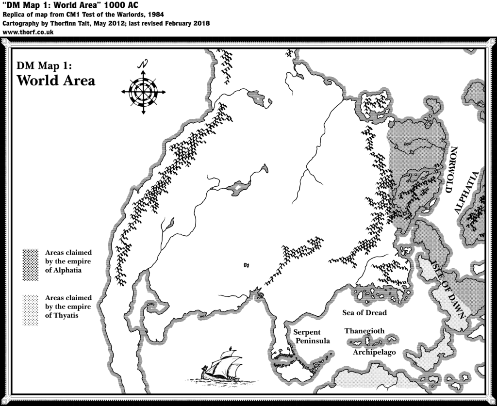
Before the world map was published in 1985’s Master Rules Set, this map of the continent of Brun appeared in CM1 Test of the Warlords (1984). An almost identical map was in the Companion Rules Set (1984).
This map shows most of the continent of Brun and the Isle of Dawn, along with hints of Alphatia and the much larger southern continent, Davania. It was the first small scale view of the world. While CM1’s map showed the extents of the warring empires of Thyatis and Alphatia, the Companion Set‘s map focused on showing where existing maps fit into the world.
The inspiration for this map is prehistorical maps of ancient Earth — Jurassic Earth, to be precise, around 150 million years ago. The map which this map was probably inspired from was featured in Continents in Collision (1983), a Time Life book in the Planet Earth series. Many fans spotted the similarities back in the 80s, though the map was not posted online until it was unearthed once again in February 2018. For the full story, see this article on thorfmaps.com.
Additions
- Borders — the rough border between the empires of Thyatis and Alphatia on the Isle of Dawn is discernible, as are the general areas of influence of each empire, although they don’t quite match up with contemporary maps. Alphatia is shown to claim all of Norwold except for the extreme northwest, Frosthaven, and the small isles north of the Isle of Dawn; the islands north of the Alphatian mainland; the Alphatian mainland, but not the spur to its southwest (likely an oversight); and of course half of the Isle of Dawn. Thyatis is shown to claim northern Davania, Ochalea and the western Pearl Islands (all still unnamed); half of the Isle of Dawn; and the Thyatian mainland, though the peninsula of Tel Akbir and some of the islands are not marked (likely an oversight).
- Nations — this map marks the first appearance of the Empire of Alphatia.
Hex Art & Fonts
- Fonts — Baskerville.
- New Symbols — None.
Analysis
CM1’s version of the Companion Set continental map matches it closely, to the point that they are variations of the same map. This one just adds a few labels and the extents of the empires.
Map 23: “DM Map 2: Norwold” from CM1 (June 1984)
From the Atlas of Mystara:
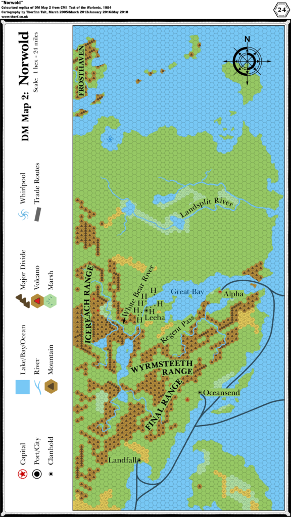
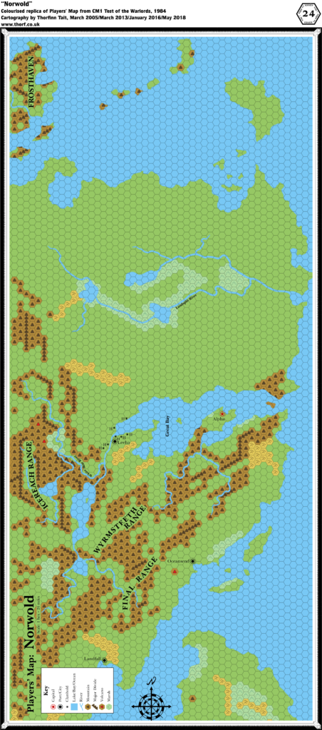
The region of Norwold made its debut in 1984’s CM1. Aside from the continental map showing its position in relation to the other established areas of the world at that point, there were two 24 mile per hex maps of Norwold: one for the DM, and one for the players.
While previous books such as X1 and X6 provided players’ maps, CM1’s players’ map is almost identical to the DM’s map. The only major difference is the lack of trade routes on the players’ map. The crop was also slightly different, with the DM’s map showing a sliver more terrain the north, east, and south.
The DM’s map was printed on a single page of the module, while the players’ map took up all three panels of the inside cover. Both replicas here use standard Atlas of Mystara hex sizes, which explains why the DM’s map’s labels look so huge — the original was printed at less than a third of the size of the replica.
Additions
- Borders — none are shown, although the continental map showed almost the whole area of the map as belonging to Alphatia, and presumably part of Norwold.
- Coastline — all of the coastline on the map appears for the first time at this scale.
- Islands — the northern tip of the Isle of Dawn; four islands north of the Isle of Dawn; islands of the Great Bay; islands of the far north, including Frosthaven.
- Lakes — six large lakes: three in the Icereach and Wyrmsteeth Ranges, and three along the Landsplit River.
- Mountains — three major mountain ranges: the Icereach Range in the west, the Final Range close to the coast, and the Wyrmsteeth Range in between.
- Mountain Passes — Regent Pass sounds like a mountain pass, although the label is not very clear.
- Nations — Norwold.
- Rivers — around fifteen major rivers and tributaries are added, although only two are named: the Landsplit River and the White Bear River.
- Seas — the Great Bay. Other seas remain nameless.
- Settlements — Landfall (a city), Oceansend (a city), Alpha (capital of Norwold), Leeha (a city), and seven clanholds around Leeha.
- Terrain — terrain other than mountains is rather sparse, with a few patches of hills and marsh but nothing else. Most of the terrain is left blank. There is a whirlpool marked in a bay southeast of Frosthaven.
- Trails & Roads — shipping trails are shown coming from the south and leading north via Landfall through Oceansend and on to Alpha in the Great Bay. Two routes lead off towards Alphatia in the east, one from the Great Bay, the other from south of Oceansend.
Hex Art & Fonts
- Fonts — Baskerville.
- New Symbols — Clanhold (a tiny city symbol), Major Divide (mountain symbols placed in a row, extending between hexes).
“Players’ Map: Norwold” from CM1 (June 1984)
Additions
- Terrain — a few hexes that were obscured on the DM’s Map are clear here.
Revisions
- Trails & Roads — the trails from the DM’s Map are missing here.
Hex Art & Fonts
- Fonts — Baskerville.
- New Symbols — None.
Analysis
This map is near identical to the DM’s Map. I’ll save analysis of the hex maps and their placement until after we’ve looked at the text.
Textual Additions (CM1 1984)
- Borders — Oceansend’s border can be extrapolated from the text: the city is surrounded by farms and small villages, most of which lie “within 50 miles or so of the city”. (p. 8) It therefore seems reasonable to consider its territory to expand two hexes from the city in all directions.
- Climate — “Norwold is a northern temperate region having four distinct seasons. Each of these seasons lasts approximately three months. Seasons in the southern part of Norwold are less severe than the seasons in the north. Precipitation is common in Norwold, and comes in the form of snow in winter, and rain in summer. During the spring and fall, the precipitation may come as either rain or snow (50% chance, modified plus or minus 30% based on the location of the specific region, and the time of the season-late spring, late fall, etc.). Some form of precipitation falls every four days. Of course, a thunderstorm or snowstorm may last much longer than one day. Also, a dry spell might last for weeks. Use the four-day figure as a rough average…” (p. 6)
- Dominions — the nature of CM1 is that various dominions, starting at a single 24 mile hex each, will be added to the map. However, exact locations are left to players and the DM to decide. Seven NPCs (see Rulers below) from CM1 are to be given dominions in Norwold. (p. 10-14) Alak Dool’s dominion apparently includes (or perhaps is composed primarily of?) humanoids, given the makeup of his military force. (p. 29) Finally six prerolled characters are provided for PCs, all of whom can also be considered dominion rulers. (Cover gatefold)
- Fauna — fire elementals near the Arch of Fire (p. 7); water elementals near the whirlpool (p. 8); frost giants in Frosthaven (p. 8); dragons in the Wyrmsteeth Range (p. 8).
- Forests — “A variety of terrain types covers the land of Norwold. Most of these types are shown on the players’ map. Consider unmarked hexes to be forest, as this is Norwold’s most common terrain type.” (p. 4) Also “Forests cover most of the land in Norwold.” (p. 6) So it seems that the blank hexes on the map are to be considered forest rather than plains — which makes sense if Norwold is largely an unsettled wilderness.
- “Trees grow in the lower mountain valleys as far north as the Great Bay. Mountainous areas north of the bay are barren of trees. NO trees grow at altitudes higher than 8,000 feet.” (p. 5) This presumably applies to the clear hexes surrounded by mountains, of which there are quite a lot on the map.
- “Dense forests cover most of the hilly areas in Norwold. Pines and other evergreens are the predominant forms of trees.” (p. 5) So most of the hills are forested with evergreens.
- “Evergreens are the only types of trees that grow in the northern forests, while broad stretches of oak, hickory, maple, elm, ash, fruit, and other hardwood trees mix with the evergreens in the southern forests.” (p. 6) There’s also a paragraph tackling the light versus heavy forest, noting that the DM should vary density to match the desired pace of the adventure. This is not very helpful from a mapping point of view.
- Meadows/prairies, some of which stretch 5-10 miles, as well as low hills may be included in any given forest hex. (p. 6)
- Government — Alphatia is a magiocracy. “The empire built its power on a solid foundation of magic. No fewer than 1,000 36th level magic-users make up this empire’s ruling council.” (p. 4) Thyatis “has developed upon a triad of powers. The theocratic, magical, and military elements of the empire all share the responsibilities of problem solving and policy development.” (Also p. 4) Norwold is a feudal monarchy. Leeha is a federation of halfling clanholds. (p. 8)
- Hills — “Where a mountain hex on the players’ map is adjacent to a clear hex, assume that half of the mountain hex is made up of ‘‘foothills’’- long, gradually rising ridges of rock that lead to the mountains.” (p. 5) This is difficult to mark at this scale, but worth remembering for larger scales such as 8 miles per hex. “Lakes and clear- ings dot the hills, and flowers and herbs are common in the thick meadows. Bogs and marshes fill some of the low spots on the hilly terrain.” (p. 5) This information could also be used to add some detail at a larger scale.
- Lakes — “As with rivers, only the major lakes are shown on the Norwold maps. Since so much of the land of Norwold is wooded and rainy, small lakes dot much of the land (at least one per hex in the south, as many as a dozen per hex in the north). All of the inland lakes are freshwater lakes. The mountain lakes are very deep, while the flatland lakes are shallow.”
- Marshes — “These areas are simply wet lowlands, and are unsuitable for development. No permanent structures could stand in these areas. There is a 20% chance, however, that a marsh hex contains small areas of higher ground large enough to hold a small village. … The nearby rivers and lakes flood the marsh areas each spring, covering all but the highest ground in 2-8 feet of water. The marshes freeze in winter”. (p. 5-6)
- Military — page 29 outlines the military forces of Norwold, as well as the Thyatian forces that attack during the adventure.
- Mountains — “The mountains of Norwold are towering pinnacles of rock that dwarf the summits of the renowned Altan Tepe Range, which lies far to the south.” “Many peaks in both ranges are snow-covered all year long. In the upper reaches of both ranges, huge glaciers sprawl outward. The ice in these areas has not melted for thousands of years.” (p. 5)
- “The Final Range runs parallel to the southeastern coast of Norwold. It is situated about 200 miles inland. The range took its name from ancient explorers who thought it represented the far edge of the world.” A number of peaks in the central regions of the Find Range reach 18,000 feet above sea level”. (p. 5)
- “The other range in Norwold is even greater than the Final Range. It runs north and south along the kingdom’s western border. Barbarians and savages refer to it as the Icereach Range or White Range, but the new govern- ment has not officially explored and named the range.” “…at least a dozen peaks in the Icereach tower over 24,000 feet high.” (p. 5)
- The Wyrmsteeth Range “lies to the northeast of the Final Range. No civilised beings live there, because it is the home of nearly 1,000 dragons. The range is named for the appearance of the peaks. If characters view the range from the horizon, they see that the main ridges look like the lower jaw of a drag- on’s mouth, and that the towering pinnacles of rock closely resemble a serpent’s drooling fangs.” The dragons live in numerous caves. (p. 8)
- Mountain Passes — page 7 confirms that Regent Pass is indeed a mountain pass: it’s the only gap through the mountains at the neck of Alpha’s peninsula. A garrison of 500 watches over the pass, stationed at a fortress. (p. 29)
- Nations — the Empire of Alphatia “has claimed the vast lands of Norwold, and has appointed a king to rule over those lands. This monarch is in need of steadfast characters to administer the many dominions that may be carved from the wilderness of Norwold”. (p. 2) “Norwold is little more than wilderness when the adventure begins”, though it has great potential for settlement, and “valuable natural resources”. (Also p. 2)
- As well as Norwold, this is the first mention of Alphatia. “Alphatia is the oldest empire in the world. It is located on a massive island off the eastern coast of Norwold.” (p. 4) Its true name is said to be “Atlantis”. (p. 27-28)
- Thyatis is given a little detail, too: “This empire is much younger than Alphatia. Actually, it is little more than a century old. The empire has spread rapidly outward from Thyatis, its capital city. It now encompasses several large islands off the southern coast of the continent.” “Many historians attribute Thyatis’ rapid growth to its leaders’ fabled capacity for greed and trickery. Although several of Thyatis’ territorial battles appear to have been fought on the field of honour, many more, historians agree, were won through treachery and deceit.” (p. 4)
- Placement — “Norwold lies to the north of the land shown on p. 33 of the D&D Expert rule book. To see how the Expert map relates to Norwold, line up the coastline near the bottom left corner of the map shown on this adventure’s inside booklet cover with the coastline at the top of the Expert map (near the Heldann Freeholds).” (p. 4)
- Resources — “Most mountain resources are mineral in nature. The most common mineral resources in hilly areas are tar, clay, coal, and stone. Besides the obvious wood and timber resources in forest areas, the main resources in these areas are animal or vegetable in nature. Tundra areas have only a 30% chance of holding a resource. A tundra hex never holds more than one resource, and that resource is never animal in nature.” (p. 6)
- Rivers — “Only the largest of Norwold’s many rivers are shown on the players’ map. Those rivers that are shown may be 1-4 miles wide at any given spot. For the most part, these rivers are too deep for wading. Assume that at least one river (50-200 feet wide) and several streams drain each hex on the map. Feel free to add to the waterways marked on the Norwold maps.” (p. 6)
- Ruins — Alinor was once a mighty port, but earthquakes and erosion caused it to sink below ground level. Now only a small part remains, in underground ruins accessible via a cave. The location within Norwold is not fixed. (p. 18-19)
- Rulers — King Ericall of Norwold (p. 4, 9) is the second son of Eriadna the Wise, current Empress of Alphatia. (p. 4) Thincol the Brave is the current Emperor of Thyatis. (p. 4) Lernal the Swill is Ericall’s younger “demented half-brother”, lord of Landfall. (p. 7, 9) King Yarrvik the Just is ruler of the free city of Oceansend. (p. 7, 9) Norwold dominion rulers: Alak Dool, Sir Ernest Day, Rutger Dag from Vestland, Sandralene of Glantri, Max the First, Allisa Patrician from the Ethengar Khanate, Longtooth. (p. 10-11) Also prerolled PCs: Fergus the Justifier from Vestland, Geoffrey of Heldann, Weston the Tall, Quillan Elm-Grower from Alfheim, Brogahn of the Steppes from Ethengar, and Claransa the Seer from Karameikos. (Cover gatefold) Gard Rocktooth is Clanmaster of the dwarven stronghold of Stormhaven. (p. 22) Collin the Sheriff leads Leeha’s military force, and is presumably one of the seven sheriffs of Leeha’s halfling clanholds. (p. 29)
- Seas — during winter “ice connects Frosthaven to the shores of northern Norwold”. (p. 8) In particularly extreme winters the Great Bay itself may freeze over. (p. 16)
- Settlements — “The only civilised areas in Norwold when the adventure begins are Alpha and the five hexes that surround that city; the demi-human strongholds; Landfall; Oceansend, and the coastal hexes on each side of that port city.” (p. 6)
- Alpha (p. 6-7), population 30,000, with more than 60,000 living and working in the civilised regions nearby. Has “a splendid deep-water port”. Bustling waterfront. Connected by trade route with Alphatia as well as the rest of Norwold. Large fishing industry. Farms surrounding Alpha are very prosperous, and are populated by natives who “have welcomed the arrival of King Ericall and are happy to be members of an established form of government”. Built “on the ruins of an ancient fortress, utilising some of the old fortifications”. Heavily fortified city. Fortress has direct harbour access, room for 10,000 people to shelter. King’s palace “stands on a hill in the centre of the fortified zone”.
- Landfall (p. 7), population 10,000, “little more than a collection of squalid huts and sleazy dives”. “The dirty, ramshackle docks of Landfall mar the shore of a once placid bay.” “Lernal lives in a large, poorly built wood mansion, and the rest of the city is devoid of any stone buildings or fortresses.” “Poor farms are scattered throughout the land that surrounds the city.”
- Oceansend (p. 7), population 20,000 (of which 3,000 are dwarves, 2,000 halflings, 500 elves), a “heavily fortified community” with another 20,000 people living in the countryside that surrounds Oceansend — most “on prosperous farms or in small villages within 50 miles or so of the city”. A free city, not yet aligned with Alpha and the Kingdom of Norwold. A “thriving, vibrant city that is much older than either Alpha or Landfall”. (p. 8)
- Small dwarven communities near some branches of the Final Range mountains west of Oceansend. These dwarves trade metal items with Oceansend for produce and imported goods, and they have a staunch alliance. (p. 7)
- Leeha and the seven halfling clanholds (p. 8). Population is 700-1,200 in each clanhold, total 6,500. Leeha is “the clans’ central gathering place” on the White Bear River. The halflings have “excavated huge warrens along the riverbank, so that the members of all the clans may stay in Leeha”. From this description, the permanent population of Leeha is uncertain.
- “Several dozen” Foresthomes (elven communities) “thrive in the forests or Norwold”. The exact locations are left up to the DM. “Each of the communities is home to 200-1,200 elves.” “Most of the elven communities exist in areas where the trees are a mixture of evergreens and hardwoods.” This suggests that the elves may be mostly in the southern forests, as the northern forests are said to be mostly evergreen. “The few meandering paths the elves leave on the ground are almost unnoticeable. A Tree of Life stands at the centre of each of these communities. The elven agriculture consists mainly of a few small gardens.” (p. 8) Another piece of evidence for Foresthome locations: when Frosthaven giants enter Norwold and head for Leeha and the mouth of the Great Bay, “several elven communities lie in the giants’ paths” (p. 16). The implication is that there are indeed Foresthomes north of the Great Bay.
- Stormhaven is a dwarven stronghold, “a network of caves located high in a rugged mountain range”. Population 2,500. Stormhaven’s location is left up to the DM, who is instructed to place it in a mountain hex near the characters’ dominions. (p. 22) Given that PC dominions could be almost anywhere, it seems that Stormhaven could also be anywhere that dominions could be placed nearby.
- Crystykk is a mountain cave, inhabited by the three crones. (p. 24-27) The location is not fixed: “in a dark region of rocky peaks, far from any civilised lands” and “somewhere in the uncivilised lands of Norwold”.
- The Regent Pass fortress guards the mountain pass, with a garrison of 500. (p. 7, 29)
- Terrain — Frosthaven is “a barren island of ice and rocks”. “Because the island lies so far north, no plants other than mosses and fungi grow on the island. Icy winds and blizzards sweep Frosthaven three seasons of the year.” A “huge clan” of frost giants lives here in “a number of huge caverns, which are carved into the ice of the living glaciers. A complicated series of ice tunnels connects most of these caves. Some 6,000 frost giants live on the island; 2,000 of them are warlike males.” (p. 8) The marsh near Oceansend is referred to as the Oceansend Marshes (p. 28) In addition Norwold has two special features:
- the Arch of Fire is an arc of elemental fire between two volcanoes near the Icereach Range. “They stand 75 miles apart.” “The arch of fire is visible up to 72 miles away (3 hexes) at night, and up to 48 miles away by day. The arch reaches a height of 6 miles in its centre, and forms a tube roughly 300 feet in diameter.” “The hexes containing the two volcanoes are true wastelands of fire. The land that surrounds each of the volcanoes is relatively flat, and is crisscrossed by flowing rivers of lava. Huge lakes of fire lie at the bases of the volcanoes. Many small cave mouths dot the rocks that surround the mountains. Although most of these openings lead nowhere, some do connect to fissures deep within the earth. Rushing gouts of steam occasionally scald these caves. Fire giants, red dragons,” and fire elementals inhabit these caves, which also include wormholes to the plane of fire. (p. 7)
- the giant whirlpool in the bay south of Frosthaven is actually a vortex leading to the elemental plane of water. (p. 7-8)
- Trade Routes — “Well-traveled trade routes lead west from Oceansend to some branches of the Final Range”.
- Tundra — “This flat, wet land exists only at the extreme northern end of Norwold.” (p. 6) The question is, how much of Norwold does “extreme north” include? We don’t have latitudes for reference yet at this point, so comparison with the real world, in which tundra generally falls north of 60 or 70º latitude, can’t help us yet. Since the word “extreme” was used, I’m just going to consider the northernmost two or three rows of hexes to be tundra for now. Page 6 goes on to provide a nice definition of tundra: “The tundra is a region of terrifyingly severe winters and soggy, muddy summers. Herds of grazing animals cross the tundra during the pleasant months, stalked by an occasional predator. All but the cold-loving creatures abandon the tundra in winter, however. During the summer, 10-40% (1d4x10) of a tundra hex is covered by ponds, and wide, shallow lakes. Fish are not common in these bodies of water, but huge swarms of insects usually are.”
Analysis
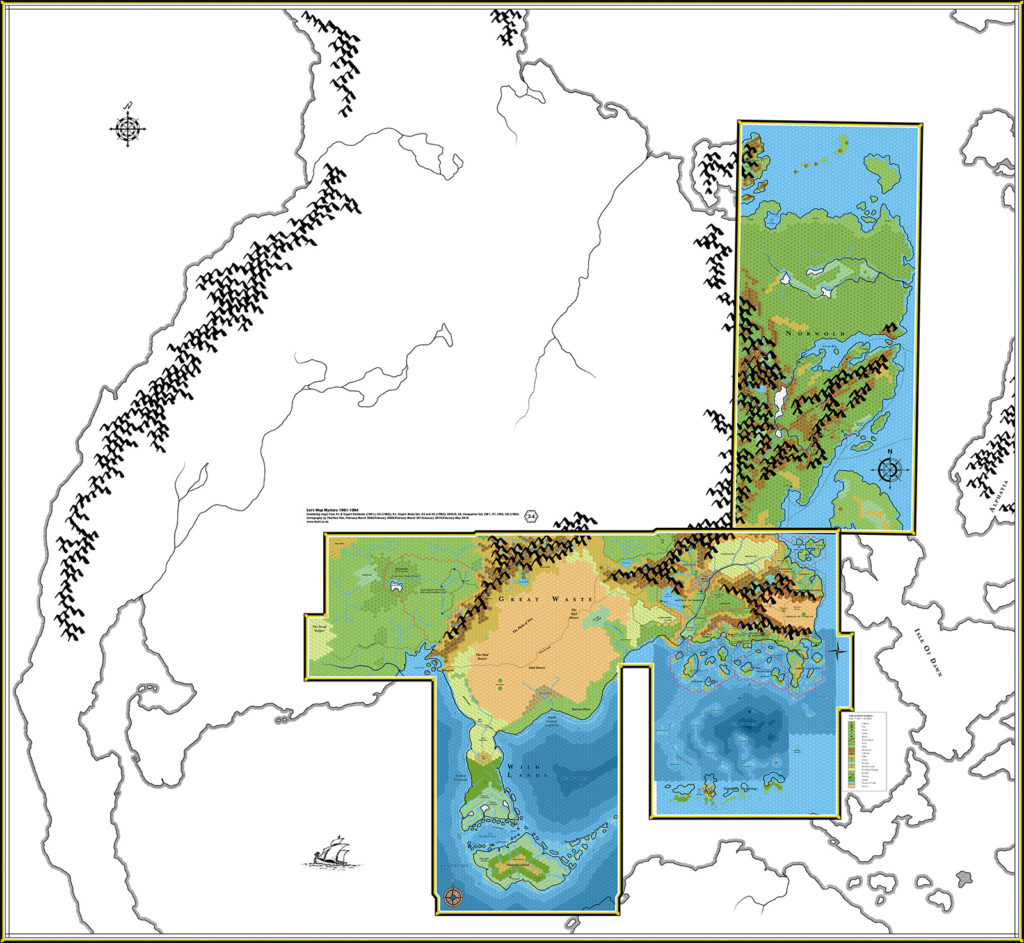
Adding the hex maps to the compiled maps up to this point is rather problematic. It’s easy enough to do as the text suggests and simply place the two maps together, but the resulting placement doesn’t fit with the continental map at all.
The solution may seem rather drastic, but it works quite well: place the map so that the coastline roughly lines up, as the text suggests, then rotate the whole Norwold map 1º clockwise. With a little nudging, this fits rather well with the continental map.
The obvious downside to this solution is that the hex grid no longer lines up perfectly with other areas, since it has been rotated. However, this is only really a problem when considering maps covering the join between Norwold and neighbouring region. This issue can be fixed by producing a new map with the hex grid rotated back to the usual position, while keeping the terrain, coastlines, etc. in their rotated position. Such a map will look slightly different from the original Norwold maps, but both maps will be equally valid and compatible with each other.
So why do this? The main reason is that it preserves the integrity of the continental map as well as the hex maps. This is a major issue, because the CM1 and Companion Set maps of Brun are the best sources for much of the continent; maintaining the integrity of these maps is therefore a very desirable thing.
My previous attempt at tackling this problem, in 2016’s Lining Up Mystara project, resulted in cutting up the Brun map and placing the pieces back together as best I could. It worked, though it involved a lot of arbitrary decisions. But this new placement provides the possibility of preserving the integrity of both the Brun map and the hex maps, allowing us to take the Brun map at face value.
Another point to note is that some of 1985’s maps also require some rotation to fit them to the continental map, so it does make sense to use this solution here. But I’m getting ahead of myself.
There’s a lot of information in CM1, and indeed it has taken me a long time to get through all of the text. Unfortunately a lot of it is very hard to add to the map; to compensate for this, I have taken extensive notes for future reference.
Major things that were mentioned in the text but not added to the map for lack of even a vague official location include: dwarven communities near Oceansend; dwarven stronghold Stormhaven; several dozen elven Foresthomes; seven NPC dominions and six prerolled PC dominions (all of which have named rulers but no dominion names); Crystykk; caves for dragons in the Wyrmsteeth Range; caves for frost giants in Frosthaven; and other things besides.
There are also various terrain types that have not been added yet for lack of appropriate hex art. I have noted many of these on the map — most notably tundra and glaciers.
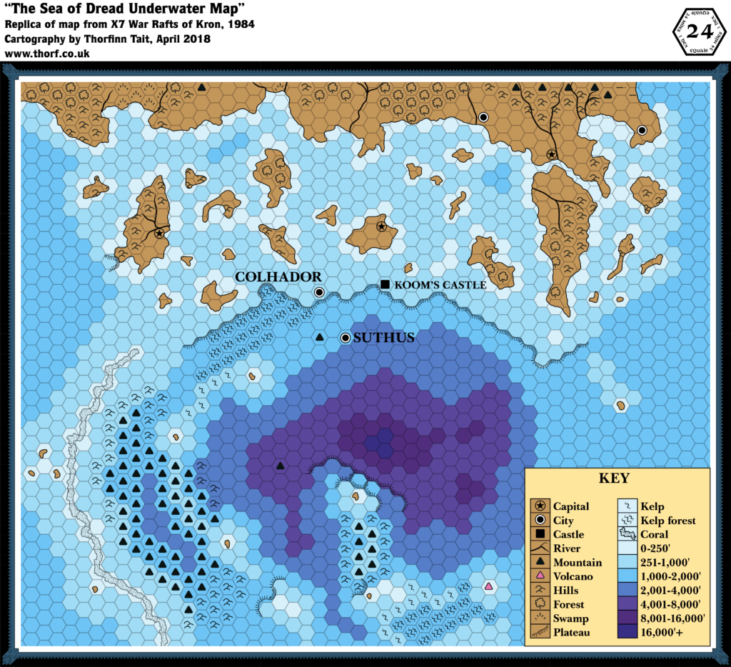
Map 24: “Sea of Dread Underwater Map” from X7 (September 1984)
From the Atlas of Mystara:
Not content with the massive land expansion of 1984 in previous modules from X4 to X6, X7 instead expanded into the ocean itself, providing a wonderful view of the land beneath the waves of the Sea of Dread.
Depths were not marked on maps again for another few years, and this map remains one of the two best sources for the undersea layout of the region, the other being 1990’s PC3.
Additions
- Depths — contour lines and depths for much of the Sea of Dread, with precise numbers assigned to each depth line. This is the second map to give ocean depths (the first being X6), and the first for this area.
- Reefs — the Dragon’s Teeth Reefs detailed in XSOLO’s text appear here for the first time. How far the reefs extend south is not entirely clear from this map, though XSOLO’s text is a useful reference for this.
- Settlements — Colhador (city), Suthus (city), Koom’s Castle.
- Underwater Terrain — kelp and kelp forests as well as undersea mountains and hills. A single volcano is marked, though it’s not clear if this is underwater or a volcanic island above sea level. The depth around the mountain suggests that it is at least close to the surface, since the hex it’s in is 0-250′ deep.
Revisions
- Coastline — almost the same as previous maps of the area; it’s clearly traced from those maps.
- Islands — the islands here correspond to both X1’s as well as XSOLO’s islands, with the same general locations and shapes.
Hex Art & Fonts
- Fonts — Baskerville. Map title (not shown here) is Bernhard Modern.
- New Symbols — Kelp (a single diagonal squiggle), Kelp forest (three diagonal squiggles — like Kelp Jungle from Companion Set but mirrored), Coral (dotted texture within a solid black line). Underwater Mountain and Hills are also used here for the first time, though the symbols are identical to overland versions.
Textual Additions (X7 1984)
- Government — there are some insights into the government of the Minrothad Guilds: “The isle of Minrothad is divided into many small baronies. The baronies form trading guilds, each having its own plot of land. The family-owned guilds have much vicious political dissension among them. The city of Minrothad is neutral territory where the guilds can meet and trade.” There are also hints of xenophobia: “The merchants of Minrothad will not sell magical items to foreigners.” (p. 4)
- Islands — “The guild’s masters offer you a small island (six square miles) next to Minrothad if you can rescue the princess and discover who is pirating their ships.” (p. 4) This island is far too small to appear on 24 mile per hex maps; most of the small islands of the Sea of Dread are around 60 square miles, so this isle would be a tenth of their size — a mere speck at this scale.
- Nations — official titles for the nations in X7 are: the “city-state of Suthus” and the “Grand Hydrate of Kron”. (p. 10)
- Races — Koom’s Castle is inhabited by a lone storm giant. Suthus is inhabited by tritons. Colhador is largely ruined, and essentially a dungeon now. Kron’s inhabitants are human.
- Rulers — Lopra is the triton king of Suthus. (p. 7) One-Eye is the pirate ruler of Kron. (p. 7) Hadric of Colhador, now a velya, was a prince of that ancient city before it sunk to the sea-floor. (p. 7, 26, 28) The ruler of ancient Colhador was King Hador, son of Gorlab. (p. 28)
- Settlements — there are four settlements, including the three marked on the map and the titular raft city:
- Koom’s Castle is the underwater home of the storm giant, Koom. It is located right at the edge of an underwater cliff. (p. 5-6)
- The raft city of Kron “floats upon the sea, its position is ever-changing”, according to Koom the storm giant. (p. 6) Koom further states that Kron is two days’ sailing south of Koom’s Castle, after which its exact position can be found by befriending dolphins, which can find the city. (p. 6) Kron is a city of pirates, whose existence is made possible by an artefact: the Horn of the Sea God (p. 4), a throne shaped “after the hand of a sea god”, which prevents anything attached to it from sinking. (p. 13) Population of Kron is unclear.
- The “sunken city” of Colhador (p. 6), like Koom’s Castle, is on the edge of the undersea cliff. It “was one populated by airbreathing people. A catastrophe many centuries ago caused it to sink to the ocean floor. Among the tritons there are rumours of other cities of the same people, now lying on the ocean floor.” (p. 19) So it seems that Colhador is just one of many ruins in this area, and in fact this area was land hundreds of years ago.
- Suthus, “city of the tritons” (p. 7) or “citadel of the tritons” (p. 6), is a “city made entirely from dead coral cut from distant reefs”. (p. 7) The population is unclear, though it seems to be wholly composed of tritons.
- Shipwreck — the text gives a shipwreck encounter to be discovered “at any point in the adventure”. (p. 6) Given this and the nature of the adventure (pirates sinking trading ships), it seems safe to assume that the Sea of Dread is littered with shipwrecks.
Analysis
The text of X7 doesn’t provide all that much that can be added to the map. I’d like to be able to place Kron, with arrows showing its approximate course. But there’s not really enough information to do this. For now, it has been placed seven hexes south of Koom’s Castle.
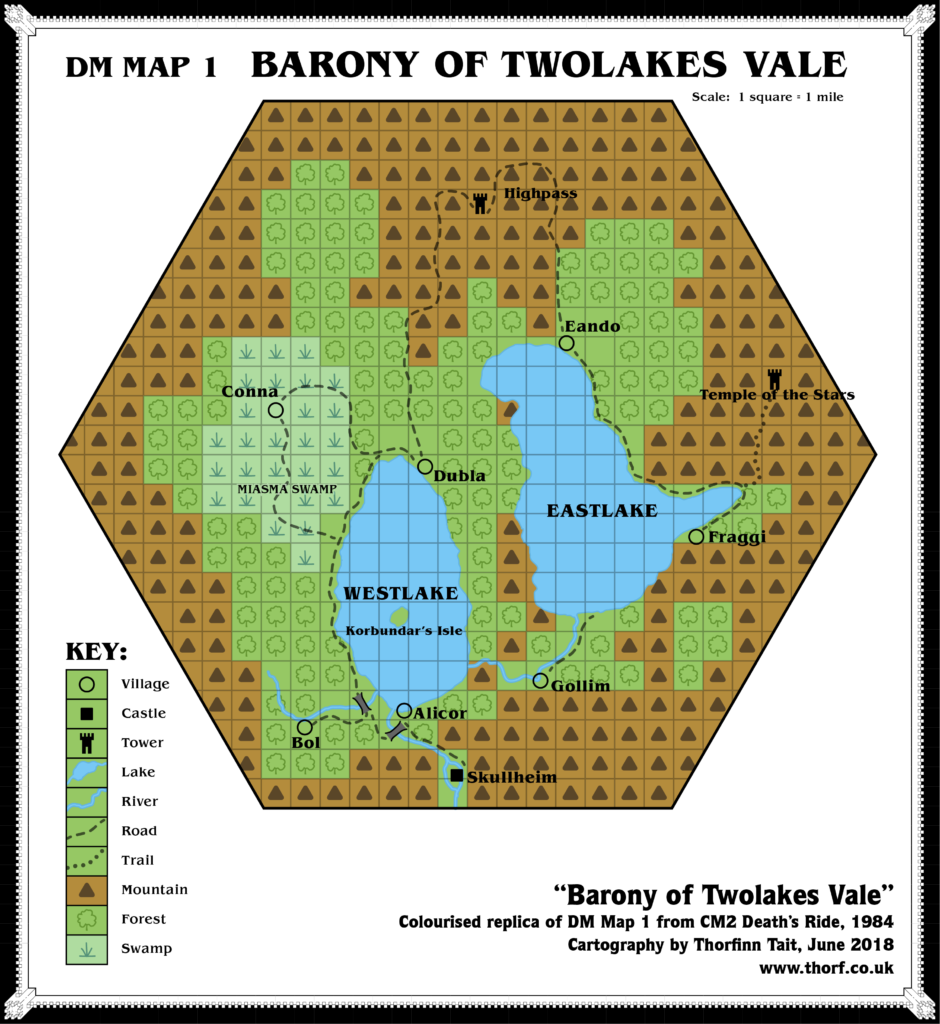
Map 25: “DM Map 1 Barony of Twolakes Vale” from CM2 (October 1984)
From the Atlas of Mystara:
After CM1, much of the Companion module series continued to focus on Norwold. CM2 added the Barony of Twolakes Vale, a single 24 mile hex on CM1’s Norwold map. The exact location in Norwold was left up to the DM; fans have proposed a number of likely locations.
The map itself is rather unique among Mystara maps in that even though it details a hex-shaped area, the actual map is divided into a grid of squares. One glance at the colourised replica here quickly reveals the problem with this: whereas hexes give at least an impression of disorder and natural shapes, squares look decidedly digital. The original map was black and white, and the problem wasn’t so obvious there, though it still looked a bit too regimented.
Additions
- Borders — the barony’s borders appear to be the 24 mile hex.
- Bridges — two bridges over the rivers in the southwest.
- Dominions — the Barony of Twolakes Vale.
- Islands — Kobundar’s Lair is on a lone island in Westlake.
- Lakes — Westlake and Eastlake.
- Mountains — the vale is rings by mountains, although none are named.
- Mountain Passes — Highpass appears to sit on a mountain pass.
- Rivers — a number of rivers, all unnamed.
- Settlements — Skullheim (castle), Alicor (village), Bol (village), Conna (village), Dubla (village), Eando (village), Fraggi (village), Gollim (village), Highpass (tower), Temple of the Stars (tower).
- Terrain — the Miasma Swamp surrounds the village of Conna.
- Trails & Roads — a network of roads weaves its way through the vale, connecting most of the villages. A trail up into the mountains leads to the Temple of the Stars.
Hex Art & Fonts
- Fonts — Benguiat.
- New Symbols — None, although this is the first use of the Tower symbol on a map; it previously appeared only in the Companion Set legend.
Analysis
It would appear that the barony would fit in any hill or mountain hex on the Norwold map — even one in the middle of a mountain range.
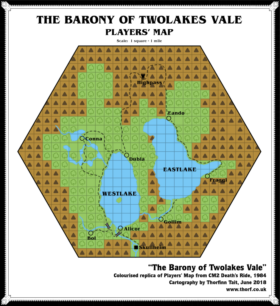
“Players’ Map: The Barony of Twolakes Vale” from CM2 (October 1984)
Revisions
- Lakes — eight small lakes around the village of Conna in the west, where the DM’s map had the Miasma Swamp.
Analysis
This players’ map shows the state of the barony before the events of CM2 occur. The only difference of note is the western region around Conna.
Textual Additions (CM2 1984)
- Dominions — the Barony of Twolakes Vale is described as “a distant mountain dominion”. (p. 3) The dominion is extensively detailed in the text. (p. 5-7)
- Island — Korbundar’s island is “roughly 350 ft. square”. (p. 13) This is much, much smaller than the large island shown on the map. DM Map 4 shows the island in detail, and this could be used to update the main map.
- Rivers — there are dangerous, unnavigable rapids between Skullheim and Alicor. (p. 12)
- Rulers — Baron Sir Maltus Fharo rules Twolakes Vale. (p. 3)
- Settlements — Skullheim, population 25 families (125 people), is the village in which Skullheim Castle is located. The castle’s population is uncertain, but likely a few hundred at the very most. “The castle sits on an island bordered by the river that flows southward from Westlake. The island is literally only a few yards wider than the castle’s outer walls; the river flows in a raging torrent along the castle’s west wall.” (p. 4, 5, 8) Alicor, a fishing/farming village, population 100 families (500 people). (p. 5) Bol, a logging/farming village, population 25 families (125 people). (p. 5) Conna, a gourmet/fishing/farming village, population 25 families (125 people). (p. 5) Dubla, a fishing/farming village, population 50 families (250 people). (p. 5) Eando, a fishing/farming village, population 50 families (250 people). (p. 5) Fraggi, a fishing/farming (some logging) village, population 75 families (375 people). (p. 5) Gollim is a lead mining/farming village, population 150 families (750 people). It is “nestled in the hills southwest of Eastlake”. (p. 4, 5, 23) Korbundar’s Lair is located on Korbundar’s Isle. (p. 4)
- Terrain — Twolakes Vale appears to be split into two valleys. Despite the apparent connection in the centre of the map, the module states that “the best way to get to Eando, Fraggi, and Gollim is by the Highpass road; the terrain off-road is very rugged and dangerous, and has been getting worse”. (p. 12)
- Trails & Roads — the Westlake Road. (p. 4) “Blocks of yellow clay pave parts of this road as it leads north from Skullheim into the barony.” (p. 12) A “major trade route” leads into Twolakes Vale from the south, terminating at Skullheim. (p. 8)
Analysis
There are a few details here to improve the map of Twolakes Vale, but only a few hints to resolve the problem of where to place the barony in Norwold. “Distant” presumably means distant from Alpha, and possibly somewhere inland. Northwest of the Great Bay might be a good choice.
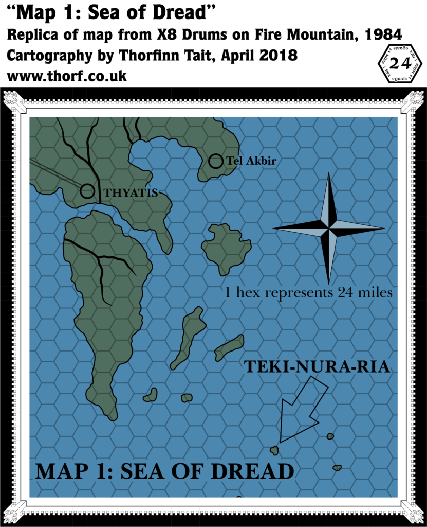
Map 26: “Map 1: Sea of Dread” from X8 (October 1984)
From the Atlas of Mystara:
A small footnote in 1984’s massive expansion of the mapped world of Mystara, X8 nevertheless provides one unique addition to the map: the island of Teki-Nura-Ria and three other small islands in the Sea of Dread a couple of hundred miles from the coasts of Thyatis.
Additions
- Islands — Teki-nura-ria and three neighbouring islands, the southernmost of which is only just shown on the edge of the map.
Hex Art & Fonts
- Fonts — Baskerville.
- New Symbols — Compass Rose (simple cross with shading).
Analysis
The coastline of Thyatis does not fit the hex grid in the same way that X8’s map did. As a result, the grid is no help in establishing the precise placement of the map; instead, I have lined up the coastline of Thyatis, and obtained the best relative placement of Teki-nura-ria this way.
It’s worth noting that this is not a technique I have used often, as usually it’s preferable to line up the hex grid and ignore minor coastline misalignments, both for ease of placement as well as (crucially) maintaining compatibility between maps. However, in this particular case no other maps are affected by this change, so it seems the best choice.
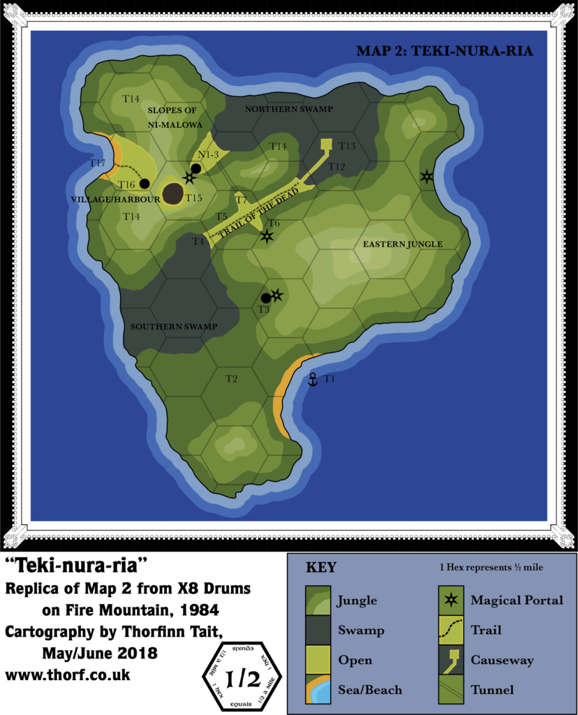
Map 27: “Map 2: Teki-Nura-Ria” from X8 (October 1984)
From the Atlas of Mystara:
X8 detailed the island of Teki-nura-ria quite thoroughly. In addition to this overland hex map, printed with an enlarged hex grid, there are dungeon maps covering the extensive network of tunnels and chambers beneath the island.
Additions
- Coastline — detailed coastline for the island.
- Mountains — Ni-malowa is the western volcano, the slopes of which are marked on the map. The eastern peak is unnamed here.
- Settlements — three unnamed village icons are marked.
- Terrain — Northern and Southern Swamps, Slopes of Ni-malowa, Eastern Jungle.
- Trails & Roads — the Trail of the Dead.
Hex Art & Fonts
- Fonts — Baskerville.
- New Symbols — Magical Portal (six pointed star with circular hole in the middle, like a shuriken), Tunnel (two parallel dotted lines).
Analysis
The shape and size of the island is slightly different from the 24 mile per hex map, and can easily be used to update that map.
Map 28: “Sketch-map” from X8 (October 1984)
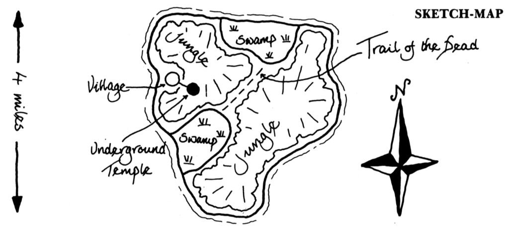
Nothing much to note here.
Textual Additions (X8 1984)
- Fauna — tarantella (p. 6); rock python (p. 7), topi, hydra.
- Island — Teki-nura-ria means “mountain of death” in the kara-kara language. (p. 2) There are three kara-kara who live “on another kara-kara island” in the prison pits, suggesting that perhaps the kara-kara inhabit some of the other nearby islands on the map. (p. 12)
- Mountains — the eastern volcano is named Ki-ata in the text.
- Ruins — the village marked at T3 on the map is in fact ruined.
- Rulers — KalnaKaa is the ruler of the kara-kara.
- Settlements — the Kara-kara Village, population 370 kara-kara (180 plus another 190 warriors from the caves). (p. 8)
- Terrain — as depicted on the map, “Nearly the whole of Teki-nura-ria is covered by dense vegetation.” (p. 4) Both swamps are overgrown with trees and mangroves. (p. 6-7)
Analysis
Most info here is useful only to slightly update the large scale map, and as such is somewhat outside the scope of this project, in the same way as the dungeon maps.
The Maps So Far: 1984
That brings us to the end of 1984. It’s been quite a journey. To sum it up, we have:
- added the Wild Lands and the Serpent Peninsula to the south, as well as Norwold to the northeast
- added deep water to two areas of the map, while refining and naming the isles of the Sea of Dread
- detailed another couple of areas close up
- expanded the scope of the map to encompass the whole continent, with parts of the Isle of Dawn, Alphatia, Ochalea, and even Davania on the edges
- and we’ve even started mapping the multiverse itself.
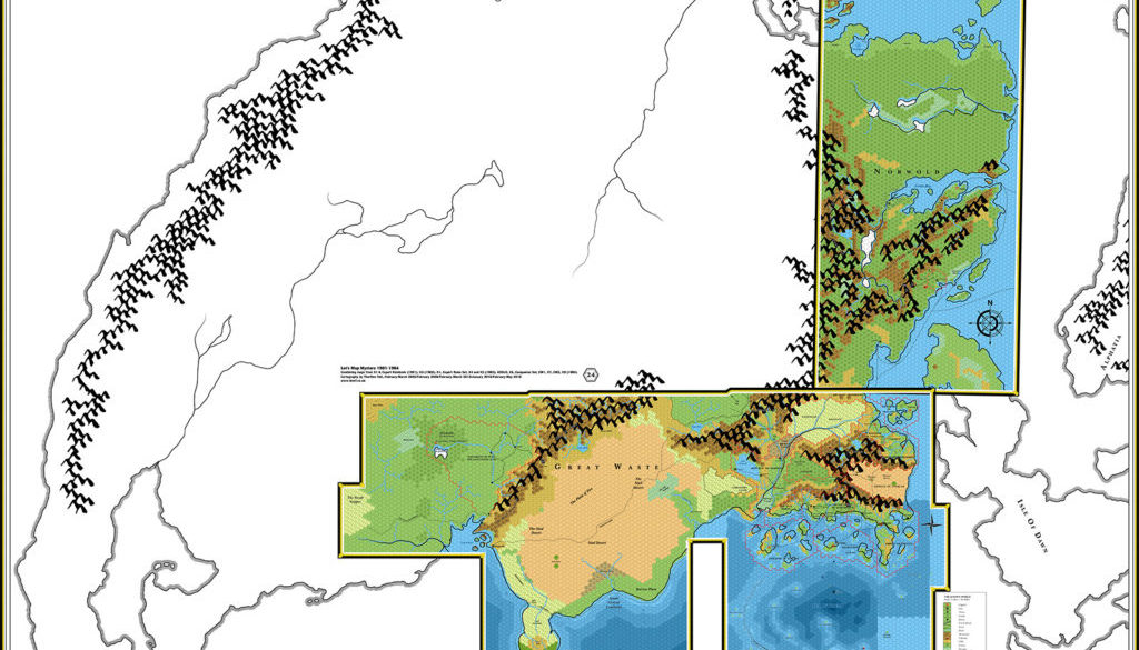
Head on over to the Atlas of Mystara web site, where the 1984 maps have a permanent home. Note that the 24 mile per hex map is now so big that I’ve had to shrink it to one third size to fit it in here. You can get the full resolution file here (right click and “save linked file” if you can). You can also get the full resolution of the variant with the Brun coastlines and mountains overlaid by clicking here.
The Mystara 1984 maps have a permanent home at the Atlas of Mystara web site.
8 November 2018 @ 4:40 am
I do hope that the lack of followup posts isn’t a sign that this project has ended. I really love what you are doing here and I can’t wait until you make it to some of the later products. I’m really interested in seeing how some of the MUCH later AD&D Mystara products fall in line with previously published material. Also, I really like how you keep pinning everything together on a larger map as you go along. It really helps in envisioning how it all fits together.
Please keep going!!!
8 November 2018 @ 8:57 am
Hi Chris!
Thank you very much for this message — it really means a lot to hear this sort of thing.
As it happens, I’ve been back working on this project for a couple of months now. 1985 includes quite a few problematic maps, as well as many maps that I haven’t yet made replicas of (O2, CM5, and some in M1 too). So it’s taking a while to work through it all.
It might be a few months yet before I can publish the full article for 1985. I’ve still got a long way to go, but I’m making good progress, with the Master Set world map largely done.
By the way, I’m also working to archive the yearly map collections on the Atlas site (in the new Appendix C section), as well as incorporating the lists from this project into the Atlas’s map articles — 1981’s maps are already done.
18 March 2019 @ 6:43 am
I would like to second Chris’s sentiments above – it would be a shame if this project has come to a close.
Assuming that this project is still ongoing – given the amount of D&D material that was published in 1985, might it be an idea to split the next post up into part 1, part 2 etc and post each part separately? That might help to make the whole thing more manageable.
19 March 2019 @ 9:25 am
Don’t worry, I’m not going to abandon this project. It’s still ongoing.
I’m still making progress, albeit slowly. Splitting up the posts is an idea — I started out that way, after all — but I’m not sure it’s viable in 1985’s case, since much of the stuff remaining to be done is from early on in the year.
But thanks for your concern and support. I will get there.
2 April 2019 @ 2:41 pm
I’ll echo the above two sentiments that your work is amazing and appreciated. I can’t wait to see the Master Set’s world map!
3 April 2019 @ 8:41 am
Thanks! I’ve made great progress on 1985 recently. There’s just one map left to finish, and the notes on maps are almost done too. After that all that remains is to finish polishing up the new set of maps, and the article will be good to go.
CM1 Norwold, 24 miles per hex | Atlas of Mystara
17 April 2019 @ 10:20 am
[…] This is Map 23. It was published in June 1984. The updated version of this map has not yet been released. See also Appendix C for annual chronological snapshots of the area. For the full context of this map in Mystara’s publication history, see Let’s Map Mystara 1984. […]
26 September 2020 @ 12:36 am
Hi Thorf! Perhaps I’m a bit late on this, but have you considered adding to your wonderful summary map the village of Sarsdell and the Ghost of Lion Castle of BSOLO module? The adventure was issued in 1984. On pages 7 and 8 there are a few notes that may help in placing the village and the castle. Here are some relevant quotes:
(1) “Sargon was a strong wizard indeed, son, and his castle is a sight to behold. He built it on the grassland plains in the land they now call the Ethengar Khanate”
(2) “Follow the Streel River east for six days, and then hike north for two. After eight days, you should be able to see that great stone lion rising from the plain”
(3) “You cross the river by ferry and turn east to walk along the river. The great grassland of the Ethengar Khanate stretches out ahead of you.”
Given that – from (3) – as soon as you leave Sarsdell and cross the river you face the steppes, I’d say that Sarsdell is located in the north-eastern Broken Lands, I’d say in the hex bordering the steppes crossed by two rivers and positioned west of the Streel at the very edge of the Ethengar Khanates. Assuming the Expert Set standard movement rate on foot in unhindered terrain of 18 miles/day then the Lion’s Castle is 108 miles east along the Streel River + 36 miles north from this point.
If I did my calculations right then the Lions’ Castle should be located in the hex directly under the “A” of “Ethengar” in the Expert Set map.
On another matter, a village named Farstead is the home town for BECMI adventure “The Sword of Justice” in Dragon Magazine #92 (December, 1984). The compatibility with the village of Farstead from PC1 adventure “The Lost Seneschal” was already pointed out in this old thread at the Piazza: http://www.thepiazza.org.uk/bb/viewtopic.php?t=3395
In PC1 adventure Farstead is located (page 18 of the adventures’ booklet) “somewhere in the Republic of Darokin, in a forested area (perhaps by the Dreamlands)”.
Perhaps someone at TSR writing PC1 adventure hooks remembered the old location from Dragon Magazine #92 and added it to the setting. It could be worth placing Farstead in the 1984 map as a reference for the “The Sword of Justice” adventure.
Hope these help!
😉
Thibault’s Mystara, 72 miles / hex 1998 | Atlas of Mystara
18 July 2021 @ 9:00 pm
[…] needed to connect these areas have now been documented in the Let’s Map Mystara project (1984 for Norwold, 1985 for the Savage Coast), but in 1998 there was no way for even the most dedicated […]
Karameikos, 6 miles per hex (1984) | Atlas of Mystara
7 January 2022 @ 9:11 pm
[…] Let’s Map Mystara 1984 — the original project thread for this map […]
XSOLO Sea of Dread | Atlas of Mystara
9 January 2022 @ 8:45 pm
[…] This is Map 15. It was published in 1984. The updated version of this map has not yet been released. See also Appendix C for annual chronological snapshots of the area. For the full context of this map in Mystara’s publication history, see Let’s Map Mystara 1984.SaveSaveSaveSaveSaveSaveSaveSaveSaveSave […]
Great Waste, 24 miles per hex (1984) | Atlas of Mystara
9 January 2022 @ 9:01 pm
[…] Let’s Map Mystara 1984 — the original project thread for this map […]
B6 Specularum, 0.5 miles per hex | Atlas of Mystara
9 January 2022 @ 9:32 pm
[…] This is Map 16. It was published in 1984. The updated version of this map has not yet been released. See also Appendix C for annual chronological snapshots of the area. For the full context of this map in Mystara’s publication history, see Let’s Map Mystara 1984.SaveSaveSaveSaveSaveSaveSaveSaveSaveSave […]
Companion Set Brun | Atlas of Mystara
9 January 2022 @ 10:21 pm
[…] This is Map 21. It was published in 1984. The updated version of this map has not yet been released. See also Appendix C for annual chronological snapshots of the area. For the full context of this map in Mystara’s publication history, see Let’s Map Mystara 1984.SaveSaveSaveSaveSaveSaveSaveSaveSaveSave […]
10 January 2022 @ 1:14 am
Hi Michele! Sorry for being so late in dealing with your post here. Thank you very much for these extra details! I am prone to overlook modules that don’t have geographical maps included.
I have added Sarsdell and Lion Castle to the 1984 Known World map in roughly the locations you suggested. I measured out a path of 108 miles along the north bank of the Streel from Sarsdell, then another 48 miles (two days and another two thirds of a day) directly north, slightly away from the river.
Regarding Farstead, I checked the adventure and I think there’s nothing with which to place it in 1984. I’m sure you’re right that it can be considered the same village as PC1’s Farstead, in which case we can also place Kanos’s Mansion 20 miles from it. The direction isn’t specified, but a quick look at my updated Darokin map suggests a location three hexes directly south might be easiest.
PC1 comes in 1989, so it’s not all that long away. If I forget, please don’t hesitate to remind me when I get that far! In the meantime perhaps I should add Kanos’s Mansion to my main updated Darokin map…
Known World, 24 miles per hex (1984) | Atlas of Mystara
10 January 2022 @ 1:35 am
[…] Let’s Map Mystara 1984 — the original project thread for this map […]
Hule, 24 miles per hex (1984) | Atlas of Mystara
10 January 2022 @ 9:40 pm
[…] Let’s Map Mystara 1984 — the original project thread for this map […]
Sea of Dread Parchment (1984) | Atlas of Mystara
14 January 2022 @ 9:01 pm
[…] Let’s Map Mystara 1984 — the original project thread for this map […]
X6 Wild Lands, 24 miles per hex | Atlas of Mystara
15 January 2022 @ 7:36 pm
[…] This is Map 18. It was published in June 1984. The updated version of this map has not yet been released. See also Appendix C for annual chronological snapshots of the area. For the full context of this map in Mystara’s publication history, see Let’s Map Mystara 1984.SaveSaveSaveSaveSaveSaveSaveSaveSaveSave […]
Companion Set Legend | Atlas of Mystara
15 January 2022 @ 7:37 pm
[…] This Map Legend appeared after Map 21 . It was published in June 1984. See Appendix C for annual chronological snapshots of the area. For the full context of this map in Mystara’s publication history, see Let’s Map Mystara 1984.SaveSaveSaveSaveSaveSaveSaveSaveSaveSave […]
CM1 Brun | Atlas of Mystara
15 January 2022 @ 7:38 pm
[…] This is Map 22. It was published in June 1984. The updated version of this map has not yet been released. See also Appendix C for annual chronological snapshots of the area. For the full context of this map in Mystara’s publication history, see Let’s Map Mystara 1984.SaveSaveSaveSaveSaveSaveSaveSaveSaveSave […]
Brun, 24 miles per hex (1984) | Atlas of Mystara
16 January 2022 @ 11:03 pm
[…] Let’s Map Mystara 1984 — the original project thread for this map […]
Specularum, 0.5 miles per hex (1984) | Atlas of Mystara
19 January 2022 @ 10:31 pm
[…] Let’s Map Mystara 1984 — the original project thread for this map […]
Multiverse (1984) | Atlas of Mystara
24 January 2022 @ 8:53 pm
[…] Let’s Map Mystara 1984 — the original project thread for this map […]
Norwold, 24 miles per hex (1984) | Atlas of Mystara
20 February 2022 @ 9:32 pm
[…] Let’s Map Mystara 1984 — the original project thread for this map […]
Serpent Peninsula, 24 miles per hex (1984) | Atlas of Mystara
24 February 2022 @ 10:33 am
[…] Let’s Map Mystara 1984 — the original project thread for this map […]
Twolakes Vale, 1 mile per hex (1984) | Atlas of Mystara
6 March 2022 @ 6:56 pm
[…] Let’s Map Mystara 1984 — the original project thread for this map […]
Brun (1984) | Atlas of Mystara
24 September 2023 @ 10:30 am
[…] Let’s Map Mystara 1984 — the original project thread for this map […]
Legend (1984) | Atlas of Mystara
24 September 2023 @ 12:09 pm
[…] Let’s Map Mystara 1984 — the original project thread for this map […]
Sea of Dread Underwater, 24 miles per hex (1984) | Atlas of Mystara
24 September 2023 @ 5:33 pm
[…] Let’s Map Mystara 1984 — the original project thread for this map […]
Teki-nura-ria, 0.5 miles per hex (1984) | Atlas of Mystara
29 September 2023 @ 6:59 pm
[…] Let’s Map Mystara 1984 — the original project thread for this map […]