Let’s Map Mystara 1981 I
Let’s get started…
Overview
In this project, we’re going to start from the very beginning and work through Mystara’s entire canon of official maps, in the order they were published. We will examine each map and its associated text in the context of its time, extracting details from the text to add to the map wherever possible. Then we will incorporate all of this into our body of maps, building a picture of the world as it existed in that snapshot of time. As we add more and more maps, we will watch its gradual expansion and evolution, eventually resulting in a complete journey from its beginnings in the 70s and 80s right up until the end of its official line in the late 90s… and perhaps even beyond.
Principles
Since this is the very beginning of the project, I’d like to lay out some ground rules for us to follow, to define the process and keep us on track.
- The Time Directive: The nature of the project dictates that we limit our considerations to things published up until the point of time we have reached in our journey. So let’s try not to refer to “future” maps and texts.
- The Hindsight Directive: Except, that is, where arbitrary decisions must be made. In these cases, it’s worth checking what the official decision was, even if it happened far in the future. This is to prevent needlessly introducing incompatibility when it can be avoided.
- Stay Positive: Let’s keep things positive as much as possible, and avoid making value judgements. This isn’t about what the “best” Mystara is; it’s about looking at how the world’s myriad designers conceived it at each point in time. It’s all about looking at change, not about evaluating the relative worth of that change. Everyone has their own favourite time period, so let’s treat them all with respect.
- Document Sources: It’s crucial that we keep track of which map element came from where as we move forward. I will do most of this by tagging things in each map’s GIS database. If you find something to add to the map, please try to provide the page reference.
I may well add to these principles later on.
How will this work? And what can I do to help?
This is a question that has come up often wherever I’ve posted about this project. So let’s deal with it right up front.
As each map is posted, I will open the floor to research things to add to the map. The main source will be the text associated with that map, but anything introduced previously is also always open for discussion.
If you want to chip in, just get out the book in question and start reading — or more likely, start scanning. The object is to find things to add to the map. I can do this myself, but it will be faster (and more fun) if we crowdsource the research.
Things that we can add to the map include:
- Terrain and terrain labels (mountains, rivers, beaches, bays, valleys, hills, etc. and their names)
- Settlements and their names (cities, towns, villages, castles, forts, towers, etc.)
- Ruins, landmarks, and other points of interest
- Geopolitical information (population figures and other demographics, names of important NPCs, and anything else that can be tied to a geographical location)
Things to look out for:
- Changes of spelling between map and text, and from map to map
- Things in the text that are absent from the map, or vice versa
- Capitalised words in the text (which are often names that can be added to the map)
That’s about it. How much we want to add before moving on to the next map is entirely up to how much research we want to do.
So let’s get started!
Great! Here we go…
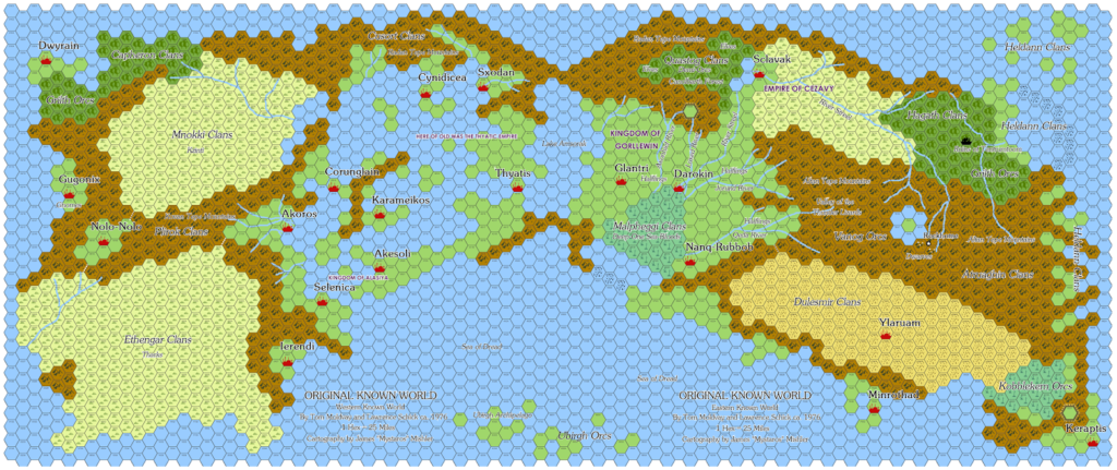
Map 0: The Proto-Known World map
Wait, what? There’s a map zero?!? That’s right — Lawrence Schick posted about it back in 2015. (Thanks to Travis Henry for suggesting that we start with it.)
James Mishler created a replica, combining text labels with the original map. He then continued to interview Lawrence Schick, who provided some more information, including more map labels.
The relevant articles are:
- The Known World D&D Setting: A Secret History by Lawrence Schick
- The Original Known World by James Mishler
- Lawrence Schick Answers Q’s on the Original Known World by James Mishler
- Another Round of Q’s Answered by Lawrence Schick by James Mishler
- Final Round of Q’s Answered by Lawrence Schick by James Mishler
The map itself is entirely different from and incompatible with all later Known World maps. But it nonetheless includes many names that were incorporated into the Known World — as well as many that were not.
Drawing from the lists in Lawrence Schick’s post, here are the Mystara names that appeared in the original map:
- Cities: Akesoli, Akoros, Corunglain, Cynidicea, Darokin, Glantri, Ierendi, Karameikos, Minrothad, Selenica, Thyatis, Ylaruam
- Tribes: Atruaghin, Ethengar, Heldann, Malpheggi
- Misc: Kingdom of Alasiya, Altan Tepe Mountains, Lake Amsorak, Canolbarth Forest, The Streel
A lot of these made their way into the Known World unchanged, while some were reassigned to something different:
- Akoros remained a city but became Akorros
- Cities became the capitals of their own countries with the same names
- Karameikos became a country rather than a city
- The “Tribes” changed from largely humanoid to mostly human cultures
- Malpheggi became the name of a swamp
- Alasiya became the desert where Ylaruam is located (it’s interesting to note that the two are unrelated in the original map)
And here are the extra names from James Mishler’s interviews:
- Known World, Rockhome, Sea of Dread
It’s interesting to hear that they referred to the setting as “The Known World”, because as we will see going forward, this title did not in fact appear until quite late on, with the first published instance seeming to be 1985’s Master Rules Set.
The names that were not brought across to X1 could potentially be used as names to expand undeveloped areas of Mystara, but this is somewhat outside the scope of this project.
If you have any further analysis of this stuff, please feel free to chip in.
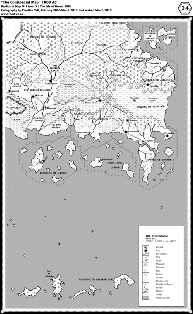
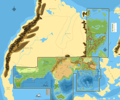
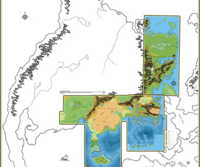
Map 1: “The Continental Map” from X1 (1981)
From the Atlas of Mystara:
This is the seminal, iconic map from which the world of Mystara was born. It introduces all of the now-familiar Known World countries. What it lacks in detail, it makes up for in sheer potential — which thousands of DMs have taken great advantage of over the years, and later supplements expanded and built upon wonderfully.
Additions
- Borders — full borders for all Nations added (see below), except the Atruaghin Clans, the Princes of Glantri, and the Heldann Freeholds. The Emirate of Ylaruam is missing a sea border.
- Coastline — from the coast of the Atruaghin Clans to the southern part of the Heldann Freeholds
- Islands — the islands of Ierendi, Minrothad, Thyatis, and Ostland; the Thanegioth Archipelago; and ten small islands scattered across the as-yet-unnamed sea. Ostland’s western isles are partially obscured by a label, though their coastline is actually visible.
- Nations — Atruaghin Clans, Republic of Darokin, Ethengar Khanate, the Five Shires, Princes of Glantri, Kingdom of Ierendi, Grand Duchy of Karameikos, Heldann Freeholds, Minrothad Guilds, Kingdom of Ostland, Rockhome, Soderfjord Jarldoms, Empire of Thyatis, Kingdom of Vestland. (But see also Revisions/Nations below.)
- Plateaus — the eastern part of the Atruaghin Clans plateau, as well as the southeastern part of the plateau northwest of Glantri, albeit both as yet unnamed.
- Settlements — Biazzan, Castellan, Kerendas, Tel Akbir.
- Terrain — Cruth Mountains, the Isle of Dread.
- Trade Routes — three main routes connect to the Alasiyan Desert, although trails are not shown within the desert itself: Akorros-Darokin-Selenica-Alasiya, Soderfjord-Castellan-Alasiya, and Thyatis-Kerendas-Biazzan-Alasiya. Two segments of this are trails (Darokin-Selenica and Soderfjord-Castellan), while the rest is road. A fourth route leads through Rockhome to the desert.
Revisions
- Nations — many OKW map cities (Darokin, Glantri, Ierendi, Minrothad, Thyatis, Ylaruam) became nations, using the original name for both the name of the capital city as well as the nation itself. Karameikos went from city to nation. Atruaghin, Ethengar and Heldann went from tribe to nation.
- Settlements — many OKW map cities (Akesoli, Akoros, Corunglain, Cynidicea, Darokin, Glantri, Ierendi, Karameikos, Minrothad, Selenica, Thyatis, Ylaruam) became settlements on X1’s map.
- Spelling — Akoros (OKW map) became Akorros.
- Terrain — many OKW map labels (Altan Tepe Mountains, Lake Amsorak, Canolbarth Forest, The Streel) became terrain of the same type on X1’s map. Kingdom of Alasiya became the Alasiyan Desert. Malpheggi went from tribe name to swamp.
Hex Art & Fonts
- Fonts— Souvenir.
- New Symbols — Capital (five pointed star in a circle), City (filled circle in a circle), Paved Road (white line bordered by two black lines), Trail (dotted line comprised of small X’s), River, Mountain (grey triangle), Volcano (white triangle with grey outline), Hills (three linked curves), Forest (a single deciduous tree), Swamp (five dashes pointing upwards arranged in an arc), Broken Land (upside down W shape), Grassland/Steppe (five lines arranged like a grass tuft), Border, Plateau (solid line with short lines extending away from it showing the slope), Jungle (a single palm tree), and Desert.
Textual Additions (X1 1981)
- Climate — “general weather patterns of this part of the continent move from west to east. Hence, much rain falls on the western edge of the Altan Tepe mountains, while little or none falls on the Alasiyan desert. The warm offshore currents near Thyatis and Minrothad modify the weather somewhat in the south, making the climate there similar to the Mediterranean.” Also, “southern farm lands are extremely fertile, due to a thick layer of rich ash from the ancient volcanic hills. The farmers have discovered better ways to grow most crops. The heavily irrigated and terraced gardens of the southern farmlands produce more food than any other area on the map.” And, “The climate in the Thanegioth Archipelago is tropical, similar to the Pacific South Seas islands (Oceania) and the Caribbean. The climate south of the Cruth mountains (running west to east) is moist and temperate, with mild winters. The climate of Darokin and Glantri is warm and sunny, similar to that of southern France. The climate of the Ethengar steppes is mild in the summer, but cold and bleak in the winter, like the Russian steppes around the Black Sea. The climate of the northeastern coast is wet and mostly overcast, similar to that of Denmark.” (p. 4)
- Government — Glantri: magocracy, Ethengar: warring clans, Heldann: independent homesteads, Ostland: monarchy, Vestland: monarchy, Soderfjord: monarchy, Broken Lands: anarchy, Rockhome: dwarven homeland, Atruaghin: clans, Darokin: plutocracy, Alfheim: elven monarchy, Ylaruam: monarchy, Five Shires: halfling federation, Karameikos: grand duchy, Ierendi: oligarchy, Minrothad: syndicracy, Thyatis: autocracy. (p. 3)
- Nations — although the map had a different name, the text provides the familiar “Principalities of Glantri”. Similarly, though the map is missing a label for the elven homeland, the text provides “Alfheim”. (p. 3)
- Races — Alfheim: elves, Broken Lands: outcasts and monsters, Five Shires: halflings, Rockhome: dwarves. Everything else is assumed to be human. (p. 3)
- Real-world analogy — Ethengar: horsemen of the Asian steppes (Huns, Mongols, Magyars, Turks, and so on). Heldann: medieval Iceland. Vestland, Ostland and Soderfjord: vikings. Darokin: Venice or Genoa in medieval Italy. Ylaruam: Arabic desert states or the Central Asian city-states of Palmyra, Damascus, or Samarkand. Thyatis: medieval Byzantine empire. (p. 3)
- Rulers — Only one name is provided, along with the titles for most of the nations’ rulers. Glantri: princes and princesses; local councils of elders and princely stewards; one prince elected “dictator” for one year in emergency. Ethengar: usually no leader, occasionally a strong “khan” unites the warring clans. Heldann: no ruler. Vestland: king. Ostland: king. Soderfjord: jarl. Atruaghin: usually no leader, but temporary elected leader in times of war. Alfheim: king. Ylaruam: emir. Five Shires: five sheriffs (one for each shire). Karameikos: Duke Stephan Karameikos. Ierendi: king and queen as figureheads, but actually certain aristocratic families. Minrothad: heads of the various trading guilds. Thyatis: emperor. (p. 3)
- Settlements — Glantrian princes and princesses are said to each have “a castle hidden in some remote wilderness area”. (p. 3)
- Terrain — Canolbarth Forest: “Because Canolbarth is tended by the elves, it is far larger than a natural forest in this area would be”. Thyatis canal: the channel between Thyatis and the large island to its south is said to be a canal, with the island in fact being a peninsula. However, the map clearly shows it to be channel. Ylaruam oasis: Ylaruam is “built in the midst of the largest oasis in the Alasiyan Desert”. (p. 3)
- Trade routes — Rockhome road: the dwarves “built and maintain the road through the mountains for caravans. They charge a toll from all who pass”. Alfheim trail: “Darokin pays the elves to protect the caravan route through the forest to Selenica”. Ylaruam: this city is said to be the the centre of caravan routes running north to south and east to west, although the map only marks trails leading to the edge of the desert. (p. 3)
Now it’s your turn!
Do you have anything to add to the map? Get out your copy of X1 (1981) and let me know. But remember to keep your contributions limited to the maps posted so far.
Up next: we’ll add the larger scale maps from X1, the Isle of Dread itself and its central plateau.
12 April 2018 @ 11:18 pm
That original map is such a cool treasure. I started with the Moldvay box in 83 before Mentzer was out, got first Expert, then waited for Companion. I never knew until recently about this original map or who started it. The connection with OD&D can be seen with the reference to the tharks. Such cool stuff.
13 April 2018 @ 8:25 am
The Hex Art (terrain symbols) are introduced in the ’81 Expert Rulebook (p. X62), although they did suggest an odd scale (1 hex = 36 miles).
13 April 2018 @ 8:29 am
The Expert Rulebook and X1 are basically concurrent, since they were released together. But I need to work through these one by one, so I decided to do this one first. Expert Set is coming up right after X1, at which point I intend to adopt the hex art you mentioned for the web map going forward. It makes a nice contrast to the later Gazetteer art, while still being authentic to the time period.
I guess I should also have noted somewhere that there’s no colour yet, but my web map is going to be colour from the start.
13 April 2018 @ 9:31 am
I could see someone having a whole B/X campaign based on Moldvay’s modules and the unpublished Known World map: https://index.rpg.net/display-search.phtml?key=contributor&value=Tom+Moldvay
13 April 2018 @ 2:06 pm
Hey Thorf. Is the idea here that you start with a map, and as you explore each of the books add details to the same map, or is it simply recreate the map from the book and complete it with information available from the same book?
13 April 2018 @ 5:07 pm
I’m going to be compiling everything into the same map. So this first post began with X1’s map and added things to it from its text, but the next posts will all build on this foundation rather than standing alone. I’m thinking I’ll do this through the web map, by posting a new version of it with each post. Posting static image versions of these maps is of course also an option.
X1 (1981) Known World, 24 miles per hex | Atlas of Mystara
1 November 2018 @ 2:16 pm
[…] For the full context of this map, including potential textual additions, see Let’s Map Mystara 1981, Part I. […]
Moldvay & Schick’s Known World | Atlas of Mystara
11 April 2021 @ 9:08 pm
[…] This is map 0. It was created c. 1976, and first published online in 2015. For the full context of this map in Mystara’s publication history, see Let’s Map Mystara 1981 Part I. […]
Known World, 24 miles per hex (1981) | Atlas of Mystara
5 August 2021 @ 7:25 pm
[…] Let’s Map Mystara 1981 I — the original project thread for this map […]