Let’s Map Mystara 1985
After a slow start, 1985 turned out to be Mystara’s biggest year yet, with the release of the full world map, as well as hex maps further increasing detailed coverage of the world.
Mystara Geographic Maps 1985
| Map | Name | Hex | Year | M | Source | Reference |
|---|---|---|---|---|---|---|
| 29 | Map E — The Emerlas | 3 | 1985 | 2 | O2 Blade of Vengeance | Cover Gatefold |
| 30 | Player's Wilderness Map | - | 1985 | 2 | O2 Blade of Vengeance | p. 31 |
| 31 | Dominion of Vyolstagrad | 2 | 1985 | 4 | CM4 Earthshaker! | p. 13 |
| 32 | The Known World | - | 1985 | 6 | Master Set | Master DM's Book Inside Cover |
| 33 | The Wilderness | 1/6 | 1985 | 7 | CM5 Mystery of the Snow Pearls | Cover Gatefold |
| 34 | DM Map #1 - Sea of Alphatia | 150 | 1985 | 10 | M1 Into the Maelstrom | p. 3 |
| 34 | Players Map | 150 | 1985 | 10 | M1 Into the Maelstrom | Cover Gatefold |
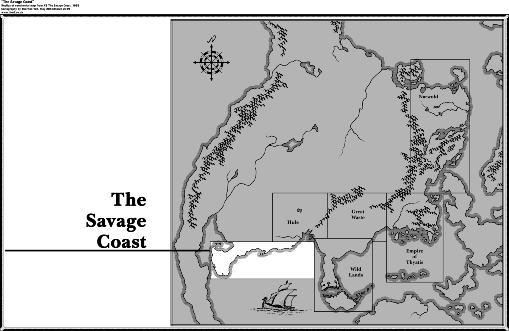
| 35 | The Savage Coast | - | 1985 | 10 | X9 The Savage Coast | p. 13, 20 |
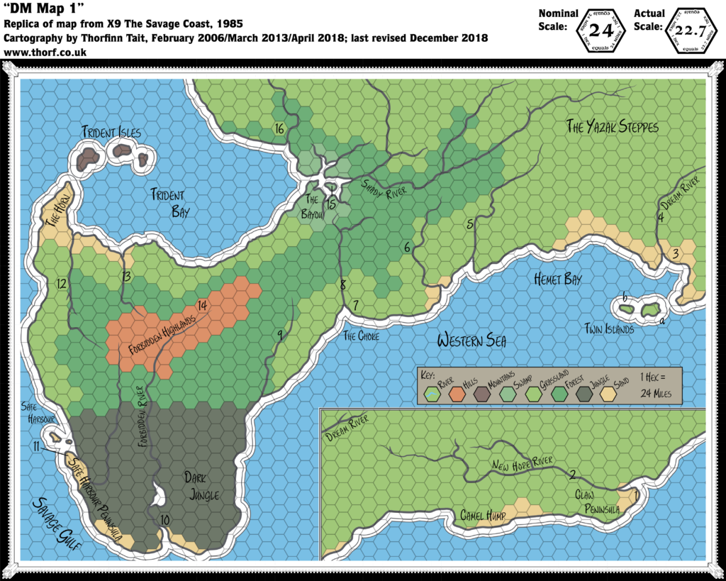
| 36 | DM Map 1 | 24 | 1985 | 10 | X9 The Savage Coast | Cover Gatefold |
| 36 | The Players Map | 24 | 1985 | 10 | X9 The Savage Coast | p. 19 |
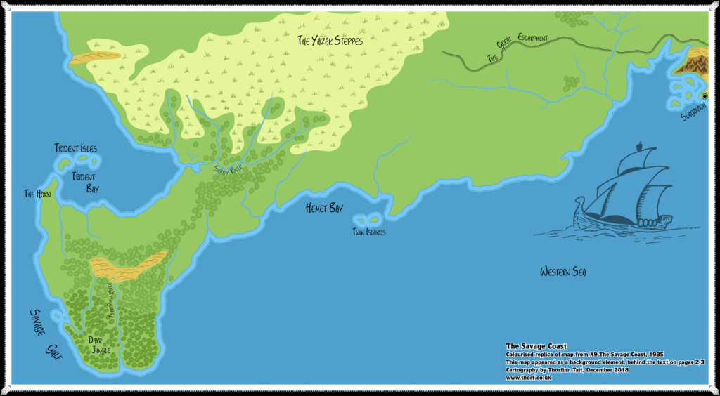
| 37 | [Savage Coast] | - | 1985 | 10 | X9 The Savage Coast | p. 2-3 |
| 38 | [Known World] | 24 | 1985 | 11 | X10 Red Arrow, Black Shield | Poster Map |
| 39 | Grand Duchy of Karameikos | 6 | 1985 | 11 | X10 Red Arrow, Black Shield | p. 15 |
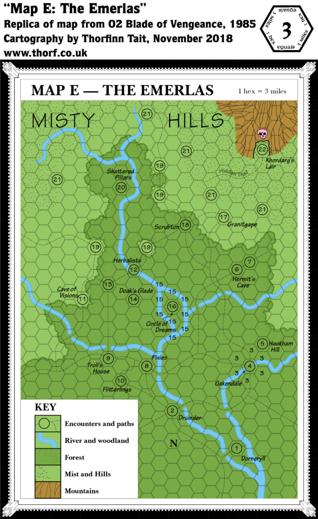
Map 29: “Map E — The Emerlas” from O2 (February 1985)
From the Atlas of Mystara:
The solo adventure Blade of Vengeance (1985) provided a first up-close view of the elven nation of Alfheim, in the form of its Emerlas region of the Canolbarth Forest. This small area at the northern tip of the vast forest is home not only to elves but also a range of other sylvan creatures, and even features human, halfling, and dwarven villages at its edges. In fact if anything it’s a bit short of elves, although this is likely due to the adventure’s premise.
Additions
- Islands — None, although there is an area of land surrounded on all sides by a river.
- Mountains — A single mountain or mountainous area in the northeast, unnamed.
- Nations — No nations or borders are marked.
- Rivers — A major river system runs through the area, unnamed on the map.
- Settlements — Dorneryll, Granitgape, Oakendale and Scrubton.
- Terrain — The Emerlas, apparently the name of this area of forest — which is presumably part of the Canolbarth Forest marked in previous maps. North of the forest’s limits, across a few miles of plains, are the Misty Hills.
- Trails & Roads — An extensive network of paths thread through the area.
Hex Art & Fonts
- Fonts — Hand-written text throughout.
- New Symbols — The map is hand drawn, mostly using area patterns instead of symbols. Forest is a green-coloured cloud-shape. “Mist and Hills” is a paler green with a dot pattern. Mountains are grey with ridge-lines marked. The only symbol is a pink skull for the dragon’s lair. The compass is like an arrow made from bamboo.
Map 30: “Player’s Wilderness Map” from O2 (February 1985)
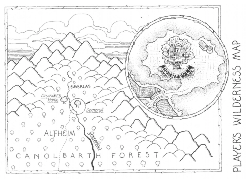
Additions
- Rivers — The main river of the area is named the Greenflow. (See also Revisions below.)
- Terrain — The area around the northern tip of the Canolbarth Forest is shown to be hills and mountains.
- Trails & Roads — The trail from Dorneryll is shown to proceed (roughly) south southeast into the heart of the Canolbarth.
Revisions
- Rivers — The course of the Greenflow is rather different to the rivers of the DM’s map, and its tributaries are not shown at all. If anything, this enhances the impression that this is more illustration than map.
Hex Art & Fonts
- Fonts — Hand-written text throughout.
- New Symbols — Hand-drawn, symbolic style.
Textual Additions (O2 1985)
- Government — The area as a whole does not seem to have had any central government, even before Khordarg’s devastation.
- Military — The main force in the area is the red dragon Khordarg and her army of humanoids. Each settlement has its own militia, but most of these have already been destroyed before the start of the adventure; the only surviving town is Oakendale, with a 10-strong halfling militia (p. 12).
- Nations — Nominally part of Alfheim (referenced on p. 2-3).
- Placement — “The northern tip of Canolbarth Forest (Map 2 Expert Rulebook – page 33) is a wild and beautiful area known as the Emerlas.” (p. 2)
- Races — Interestingly, there are human, dwarven, and halfling communities in the Emerlas region. It’s unclear if these are part of Alfheim or on the border.
- Settlements — The adventure introduces four settlements, but most of these are in ruins even as the adventure begins. Dorneryll was an elven village (p. 2, 4-7), population 17 (p. 5) before its ruin. 8 “distant kin from Alfheim” return with the hero at the end of the adventure, with the intent of restoring the village (p. 26), so the post-adventure population is presumably 9 elves. Granitgape was a dwarven stronghold (p. 2, 18-19), population unknown. It remains a ruin. Oakendale is the only surviving settlement (p. 12-13), although it may well be destroyed during the course of O2’s action (p. 10-11). It is a halfling village, population 46 (p. 12). Scrubton was a human village, population unknown. It was burnt to the ground by Khordarg. (p. 19)
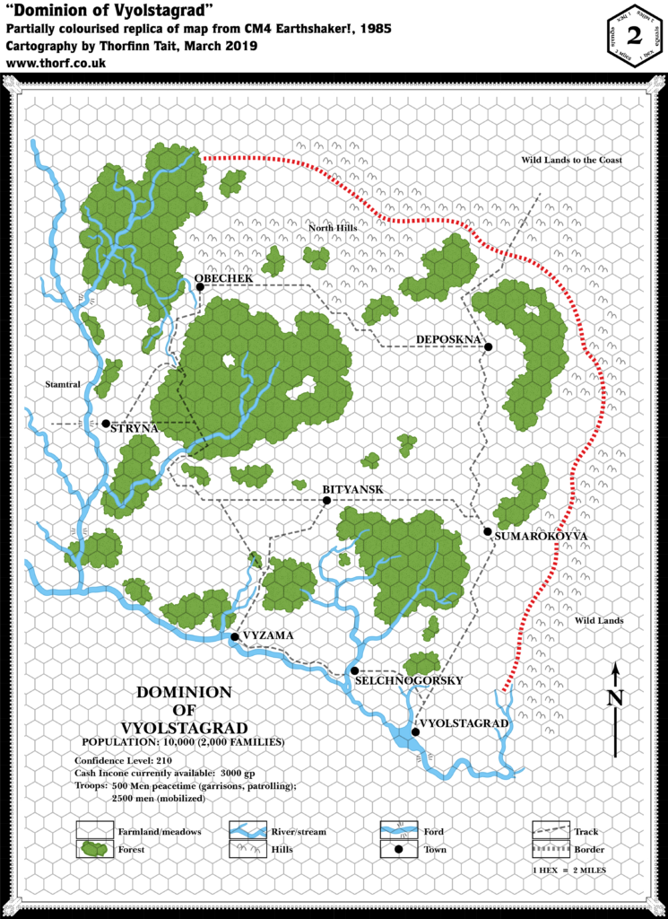
Map 31: “Dominion of Vyolstagrad” from CM4 (April 1985)
From the Atlas of Mystara:
1985’s Earthshaker! provided another close-up example of a Companion Set-style dominion. It’s a peculiar map, with no border and no clear indication of where it begins and ends.
Additions
- Borders — A border is only shown on the north and east sides of the dominion. The inference seems to be that the river forms a natural border to the south and west.
- Dominions — The Dominion of Vyolstagrad. A label “Stamtral” on the western edge of the map could be interpreted as the name of a neighbouring dominion. The eastern and northeastern edges are both marked as “Wild Lands”, presumably unsettled.
- Fords — A number of unnamed fords are marked.
- Islands — One tiny island in the equally tiny lake south of Selchnogorsky.
- Lakes — Vyolstagrad town sits on the northeastern shore of a small lake. There also appears to be a small lake with an island in its centre just south of Selchnogorsky.
- Military — Unusually, the map itself lists a militia of 500 in peacetime, including garrisons and patrols, with 2,500 when mobilised for war. It’s not clear if these figures are included in or in addition to civilian population.
- Rivers — A rather extensive river network, but with no names.
- Settlements — Vyolstagrad, Bityansk, Deposkna, Obechek, Selchnogorsky, Stryna, Sumarokoyva, Vyzama — all “towns”. The map lists dominion population at 10,000, suggesting an average population of 1,250, or 250 families.
- Terrain — The most peculiar feature of the map is the way the terrain simply stops at the apparent edges of the dominion. The map largely uses terrain (hills and rivers) to define the extent of the dominion, with everything outside that being blank hexes — which are also used to show “farmland/meadows”, thus leaving the edges of the map ambiguous. Within Vyolstagrad, there are extensive unnamed forests dotting the farmlands. The only named terrain feature is the North Hills, the only major part of the surrounding hills located within the dominion’s borders.
- Trails & Roads — No roads, but an extensive network of “tracks” links the settlements. The trail leading into the unknown northeastern corner of the map ends in the label “Wild Lands to the Coast”, suggesting that the nearest coast is in that direction.
Hex Art & Fonts
- Fonts — Baskerville throughout.
- New Symbols — Hills symbol is more pointy than usual, with only two peaks. Ford (six lines leading away from a river crossing point, three on each side).
Textual Additions (CM4 1985)
- Dominions — The western map label is confirmed to be the Dominion of Stamtral (p. 5-6).
- Placement — Vyolstagrad is said to be “somewhere near the Wyrmsteeth Range” (p. 2).
- Races — The depiction of gnomes in CM4 suggests that they are demi-humans just like elves, dwarves and halflings, complete with Clanmaster, Keeper, and indeed Relic (p. 3).
- Rulers — Vyolstagrad is lead by Duke Nevik (p. 2). Stamtral is lead by Duke Stamtral (p. 23).
- Settlements — Stryna is noted to be a village rather than a town (p. 5-6).
Map 32: “The Known World” from Master Set (June 1985)
From the Atlas of Mystara:
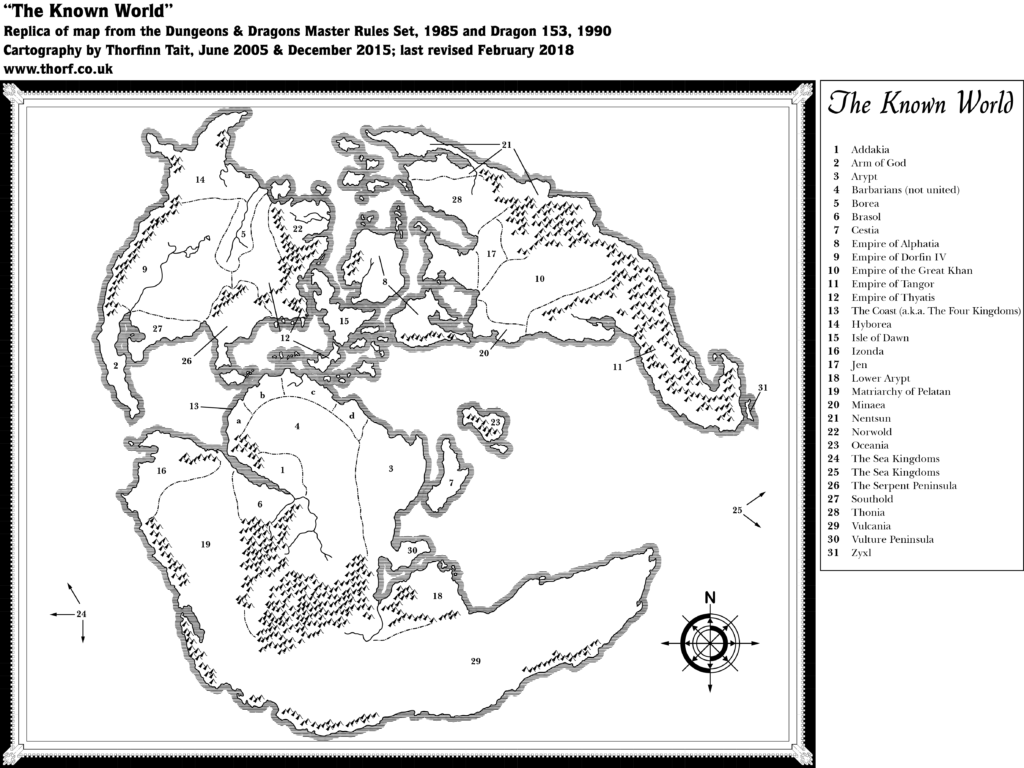
Mystara’s first world map appeared in the DM’s guide of the Master Rules Set (1985). The continent of Brun, along with a small part of Davania, had appeared the previous year in the Companion Rules Set (1984) and CM1 Test of the Warlords(1984).
The inspiration for this map is prehistorical maps of ancient Earth — Jurassic Earth, to be precise, around 150 million years ago. The map which this map was probably inspired from was featured in Continents in Collision (1983), a Time Life book in the Planet Earth series. Many fans spotted the similarities back in the 80s, though the map was not posted online until it was unearthed once again in February 2018. For the full story, see this article on thorfmaps.com.
Additions
- Coastline — Although still as yet unnamed, Skothar, Bellissaria, and the vast majority of Davania (all but the northern tip) appear here for the first time, as do Brun’s northern and southern extremities. Various small islands between the main continents also appear in their complete form for the first time.
- Continents — With the publication of the world map, it now becomes clear that the world has three major continents, with a number of smaller island-continents in between. However, there are still no names at this stage. So even though I keep referring to Brun, Skothar and Davania, this is merely out of convenience; these names had not yet appeared in 1985.
- Islands — Cestia, Oceania, and Zyxl appear for the first time, with their names in the legend. Various small islands shown on previous maps, including two of what will later become known as the Pearl Islands (between the Isle of Dawn and the southern continent), do not appear on this map. This can be attributed to the scale, as small details are often left out of world maps.
- Mountains — All mountains outside of Brun and western Alphatia appear for the first time on this map.
- Nations — It’s unclear which of the entries in the legend are nations and which are simply geographical names. (See also Regions below.)
- Previously named nations appearing here are: Empire of Alphatia, Empire of Thyatis. Alphatia is applied to the large island marked as such on previous maps, but also to the island to its southeast (later known as Bellissaria). Thyatis had appeared as a bordered area from X1’s map onwards, but here it is shown to cover a much wider area, with three lines indicating the area from mainland Thyatis to northwest of Glantri, and southeast to the large island that will later be named Ochalea.
- Explicit nations added on this map are: Barbarians (not united), Empire of Dorfin IV, Empire of the Great Khan, Empire of Tangor, The Coast (a.k.a. The Four Kingdoms), Matriarchy of Pelatan, and The Sea Kingdoms — the last of which is simply a label pointing to blank sea areas at each side of the map.
- Regions — Isle of Dawn, Norwold, and The Serpent Peninsula we are already familiar with as regional names. The Arm of God and Vulture Peninsula also both seem to explicitly delineate geographical regions. In addition to these, many labels are provided without any indication of their status as either political or geographical areas. The former have been listed above under “Nations”; another three clearly indicate “Islands”; the rest are as follows: Addakia, Arypt, Borea, Brasol, Hyborea, Izonda, Jen, Lower Arypt, Minaea, Nentsun, Southold, Thonia, Vulcania.
- Rivers — Only a few major rivers are marked, all unnamed. Of these, those in Alphatia, northern Skothar, and two in central Davania are new with this map.
- Seas — As with the land, this map provides a complete view of Mystara’s seas. Or rather it would if the map were not clipped to fit the page. (See Analysis below.)
- Terrain — Arm of God, Isle of Dawn, The Serpent Peninsula, and Vulture Peninsula all seem to explicitly delineate geographical regions. In addition to these, many labels are provided without any indication of their status as either political or geographical areas. The former have been listed above under “Nations”; the rest are as follows: Addakia, Arypt, Borea, Brasol, Cestia, Hyborea, Izonda, Jen, Lower Arypt, Minaea, Nentsun, Oceania, Southold, Thonia, Vulcania, Zyxl.
Revisions
- Borders — See above under “Nations”.
- Coastline — Although the coastlines largely match up, the continent of Brun and surrounding islands as shown on previous continental maps have been rotated 2.68º anticlockwise. To fit previous maps onto the world map, this rotation must be taken into account.
Hex Art & Fonts
- Fonts — Quill (map title), Baskerville (everything else).
- New Symbols — Art is in the same style as 1984’s continental maps.
Textual Additions (Master Set 1985)
- Planes — the dragon rulers are said to have home planes in the Outer Planes. It’s unclear from the text whether this is one plane for all four, or four separate planes: “If a dragon ruler’s material body is slain, the spirit goes to its home plane (one of the Outer Planes) and creates a new body.” (DM p. 29)
Analysis
There is surprisingly little setting information in the Master Set, despite its inclusion of the world map. Indeed, the key to the world map provides the only new information, but with no associated text or explanation of any kind. So we are left wondering about all of the tantalising, mysterious names in the map’s key: what kind of land is Vulcania? Who is the Great Khan, and what is his empire like? What do the people of Zyxl have against vowels? And just who is this Dorfin fellow?
This is the first map to use the name “Known World“, and perhaps even the first Mystara product to do so. (1984’s XSOLO used the phrase uncapitalised in its text.) Here, it clearly refers to the entire world, and presumably it’s from this point on that the world itself began to be referred to by that name.
Years later, in 2006, Frank Mentzer answered some questions about the origins of the names on this map. Let’s take a look at what he said. Some comments are in response to a list of suppositions posted by Shane H, which Frank responded positively to. Only Frank’s comments are included here, but it’s worth looking at Shane’s list, too.
- Cestia — “Derives from the Greek rather than the Latin, and is another matriarchy.” The reference is to Greek cestus, which according to Wiktionary is “A girdle, especially that of Aphrodite (or Venus) which gave the wearer the power to excite love”
- Dorfin — “A tangent reference to Amber.” Presumably refers to The Chronicles of Amber by Roger Zelazny.
- Izonda — “From whole cloth.” Seems to mean it’s just made up.
- Jen — “? Doesn’t ring a bell… are you sure this one’s mine? No notable mythico-historical referent in any event.”
- Minaea — “Sea traders & specialists in bronze, famed for the Labyrinth; Minoa (q.v.); destined to fall because of the rise of iron & steel worldwide”
- Nentsun — “nent (arch., about/towards) [the] -sun, ie land of eternal sun”
- Pelatan — “No idea, but it sounds French… probably something from Francois and/or Bruce Heard.”
- Tangor — “Tip o’ the hat to Burroughs again… do your homework. ;> ” Refers to an Edgar Rice Burroughs novella, Tangor Returns.
- Real world sources — “Some are obvious and derivative… Hyborea, Arypt (Egypt), Brasol (Brazil), Hyborea and the related Borea, Oceania of many legends, Northworld (Norwold) and the corresponding Southold, and the Empire of the Khans (corresponding to the empires of central Asia). Some were completely fantastic but undetailed, while some are mentioned in my preplanning notes (like the Arm of God and Zyxl) but were never completed.”
- Robert E. Howard influence — “There’s a lot of REH influence throughout.”
- Thonia — “Rather than from Blackmoor, is more easily searched if you put a “C” on the front. … Try http://en.wikipedia.org/wiki/Chthonic.” It refers to the Underworld.
- Thyatis — “Grandfathered, the name invented by either Zeb or Tom M.” We now know this to be Tom Moldvay and Lawrence Schick.
- Vulture Peninsula — “Note the plethora of unusual life forms in historical Madacascar.”
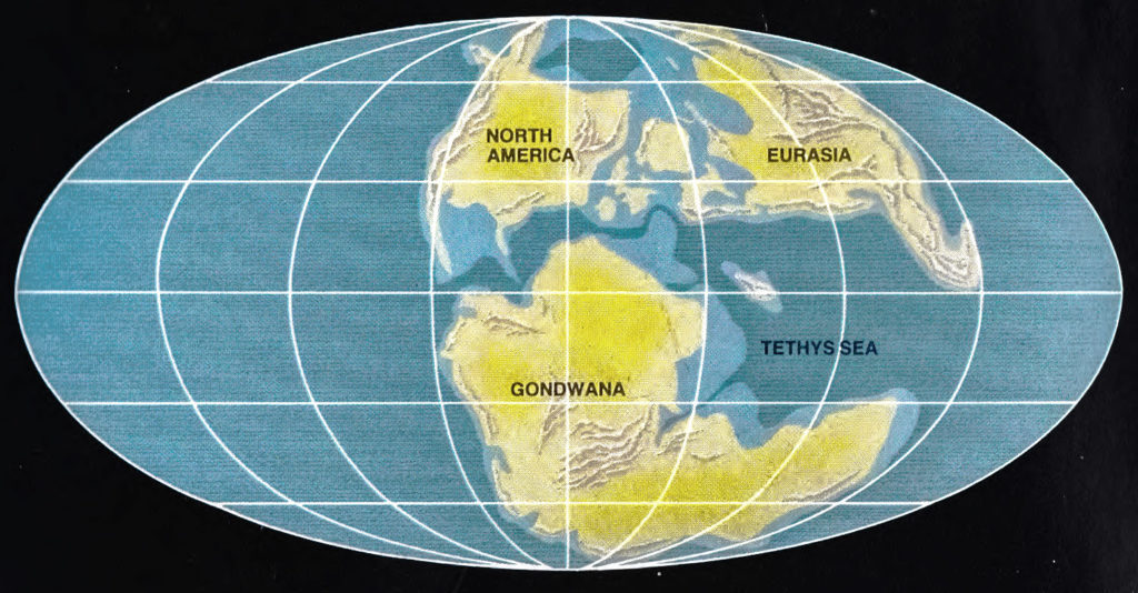
Map: Earth 135 million years ago
The map which this map was probably inspired from was featured on page 162 of Continents in Collision (1983), a Time Life book in the Planet Earth series.
Let’s take a moment to examine the map which (likely) inspired the Master Set world map. It was drafted by paleogeographer Dr. Christopher Scotese in the early 1980s, one of a set of six maps depicting “The Once and Future Earth”. According to Dr. Scotese, Time Life artists drew the final maps based on his designs.
The Master Set map was apparently conceived by Francois Froideval. Frank Mentzer stated as follows: “Early in the period that I was developing BECMI I had openly invited everyone to contribute or participate, and Francois retooled the historical map of Pangaea (Earth before continental drift) as a suggestion for my new world, and I accepted it and took it from there.” (Dragonsfoot, 2006) Froideval must have seen Dr. Scotese’s maps in Continents in Collision. The third map in the series, showing the Earth “135 million years ago”, was the map chosen as inspiration.
It’s worth noting that even before the book was published this map was effectively out of date, as paleogeographic understanding of tectonic plate shifts was continually evolving. As a result, even near-contemporary maps by the same cartographer show quite different continental configurations — and today’s maps of that era are altogether different in detail, even if they retain a basic sense of overall similarity. (This also explains why I usually refer to the map as “Jurassic Earth”, even though technically 135 million years ago is Cretaceous; nowadays, the maps bearing most resemblance to Mystara are those dated at roughly 150 million years, which is late Jurassic.)
Although the Jurassic Earth inspiration for the shapes of the continents was common knowledge at the time, it would be another 30 years or more before Mystara’s cartographers utilised this knowledge to properly georeference the globe. (Inability to find the exact original map on the Internet doubtless played a part in this delay.) In the meantime, the connection between the Jurassic map and Mystara’s world map — and especially the fact that it defined Mystara’s projection — was largely overlooked. The Master Setworld map was presented within a rectangular border, without the proper Mollweide projection border, and the large ocean that took up almost half of Jurassic Earth was cropped. This naturally led to confusion as to the extent of the ocean, and indeed the shape of the world.
Of course, the Jurassic map itself isn’t directly a part of Mystara’s cartographic chronology. Nevertheless, it can be very useful to us to provide details not explicit in the Master Set map derived from it. And since all of this information was indeed available back in 1985, I’m going to incorporate all of this into this project. Specifically, a comparison of the two maps reveals three aspects we can use:
- As already mentioned above, the map uses the Mollweide projection. This is critical to establishing the shape of the world, and yet it was obscured in the Master Set map’s presentation.
- The close correlation between the land masses and terrain allows the Jurassic map to be used to interpret the internal shapes of the mountain ranges (especially useful for central Davania’s large clump of mountains).
- The continental shelves/ocean depths marked here can be adapted to Mystara’s land masses quite easily.
The importance of knowing the correct projection can’t be overstated, as every (Outer World) Mystara map can be placed on this world map — meaning that they all share the same projection, which we now know to be the Mollweide projection. This allows us to determine geodetic coordinates for every point on Mystara.
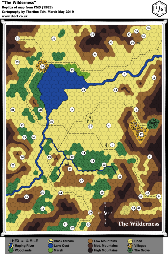
Map 33: “The Wilderness” from CM5 (July 1985)
From the Atlas of Mystara:
CM5 was a peculiar module, with its red ink and magic viewer system, and this map also fits that image. It has a weird scale, which at 1/6 of a mile means 880 ft. per hex, making it one of the largest scale wilderness hex maps printed for Mystara. It’s also filled with mysteries, as it effectively served as the game board for the solo adventure. It’s also little-known these days, and is one of the few maps passed over by most of the community; when almost everything else has now been placed in Mystara, “The Wilderness” seems to have had only one attempt so far.
Additions
- Bridges — A single bridge across the upper Raging River.
- Dominions — None. The area shown on the map is less than one 8 mile hex, so it could conceivably be a small part of a dominion.
- Fauna — What looks like an eagle’s head appears next to the numeral 36.
- Lakes — Lake Oest. The name is not shown on the map, but provided in the key.
- Mountains — Mountains are shown throughout the area, in three heights. The “Low Mountains” could presumably be taken to be hills, since they surround the higher ranges.
- Rivers — A small river system flowing into and then out of Lake Oest. The key appears to name the larger of these “Raging River” and the smaller “Black Stream”.
- Scale — This is the first map to use this scale, and also the largest (most zoomed in) scale to date. 1/6 of a mile translates to 880 ft., or 268 m. — large enough that buildings can almost appear at actual scale. (In practice, the buildings shown on the map are still likely at least 10 times larger than they should be at this scale, and the town areas marked here are likely a bit too spacious.)
- Settlements — Two are shown. (See Scale above.) Neither town is named on the map.
- Terrain — Numerous small patches of forest, a single swamp, and an area marked with a texture that looks like badlands or desert, but unmarked in the key. (Next to area 10.)
- Trails & Roads — Roads (using the art usually applied to trails) throughout the map, none labelled.
Hex Art & Fonts
- Fonts — Baskerville (title), Helvetica (map key), Korinna (compass rose). This marks the debut of Korinna in Mystara maps.
- New Symbols — Art that doesn’t (quite) conform to the hex grid; most terrain is solid colours, except forest and swamp, which have symbolic textures.
Analysis
This area is simply too small to be of much interest to this project. I’ve partially updated the map, but I’m going to skip the Textual Additions for this one, at least for now.
Regarding placement, the module gives very few clues as to where it may be set. It has elves with a Tree of Life, and a few place names, but otherwise there’s nothing. Fan placements are also few and far between, with the only one I’m aware of being in Threshold Issue 10 — but that’s far from our discussions of 1985, so I’ll leave it for later. For now, the map stands alone.
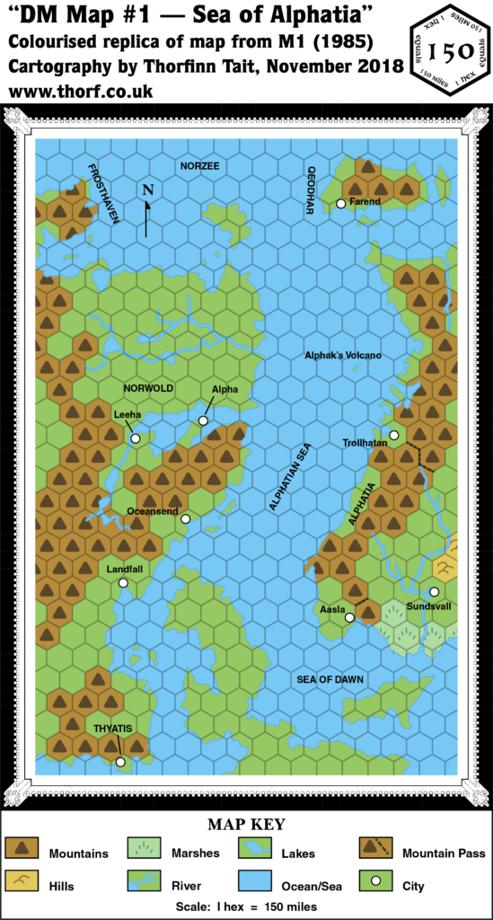
Map 34: “DM Map #1 — Sea of Alphatia” from M1 (October 1985)
From the Atlas of Mystara:
The most interesting feature of this map is its portrayal of Alphatia. At this point, Alphatia had only been seen twice before: the extreme western coast in the Companion Set continental map, and the whole island continent in the Master Set world map. This view in M1 shows about half of Alphatia, but in a rather different configuration: the southwestern spur is a separate island, and the northern part has been drastically expanded. Later maps further revised the landmass.
Additions
- Coastline — See Revisions below.
- Islands — Qeodhar and surrounding isles (nameless for now) appear in full for the first time. Alphak’s Volcano is introduced here, too, although its nature means it is only shown on the DM’s map.
- Mountains — Mainland Alphatia’s mountains have been expanded into the newly-appearing areas. Qeodhar gains mountains for the first time.
- Mountain Passes — Two significant passes are featured: one leading from Aasla into the central lands, and another (much longer) leading from Trollhattan.
- Rivers — Alphatia gets new river systems on this map, with a single river in the northwest and a branching system in the south near Sundsvall. The Sundsvall river system previously appeared on the Master Set map, but this map’s version is completely different.
- Scale — This small scale map of Norwold had a unique scale that would never be used again in published maps. It’s the most zoomed out hex map in Mystara’s history. Unfortunately, comparison with previous maps of the area indicates that the scale is in fact not 150 miles per hex; instead, a scale of about 138 miles per hex facilitates compatibility with other maps.
- Seas — The Alphatian Sea, the Sea of Dawn, and the Norzee all appear here for the first time. The borders of these seas are not entirely clear, but based on the context of this map alone, the Norzee appears to be the northern seas around and between Frosthaven, northern Norwold, Qeodhar, and northern Alphatia; the Alphatian Sea appears to be the area between the continent and Alphatia; and the Sea of Dawn the water between the Isle of Dawn and Alphatia.
- Settlements — Farend in Qeodhar, as well as Aasla, Sundsvall, and Trollhattan in Alphatia all appear here for the first time.
- Terrain — Any kind of detail is impossible at this scale, but Alphatia gains a swamp and some hills around Sundsvall.
Revisions
- Coastline — Alphatia has been expanded from the bits and pieces previously seen on the Companion Set continental map, apparently without reference to the Master Set world map, where it appeared in full. The southwestern spur, shown as part of the main island in the Master Set, is now a separate island, and the main island has been expanded greatly to the north, joining up the disparate parts shown on the edge of the Companion map. Unfortunately only the western half of Alphatia is shown, and at this stage there is no way to reconcile the two very different versions. As for the rest, the coastlines match previous versions quite nicely. The eastern tip of the Isle of Dawn, shown for the first time at this scale, appears much as it was shown on the Master Set map.
- Terrain — As noted in Additions above, the scale makes any kind of terrain detail impossible. Consequently, areas previously shown in larger scales (most of the left half of the map) are here drastically simplified into just plains and mountain hexes.
Hex Art & Fonts
- Fonts — Helvetica, except for the “Map Key” title, which is Baskerville.
- New Symbols — Nothing of significance.
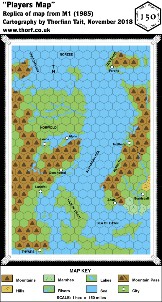
“Players Map” from M1 (October 1985)
Identical to the DM’s Map in most ways, the Players Map was presented in full colour. The differences are outlined below.
Revisions
- Islands — Alphaks’ Volcano doesn’t appear on this map as its location is unknown to the players. The Isle of Dawn is labelled here; the DM’s Map left out this label.
- Spelling — Trollhattan from the DM’s map is here spelled “Trollhatan”. Given the real world city of the same name, this is likely an error.
Textual Additions (M1 1985)
- Climate — “The southern side of Qeodhar (four hexes) benefits from a rare micro-climate permitted by the proximity of high mountains, a warm ocean stream coming from the east, and a profusion of hot springs. The northern side of Qeodhar is affected by a semi-permanent polar climate.” (p. 7) It should come as no surprise to Mystara fans that Bruce Heard would have included detailed climate notes like this. Happily, the Atlas‘s latest climate map does indeed have a warm current coming up from the south through the Alphatian Sea, which could well have an offshoot running past Qeodhar’s southern coast.
- Dominions — Qeodhar is “a dominion under the fealty of Alphatia” (p. 2). The official title is Barony of Qeodhar (p. 3).
- Government — Alphatia is a strong magiocracy, although the word itself isn’t used yet: “The empire built its power on a solid foundation of magic, with no less than a thousand wizards ruling the empire’s council.” (p. 2) While it’s not explicitly stated, Qeodhar is apparently a feudal dominion of the usual Companion Set style. (p. 2-3)
- Military — M1 contains copious fleet write-ups, which are somewhat outside the scope of this project. Qeodhar is noted to have a “1,000-man militia” (p. 7), in addition to its fleets.
- Nations — Alphatia is noted to be “the oldest empire of the world”, while Thyatis “is much younger”. (p. 2) Old Alphatia is said to be “a distant world” in “another part of this galaxy” (p. 7), strongly suggesting that it’s located on the Prime Plane.
- Planes — Alphaks’ Volcano is said to contain “a two-way vortex to a Plane of Death” (p. 2). Contrast this with Alphaks’ description on the same page, where he is noted to be “a temporal from the sphere of Death”. While this could be interpreted as a mix up between the concepts of plane and sphere, I prefer to think “a Plane of Death” refers to a highly entropic plane. Crucially, it’s not referred to as “the” but rather “a Plane of Death”. Despite the capitalisation, I don’t believe this to be a name but rather a description. On the other hand, p. 28 refers to this place as “the Sphere of Death”, indicating a definite mix up between planes and spheres.
- Rulers — Qeodhar is ruled by Baron Norlan (p. 2), whose full title is Baron of Qeodhar, Kjavik of Norzee (p. 6). King Ericall is still ruler of Norwold (p. 2 etc.). Thincol the Brave is again stated to be emperor of Thyatis (p. 3), having been introduced in CM1 the previous year. There is no mention of Eriadna in M1, even though she was also introduced in CM1, and despite the introduction of her daughter, Princess Mariella (p. 6).
- Settlements — Farend is “the major city of Qeodhar”, while Sundsvall is “the imperial capital of Alphatia” (both p. 5).
- Spelling — “Alphak’s Volcano” was marked on the DM’s Map, but the text names the Immortal “Alphaks” (p. 2 etc.), so this should presumably be “Alphaks’ Volcano” — and indeed DM Maps 4 and 5 both use this spelling (p. 17-18).
Analysis
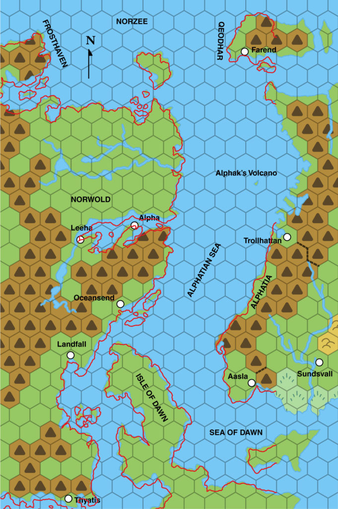
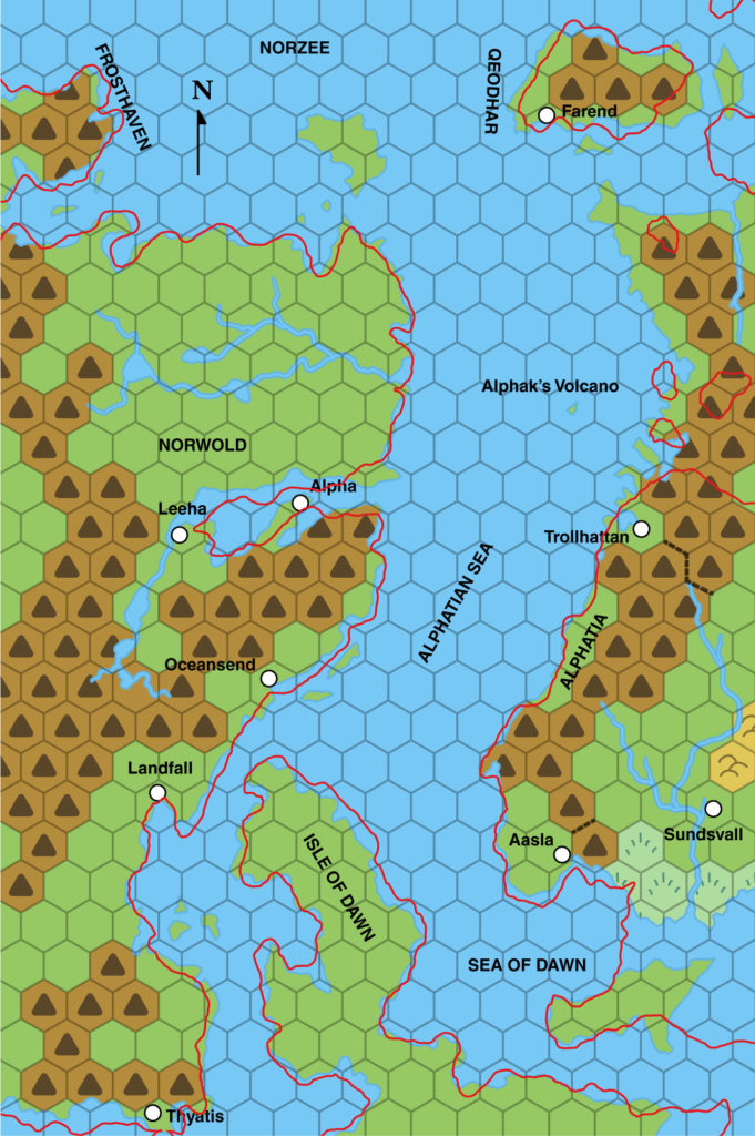
The version of Alphatia presented here is unfortunately incomplete (western half only), and at odds with the shape published just months earlier in the Master Set world map. Let’s take a look at how the coastlines here (interpreted at 138 miles per hex) compare with the continental and world maps.
Note how the rightmost three columns of hexes have clearly been extrapolated from the edge of previous Brun maps. Interestingly, the southernmost spur has been taken to be a separate island, while the northernmost spur has been connected to the Alphatian mainland. The Master Set world map made the opposite decisions in expanding Alphatia, as you can see in the next image:
Note how the southern spur is part of mainland Alphatia on the world map, while everything between Alphatia and the northernmost island (Qeodhar on M1’s map) is completely different.
These two different interpretations are likely the result of simultaneous development of both maps; M1 was probably in development before the Master Set was printed, and the cartographer clearly didn’t get access to the world map. The exact situation and reasons are unknown. Either way, we are left with a choice between the two versions. In 1985 there is not really enough information to decide between them or even to reconcile the two, so I will leave them both as is, awaiting resolution in the light of later developments.
M1 also presents a quite-detailed account of the remains of Old Alphatia, including a number of maps. However, as with CM6 Where Chaos Reigns (also published in 1985), this lies outside the scope of this project. I will doubtless reproduce these maps at a later date, but since they don’t directly affect Mystara, for now they are low on my list of priorities.
Map 35: “The Savage Coast” from X9 (October 1985)
From the Atlas of Mystara:
This simple update of the Companion Set‘s continental map appeared in X9 to show the location of the Savage Coast in relation to other regions. The map itself is nearly identical to the Companion map, but with an extra box for the Savage Coast. It also adopts labels for the regions, which were missing from the previous map.
Additions
- Regions — The Savage Coast region is added to the continental map, alongside the previously established regions from CM1’s map.
Revisions
- Regions — This whole region was previously labelled Southold on the Master Set world map. Here it seems to have been renamed The Savage Coast.
Hex Art & Fonts
- Fonts — Baskerville.
- New Symbols — None.
Analysis
The Master Set was published four months before X9. With just four months in between, it seems likely that the world map was not available (or at least was not made available) to X9’s designers. This is the same situation that we saw with M1’s maps; X9 and M1 were both published in the same month.
In other words, Southold almost certainly wasn’t deliberately changed to Savage Coast; rather, both names probably arose in development around the same time. It’s also possible that someone noticed but by that point X9 The Savage Coast was already too far into development. After all, the concept of “Savage Coast” is pretty central to the module.
In the context of 1985, it might easily have been concluded that Southold was the name for the whole region, including the Yazak Steppes, the Orc’s Head Peninsula, the western Gulf of Hule, and yes the Savage Coast, with the latter term primarily referring to the coastal region.
Map 36: “DM Map 1” from X9 (October 1985)
From the Atlas of Mystara:
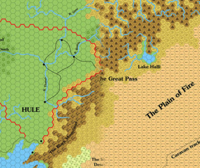
In 1985, X9 expanded the map to the far west, adding the Savage Coast region on to the previous year’s X5 Hule map.
Unfortunately, the join with X5’s map is not at all clear, and in fact highly problematic. It’s perhaps not surprising that this resulted in a legacy of misalignments and inconsistency with this area of the map.
The whole area was redesigned in greater detail in The Voyage of the Princess Ark series in Dragon Magazine, and later consolidated in the Red Steel and Savage Coast campaign sourcebooks.
Additions
- Coastline — From the Gulf of Hule in the east to what will later be called the Grass Coast on Yalu Bay in the west, the whole coastline here appears at this scale for the first time.
- Islands — While most of them appeared previously on the continental map, the Twin Islands, Trident Isles, and the tiny islands of Safe Harbour appear here in detail for the first time.
- Lakes — A small lake in the Dark Jungle.
- Rivers — Four major rivers are named: the Forbidden River, New Hope River, Dream River, and Shady River. All of these have unnamed tributaries, and there are eight other unnamed minor rivers.
- Seas — Hemet Bay and The Choke are bays on the Western Sea. The Savage Gulf is the name of the strait in the far west, although the Arm of God is just off the edge of the map, and doesn’t appear in X9 at all. Safe Harbour is a small bay on the Savage Gulf. Further north, we have Trident Bay.
- Settlements — None marked. See Textual Additions below for details of the numbers marked on the map.
- Spelling — “Hemet Bay” seems like an obvious spelling error, and is most likely supposed to be “Helmet Bay”.
- Terrain — The Yazak Steppes, previously featured in the corner of X5’s map, are expanded here all across the north of the Savage Coast. They were previously marked as grasslands, but here the hex symbols for plains and grasslands have been merged into one symbol, making it hard to see their exact extents. The Claw Peninsula is located at the southwestern edge of the Gulf of Hule (though that name doesn’t appear on this map). Camel Hump is a sandy bump on the coastline to the west of this. The large peninsula to the west (unnamed on the map) includes the Dark Jungle, Safe Harbour Peninsula, the central Forbidden Highlands, surrounded by forests, and The Horn pointing out towards the Trident Isles. Finally, The Bayou is a large swampy region on Trident Bay.
Hex Art & Fonts
- Fonts — Hand-written text throughout.
- New Symbols — None, though the hex “art” is not so much art is coloured hexes.
“The Players Map” from X9 (October 1985)
Nothing to see here. Moving right along…
Map 37: the Savage Coast from X9 (October 1985)
From the Atlas of Mystara:
Ironically, the most complete map of the Savage Coast area included in 1985’s module X9 The Savage Coast was not so much a map as a background to the opening pages of the module. Despite the pages’ text obscuring much of the map, it nevertheless depicts the whole area, from Slagovich in the east to the tip of the Orc’s Head Peninsula in the southwest, from the Great Escarpment to what would later be named the Grass Coast of Yalu Bay.
As such, this map covers a larger area than the module’s accompanying hex map, but in an illustrated rather than hex style. Although it doesn’t have settlements or beaches marked, it otherwise includes all the same terrain as the hex map.
The real significance of the map, though, lies in clearing up the ambiguous join between the Savage Coast and the Gulf of Hule: working just with the hex maps, it’s impossible to see exactly how the authors intended the maps to be joined up, but this map explicitly shows their intent.
Additions
- Coastline — The major contribution of this map is that it makes the join between X9 and X5’s hex maps explicit. The continental map could also be used for this purpose, but since it only included coastlines and a few rivers, this map serves the purpose far better.
- Terrain — As well as reprising most of the hex map’s terrain (minus beaches), this map adds grasslands to the Yazak Steppes (which were plains on X9’s hex map), and of course extends them northwards. The eastern extent is a little different from the part that appeared on X5’s map, but it’s easy to merge these. Finally, there’s a small line of hills in the far west.
Revisions
- Coastline — This map includes all the coasts shown on X9’s hex map, expanding northwest and east. None of this is really new, as it has previously appeared on CM1’s continental map and X5’s hex map. The match is quite good.
- Plateaus — The Great Escarpment appears on this map, but in a slightly different location from X5’s escarpment. The shape is very similar, and the eastern end matches quite well, but as it moves west it skews further north than X5’s.
- Rivers — The rivers mostly line up well with the hex map’s rivers; although their courses are often slightly different, it’s not enough to be significant — and some rivers are less detailed on this map. The northeastern river system largely lines up with X5’s rivers, too. The New Hope River and its tributaries are strangely absent.
Hex Art & Fonts
- Fonts — Hand-written text throughout; matches the text on the hex map.
- New Symbols — Hand-drawn, symbolic style. Forests and jungles are represented by tree-like symbols, while grasslands use the usual grass patch but without hexes. Note that the black and white original map did not show background colours for any of the terrain, so the grassland yellow and the light brown of the hills are my own addition.
Textual Additions (X9 1985)
- Climate — “The general weather patterns move from west to east. There is often a wind from the north, east, and south. The coastal climate of this area is similar to the southeast United States. Inland, the climate is similar to that of the Mediterranean. The mild weather continues even during the winter. Thunderstorms in the Dark Jungle and gentle showers over the rest of the area occur year round.” (p. 2)
- Factions — The adventure introduces a number of competing factions: the Brotherhood of Light (p. 3); their rivals the Lawful Brotherhood (p. 3); and the Neutral Alliance (p. 8). The Lawful Brotherhood is said to have established outposts, and to be interfering with natives and adventurers in the region. (p. 3)
- Fauna — A group of tyrannosaurus rex live on the Twin Islands. (p. 7)
- Placement — The module states that “the eastern edge of DM Map 1 connects with the western edge of the Map of Hule on page 31 of adventure X5, The Temple of Death.” (p. 2) This is vague and rather unhelpful. In fact, the northern edge of the inset part of the map connects with the southern edge of X5’s map — and due to the rotation, it doesn’t even fit very well. Nor is it easy to see how it should fit together without reference to the continental map. (See Analysis below for more on placement.)
- Races — There are mermen living in the coastal waters east of the Claw Peninsula in the Gulf of Hule (p. 4), and near the Twin Islands (p. 6-7). 6 and 9 on the map indicate Aranea lairs (p. 8, 11). Tortles can be found wandering along most of the beaches of the Savage Coast, including at Claw Peninsula, Camel Hump, Twin Island Peninsula, and along Helmet Bay (p. 6, 8).
- Seas — Claw Inlet is the name of the bay north of the Claw Peninsula, on which the New Hope Outpost sits. (p. 6) Helmet Bay‘s spelling on the map (“Hemet”) is confirmed to be a typo (p. 8 etc.).
- Settlements — The adventure begins in Slagovich, in the Hogs Head Inn. The Cartographers Guild of Slagovich is also mentioned. (All p. 3) The Savage Coast is “dotted with primitive tribes, each with its own taboos and traditions” (p. 3). The map key details numerous settlements: at 1 stands the New Hope Outpost, on the sandy point of the Claw Peninsula (p. 4); 2 is a native village, population 100 (p. 5-6); 3 is the Second Chance Outpost, which is said to sit “at the mouth of a river” (p. 6, 7); 4 is a Lawful Alliance Camp, population about 50 lupins (p. 8); 5 is a Neutral Alliance Camp, population about 40 humans and about 25 rakasta (p. 8); 7 is (a?) Peaceful Outpost (p. 9-11; it’s not clear if this is a name or a description); 8 and 12 are Gold Camps (p. 11, 21); 10 is Forbidden River Outpost (p. 12); 12 indicates the Tortles’ Egg-laying Ground (p. 12); 13 is a Phanaton Settlement (p. 21); 12 is the Lost City of Risilvar (p. 21-24); 15 is a Cay-men Compound (p. 24-25); and 16 is the Seaview Outpost (p. 25). There is an Orc Village on one of the Trident Isles (p. 12, 21). There is a fortified Snappers’ Egg-laying Ground at the beach in the west of Helmet Bay, population 20 snappers (p. 9).
- Terrain — The large peninsula in the west is known as the Orcs Head Peninsula. (p. 2, etc.) Interestingly, the first entry keyed in the relevant section of the text is 5, Neutral Alliance Camp (p. 8), suggesting that the peninsula is considered to begin around this area; I had always considered the peninsula to begin at the thinnest neck of land near The Choke.
Analysis
Lining up X9’s maps with the continental map and the other hex maps is far from simple. There are two outstanding issues: rotation and scale.
Dealing with the rotation first, we know from the Master Set map that all of Brun’s maps are rotated 2.68º anticlockwise in relation to the world map. Interestingly enough, it turns out that X9’s non-hex map (map 38 above) has no rotation. In other words, it aligns perfectly with the world map; to fit it together with Brun’s continental map, we have to rotate it 2.68º anticlockwise.
But X9’s hex map is very different from this. In fact, it requires an additional 2º anticlockwise rotation in order to fit, making it 4.68º anticlockwise in relation to the world map, and 2º from the continental map and other hex maps. Looking at the map, this was most likely done in order to fit everything on a single page — it’s a very tight fit, after all.
So in short this means that X9’s hex map will not line up with the adjacent X5 Gulf of Hule, as it’s already out of rotation.
But the scale is also out: X9’s hex map is simply too big. This can be resolved by shrinking the map, and I’ve found that a scale of 22.9 miles per hex makes for a very snug fit. Unfortunately, this will have a knock-on effect on all successive maps of the area, as everything that comes after is based on this map.
Map 38: “The Map of the Continent” from X10 (November 1985)
From the Atlas of Mystara:
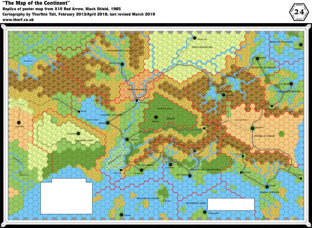
X10’s poster map served a dual purpose as both an overview map and a game board for the adventure. It was the first map to show the whole Atruaghin Plateau, confirming how the X1 and X4 maps join together. It also introduces Sayr Ulan, a new city in the Sind Desert that would later become the capital of the nation of Sind, as well as capitals for Alfheim, Atruaghin, Ethengar, the Five Shires, and Rockhome.
Additions
- Borders — The western borders of Atruaghin and Glantri appear here for the first time. The Black Eagle Barony border appears for the first time at this scale, but it doesn’t match very well with previous versions on 6 mile per hex maps — including the Karameikos map in X10. It’s not really big enough to show at this scale.
- Coastline — The southwestern corner of the map features a new piece of coastline, totalling about four hexes in length. This tiny section of coast of course appeared on regional maps, but this is the first time for it to appear on a hex map.
- Plateaus — The Atruaghin plateau appears as a cohesive whole for the first time. (Its eastern and western halves were previously featured on maps in X1 and X4 respectively.) The same is true of the as-yet-unnamed plateau to the north (later known as the Adri Varma).
- Settlements — The adventure requires capital cities for all nations, resulting in the creation of the following cities: Alfheim, Atruaghin, Dengar, Ethengar, and Shireton. Only Dengar and Shireton get their own names; the others are all named for their nation. Sayr Ulan also makes its first appearance here, marked as a city, but with no nation marked. The dwarven village of Stahl appeared on the 1983 Expert Set map without a name, but is named here for the first time. Kobos in Ierendi is in the same situation. (But strangely the other unnamed village introduced on that map, in eastern Glantri, is not on this map at all.) Athenos in Darokin appears here for the first time (see Borders in Revisions below).
- Trails & Roads — This map shows a far more extensive road network than previous maps. Many trails have become roads, and there are entirely new roads and trails. For example, the road west from Akesoli is entirely new. Strangely, the Corunglain-Darokin trail has vanished altogether, replaced by a new road to Akorros. (See also Revisions below.)
Revisions
- Borders — The Five Shires/Darokin border has been altered to give Darokin a sliver of coast east of the Malpheggi Swamp, which accommodates the port of Athenos. Three hexes of land and two of sea previously within Shire borders now belong to Darokin. A further five sea hexes to the immediate west of this have been reassigned from Atruaghin to Darokin; previously the border ran straight along the Malpheggi coast. Finally, a single hex northeast of Lake Amsorak has been ceded to Darokin from Glantri.
- Coastline — The southwestern island of Ostland appears here in its X1 (1981) form — merged with the smaller northwestern island.
- Rivers — All of the rivers have been normalised to the hex grid, so that they follow the edges of the hexes. This is likely due to the “game board” element of the map’s design. Additionally, only the Streel and the Asanda are named on this map.
- Settlements — Locations of many settlements are slightly different from previous maps. Most of these are minor, but a few are worth noting: Zeaburg has moved a full hex south; Soderfjord is almost a full hex northwest; Threshold is half a hex northeast; Rhoona is half a hex south; Akesoli is half a hex north; Kobos is half a hex south; and Corunglain is no longer west of the adjacent river fork, but instead has moved in between the two rivers. These changes are likely all due to conforming to the hex grid/”game board”.
- Spelling — Ylaruam is misspelled as “Emirate of Ylarum”. Tel Akbir is misspelled “Tel Akbar”. Kelvin is spelled with an “i”.
- Terrain — There are numerous small revisions scattered throughout the map. Most of the differences with previous maps are either hills to plains or plains to hills, although a few forest hexes (mostly Karameikos) and a couple of grasslands hexes (near Pramayama) are also revised. It’s all pretty minor stuff.
- Trails & Roads — A large number of trails have been changed to roads throughout the map.
Hex Art & Fonts
- Fonts — Libra BT throughout. This font does not have any upper case; capital letters on this map are simply enlarged lower case characters.
- New Symbols — The Atlas replica uses standardised hex art, but the original map had its own set of hand-painted hex symbols, unique to this map.
Map 39: “Grand Duchy of Karameikos” from X10 (November 1985)
From the Atlas of Mystara:
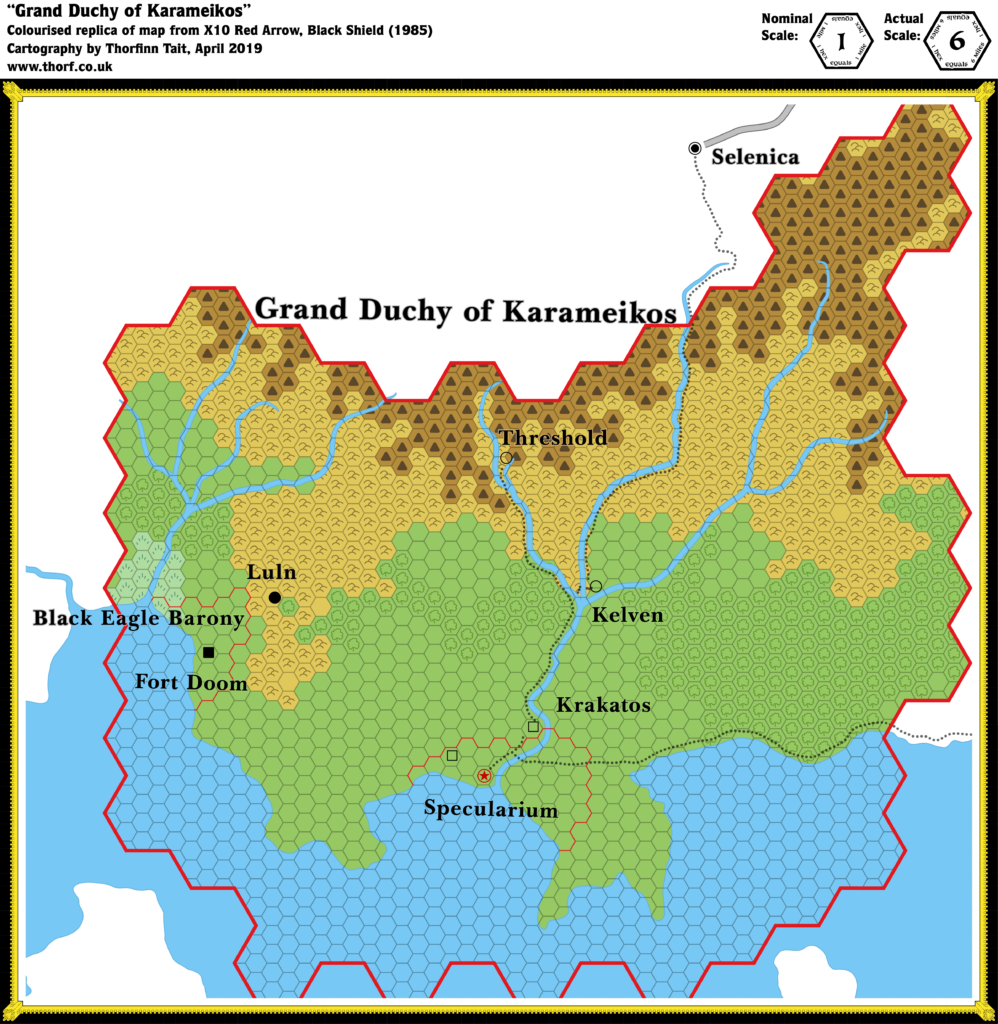
This map of Karameikos was featured in X10. It’s an adaptation of previous maps in the Expert Set (both 1981 and 1983), but with a couple of new errors and no new additions. This one is for completists only — even if you’re running X10, you’d be better off using one of the other versions.
Revisions
- Borders — The Karameikos border (shown at 24 miles per hex) has been shrunk by two hexes in the east and quite a few sea hexes in the south.
- Scale — The scale given on the map is “1 mile per hex”, though it’s clear from comparison with previous maps that this is just another 6 mile per hex map of Karameikos.
- Spelling — “Kelven” and “Specularium” both come from the 1983 Expert Set version of this map. Whether or not “Kelven” is an error is ambiguous, as both “Kelven” and “Kelvin” appeared in the text of the Expert Set (1983); the Atlas of Mystara goes with “Kelvin”. “Specularium” is a mistake only appearing on this map and its predecessor.
Hex Art & Fonts
- Fonts — Baskerville.
- New Symbols — None.
Textual Additions (X10 1985)
- Empires — Thyatis is said to control “several large islands off the southern coast of the continent” (p. 17).
- Fauna — Giant Roc in Roc’s Island, Ierendi (p. 16).
- Government — The governments and rulers of each Known World nation are detailed, adding to (and sometimes replacing) previous scattered details.
- Glantri is once again stated to be a magocracy governed by princes and princesses. The rulers are, however, “more concerned with magical research than with ruling”. X10 adds to this a High Council of State, composed of three princes. The implication is that this is just three of a larger number. (p. 11)
- Atruaghin is not so much a nation as a collection of clans, each ruled by a chief and a shaman. “If threatened by war, they unite temporarily under an elected leader.” (p. 12)
- The Five Shires share a “democratic tradition” with Darokin. The five sheriffs mentioned in X1 form the Council of Sheriffs. “Four times a year, the sheriffs meet at a great feast and decide shirewide policy by a vote.” (p. 12)
- Ierendi is nominally a monarchy, with the titles of king and queen given to “the greatest adventurers of the Kingdom”, but is actually an oligarchy, with true power held by “certain aristocratic families”. (p. 15) The Council of Lords is “the actual ruling body of the island kingdom”. (p. 16)
- The Minrothad government “is run by the heads of the various trading guilds”. Political arguments and dissension is said to be “often vicious”. The Guild’s Council “is made up of 40 of the most powerful guild leaders and barons. It is torn with angry arguments, exchanges of insults, and general unruliness.” (p. 17)
- The Empire of Thyatis is an autocracy, with the emperor holding “absolute power”, but “his decisions must allow for the desires of powerful nobles and for the threat of mob violence over unfavorable laws”. (p. 17)
- Vestland, Ostland, and Soderfjord are “composed of many petty ‘kingdoms’ that are loosely united under one ruler”. (p. 19)
- Islands — Roc’s Island is “a small crag jutting out of the sea”, one of the “outlying islands” of Ierendi. The island, a dormant volcano, is “rocky, small, and bare”. It takes 2 hours to climb to the top. (p. 16)
- Military — The module provides extensive details of wartime forces for all of the Known World nations.
- Races — Frost giants in Rockhome (p. 21). Their exact location is unclear, though there are enough to cause the dwarves significant problems. Large Red Dragon called Balefire in Alfheim (p. 23).
- Real-world analogies — The Atruaghin Clans description repeatedly uses “American Indian” customs as a reference (p. 12). Thyatis is once again compared to the Byzantine Empire (p. 17). Ylaruam’s culture “is similar to that of the Arabic desert states or the Central Asian city-states of Palmyra, Damascus, and Samarkand” (p. 18). Vestland, Ostland and Soderfjord culture resembles that of the Vikings (p. 19).
- Rulers — Most nations have their rulers named, with even more names appearing in the Army Unit Rosters.
- Glantri is ruled by princes and princesses. Three of these serve on a High Council of State: Prince Jherek (chairman), Prince Jaggar, and Prince Carlotina. (p. 11-12) The Army Unit Rosters list the names of more princes: Prince Morphail, Prince Brannart, Prince Volospin, Prince Vanserie, and Princess Carnelia. (p. 44) No details of races are given for any of the princes or princesses, so the assumption is that they are all human magic-users.
- The five sheriffs of the Five Shires are: Fosco, Saradas, Melilot, Holfast, and Madoc. (p. 12)
- Karameikos is ruled by Duke Stefan Karameikos the Third. Baron Ludwig “Black Eagle” von Hendriks is still in charge of the Black Eagle Barony. (p. 13)
- Ierendi’s figurehead monarchs are King Strongheart and Queen Mercion, while the true power, the Council of Lords, is comprised of Lords Meikros, Karibus, and Seilus. (p. 16)
- Thincol the Brave is once again said to be the Emperor of Thyatis. King Ericall of Norwold is also mentioned. (p. 17)
- The current Emir of Ylaruam is Emir Ali Ben Faisal. (p. 18)
- Four of Soderfjord’s jarls are given in the Army Unit Rosters: Olaf, Sven, Harald, Ragnar. (p. 48)
- King Gustav and King Olaf are referenced on p. 19 as kings (or jarls) of Ostland, Vestland, or Soderfjord; which nation they belong to is not fixed.
- Ethengar currently has no Khan, though Chanai is seeking to become “Khan of All Ethengar”. (p. 20)
- King Everest is “High King Under the Mountain”. (p. 20)
- King Doriath of Alfheim is the ruler of the elves. We also learn of a past king, the “legendary” King Alevar and his family: Queen Cerin and Prince Alecerin. (p. 22-23)
- Scale — p. 13 confirms the Karameikos map’s scale to in fact be 6 miles per hex.
- Settlements — Although X10 has an unprecedented amount of new setting information, it actually has surprisingly little on individual settlements.
- Akesoli is “a main trading port and commercial city on the shores of Lake Amsorak” and “the focus of all trade with the mysterious lands to the west, including Hule, the Savage Coast …, and other points west and south”. It’s also said to be “one of the most important cities of Darokin, thriving on all manner of business”. (All p. 3)
- Atruaghin is “not actually a city, but a meeting area where, once a year, the clans gather for a great festival.” (p. 12) The “grassy plateau, forest, and hilly regions are inhabited by herders, hunters, and fishermen who live in small villages”. (p. 12) Though these villages are not marked on the map, the Army Unit Rosters provide the names of eight clans: Bear, Horse, Tiger, Wolf, Boar, Sea Turtle, Elk (p. 44-45)
- Shireton is mentioned in the text, but not by name — only as “the halfling capital” (p. 13). There is a ruined temple “approximately 10 miles” from Shireton. It is “a modified Grecian-style building”. (p. 13)
- Ylaruam (spelled “Ylarum” throughout the text) “is located at the largest oasis in the Alasiyan desert” (p. 18).
- Ethengar‘s capital city is “actually a collection of grubby tents”. (p. 20)
- There are dwarven towns “in the Cruth Mountains that form the northern border of Karameikos”. (p. 20) Previous Karameikos 6 mile per hex maps included a single label for dwarves in the Cruth Mountains, though it was in the mountains north of the Five Shires.
- Dengar, the dwarven capital, is described in the text, although like Shireton it is not referred to by name: “a huge dwarven city wending its way through the caverns beneath the mountain range. The capital is at least 50 miles long. There are endless corridors, city blocks filled with bustling dwarves, strange mechanical devices like nothing else in the world, and forges where hun- dreds of dwarven engineers create truly amazing weapons and armor.” (p. 20)
- Alfheim‘s capital is unnamed in the text, referred to as “the tree-city in the heart of the forest” and described as follows: “The city of the elven king is incredibly strange and beautiful. Much of it is concealed—the city appears to be open forest. Tall, stately trees have spidery pathways hung between them. The elven construction seems never to use straight lines; the houses are formed from natural wood, with the innate shape of the wood reflected in the design of the house. When you enter, you find a spacious, light-filled chamber, with only natural things around you.” (p. 22)
- Sayr Ulan is “an immense tent city with several hundred thousand inhabitants, both Desert Nomads and citizens of the land of Hule”. “The city sprang up virtually overnight, with people pitching tents and building crude, makeshift homes wherever they could find an unoccupied piece of land. There are no streets as such, just narrow lanes between houses. The unplanned nature of the city is its most distinguishing characteristic. Reeking animal pens are next to tents inhabited by people; there are no stores, only merchants hawking their wares from carts. Water is the most common commodity being sold. Huge campfires burn day and night, providing fires for cooking in the day and illumination at night. The city is incredibly filthy; there is no sanitation system. Offal and waste litter the streets; the smell of camels, a particularly pungent odor, is everywhere. Sayr Ulan is built in three rings: the Outer City, inhabited exclusively by peasants and soldiers, the Inner City, inhabited by mer- chants, higher-ranking soldiers, and the less- destitute peasantry, and in the center of the city, the Camp of The Master.” (p. 28)
- Shipping Lanes — “Ships leave Specularum daily for Ierendi and the Minrothad Guilds; ships also travel daily between Ierendi City and Minrothad City.” (p. 13) This confirms the shipping lanes drawn in previous maps.
- Spelling — The text references the “Gulf of Hulag” (p. 13). This was likely a simple misspelling of the previous “Halag”. Karameikos’s duke is here listed as “Stefan”; previous sources used both “Stefan” and “Stephan”. (p. 13) The “Emirate of Ylarum” spelling from the map is repeated numerous times in the text; in fact the spelling “Ylaruam” does not appear in the text at all, even for the city. (p. 17-19)
- Terrain — X10 continues X1’s idea that the island south of Thyatis city is “the southern peninsula”, separated from the mainland by “a large canal”. (p. 17)
- Trails & Roads — Ylaruam sits at “the center of caravan routes crossing from north to south and from east to west”. (p. 18) While three of these have been previously established, the route leading east has not appeared on any map. As of 1985, there is nothing for it to lead to. In Rockhome, the dwarves’ toll road (previously mentioned in X1) is mentioned again. The extent of the roads on the map now stretch throughout Rockhome, whereas previously there was just a single road from the Ylaruam border to the middle of Rockhome. (p. 20)
The Maps So Far: 1985
Head on over to the Atlas of Mystara web site, where the 1985 maps have a permanent home. Or continue reading here for a short summary.
Five years into its publication, here’s how the world shapes up:
- The world has its first explicit name: The Known World.
- The whole world is split up into major regions, with labels for each area — but most of the labels exist without any further explanation. The continents themselves are still nameless.
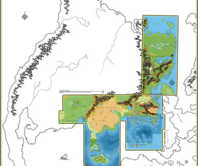
- Reference to the original inspirational Jurassic Earth map has allowed us to establish the map’s underlying projection, the Mollweide Projection.
- The continental maps and hex maps can all be placed on the world map, although in some cases rescaling is necessary to make them fit. The vast majority of maps have a different rotation from the world map.
- Hex map coverage at 24 miles per hex now stretches from the Orcs Head Peninsula in the far west all along the coast to Thyatis, then north to Norwold. Neither of the other major continents yet appears on any hex maps, although the southern one should peek into the corner of the Serpent Peninsula map.
- Coverage at larger scales is still very scant, with only Karameikos and the Isle of Dread getting treatment at 6 miles per hex or larger.
- The world’s major detailed regions are: the Savage Coast, Hule, the Great Waste, the Serpent Peninsula, the area of the X1 map (still unnamed), and Norwold.
- There is a major conflict in the depiction of Alphatia, with the world map clashing with the 138 (nominally 150) mile per hex map. Since the latter doesn’t show all of Alphatia, this is unresolvable at this time.
We can now deduce the dimensions of the world based on the assembled maps, their scale, and the Mollweide projection.
- Circumference: 33,032 miles
- Radius: 5,257 miles
- Land Area: 95,874,509 sq. miles (28%)
- Sea Area: 251,480,548 sq. miles (72%)
By the same token, the land areas of the nations marked with borders on the hex maps are as follows:
- Alfheim: 23,945 sq. miles
- Atruaghin: 61,798 sq. miles
- The Broken Lands: 15,465 sq. miles
- Darokin: 111,658 sq. miles
- Ethengar: 77,822 sq. miles
- The Five Shires: 12,885 sq. miles
- Hule: 195,881 sq. miles
- Ierendi: 17,487 sq. miles
- Karameikos: 40,935 sq. miles
- Minrothad: 7,815 sq. miles
- Norwold: 1,111,040 sq. miles
- Oceansend: 7,862 sq. miles
- Ostland: 9,464 sq. miles
- Rockhome: 54,875 sq. miles
- Soderfjord: 32,212 sq. miles
- Thyatis: 61,915 sq. miles
- Vestland: 21,336 sq. miles
- Ylaruam: 55,034 sq. miles
These figures are for the land within the hex borders and the coasts. Darokin does not include Alfheim, and Norwold does not include Oceansend. The Five Shire/Darokin border is based on X10.
And that’s it for 1985. Apologies for the extended period of waiting — it took more than a year between 1984 and 1985’s posts. Don’t forget to check out the 1985 maps, and see you next time for 1986!
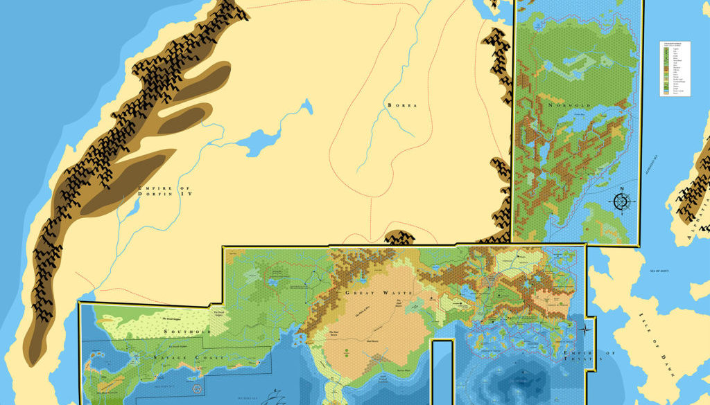
3 May 2019 @ 1:08 am
Hurray for 1985! This is an absolutely fascinating journey across the maps of Mystara.
Thanks Thorf!
27 May 2019 @ 10:27 pm
Excellent work – many thanks for posting this. The ‘Let’s Map Mystara’ series is turning into an invaluable resource for Mystaran cartographers!
27 May 2019 @ 11:11 pm
Thank you very much! That’s exactly what I was hoping. 🙂
I wasn’t sure at first, but it seems increasingly likely that this project is gradually going to subsume and eventually supersede my series of updated maps. The end product of the last year of publication, 1996, should be a complete set of all existing official maps, adjusted for internal consistency but otherwise completely faithful to the published maps. I haven’t decided where to go from there, but it would certainly be fun to continue through the body of fan-made maps, investigating the continuing development of the world. To make that practical would require a slightly different approach post-1996, and there are all sorts of problems with dating fan-made maps, and there’s just so many of them.
But that’s very long-term. I hope to release the new set of updated maps after dealing with 1996, and from there it’s on to new projects, such as topographical maps and creating DEMs.
27 August 2020 @ 11:52 pm
Hello.
I love your maps and especially the “Lets Map Mystara” project. I noticed that its been more than a year since there was an update on this project. I’m hoping that it hasn’t been canceled. I’ve been very excited about it and seeing how Mystara evolved over the years. Mystara was my first experience in D&D and I own a physical copy of nearly every product that was made for it all (including several Dungeon magazine issues and AD&D products that I’m curious if they really fit or not). Of course, knowing how it all goes together and can be reconciled (especially how the smaller, more detailed maps fit with the larger ones).
Anyway, you do amazing work!
I hope this finds you & your family safe, healthy, and happy.
28 August 2020 @ 12:16 am
Hello Chris!
Don’t worry, I’m in this for the long haul. The whole Atlas of Mystara project began in January 2005, so I’ve been at this for more than 15 years at this point. I have no intention of stopping; on the contrary, I have great plans for the future, and I’m determined to get there.
It’s just that it all takes time. And I’ve been especially busy this year with other work.
That said, I’ve actually made great progress on Let’s Map Mystara 1986, and recently I have finally managed to move past the sticky knot that was holding me back — B10’s version of Karameikos. Most of the maps for 1986 are either done or nearly done, and things are moving forward once again. I’ve even begun preparation of 1987’s maps. (I couldn’t resist, because 1987 is the year when the Gazetteers debut, and things really start to snowball.)
When I’m stuck on something or busy with other projects I don’t tend to post much, but don’t worry, I always come back before too long. Comments such as yours are always a bit motivator for me to get back to Mystara! For which you have my thanks. 🙂
Master Set Outer World | Atlas of Mystara
29 May 2021 @ 8:39 pm
[…] This is Map 32. It was published in 1985. The updated version of this map has not yet been released. See also Appendix C for annual chronological snapshots of the area. For the full context of this map in Mystara’s publication history, see Let’s Map Mystara 1985. […]
Outer World (1985) | Atlas of Mystara
23 January 2022 @ 12:39 am
[…] Let’s Map Mystara 1985 — the original project thread for this map […]
Brun (1985) | Atlas of Mystara
23 January 2022 @ 9:08 pm
[…] Let’s Map Mystara 1985 — the original project thread for this map […]
Norwold & Alphatia, 138 mph (1985) | Atlas of Mystara
26 January 2022 @ 8:34 pm
[…] Let’s Map Mystara 1985 — the original project thread for this map […]
Vyolstagrad, 2 miles per hex (1985) | Atlas of Mystara
29 January 2022 @ 5:50 pm
[…] Let’s Map Mystara 1985 — the original project thread for this map […]
Brun, 24 miles per hex (1985) | Atlas of Mystara
1 February 2022 @ 9:01 pm
[…] Let’s Map Mystara 1985 — the original project thread for this map […]
The Multiverse (1985) | Atlas of Mystara
6 February 2022 @ 12:03 am
[…] Let’s Map Mystara 1985 — the original project thread for this map […]
Karameikos, 6 miles per hex (1985) | Atlas of Mystara
6 February 2022 @ 12:13 am
[…] Let’s Map Mystara 1985 — the original project thread for this map […]
Savage Coast, 22.9 miles per hex (1985) | Atlas of Mystara
6 February 2022 @ 12:15 am
[…] Let’s Map Mystara 1985 — the original project thread for this map […]
Emerlas, 3 miles per hex (1985) | Atlas of Mystara
6 February 2022 @ 12:18 am
[…] Let’s Map Mystara 1985 — the original project thread for this map […]
Isle of Dread, 4 miles per hex (1985) | Atlas of Mystara
7 February 2022 @ 9:00 pm
[…] Let’s Map Mystara 1985 — the original project thread for this map […]
Serpent Peninsula, 24 miles/hex (1985) | Atlas of Mystara
24 February 2022 @ 10:46 am
[…] Let’s Map Mystara 1985 — the original project thread for this map […]
Proto Mystara | Atlas of Mystara
7 March 2022 @ 8:52 pm
[…] This was the inspiration for Mystara’s world map in the Master Set (Map 32). It was published in 1983, in the Time Life Planet Earth series book, Continents in Collision. For the full context of this map in Mystara’s publication history, see the article Jurassic Earth as Mystara and Let’s Map Mystara 1985. […]
Savage Coast, 24 miles per hex (1985) | Atlas of Mystara
9 April 2023 @ 9:29 pm
[…] Let’s Map Mystara 1985 — the original project thread for this map […]
Known World, 24 miles per hex (1985) | Atlas of Mystara
24 September 2023 @ 11:15 am
[…] Let’s Map Mystara 1985 — the original project thread for this map […]
Legend (1985) | Atlas of Mystara
24 September 2023 @ 12:08 pm
[…] Let’s Map Mystara 1985 — the original project thread for this map […]
Great Waste, 24 miles per hex (1985) | Atlas of Mystara
24 September 2023 @ 2:19 pm
[…] Let’s Map Mystara 1985 — the original project thread for this map […]
Hule, 24 miles per hex (1985) | Atlas of Mystara
24 September 2023 @ 4:34 pm
[…] Let’s Map Mystara 1985 — the original project thread for this map […]
Norwold, 24 miles per hex (1985) | Atlas of Mystara
24 September 2023 @ 5:24 pm
[…] Let’s Map Mystara 1985 — the original project thread for this map […]